Evening Update: Winter Storm Warning issued for all of SE WI Thursday morning through Saturday morning


Updated: Wednesday, December 21st 3pm:
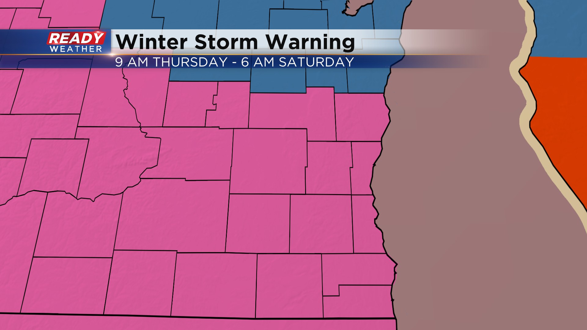
A Winter Storm Warning is now in effect for all of southeast Wisconsin beginning 9am Thursday through 6am Saturday.
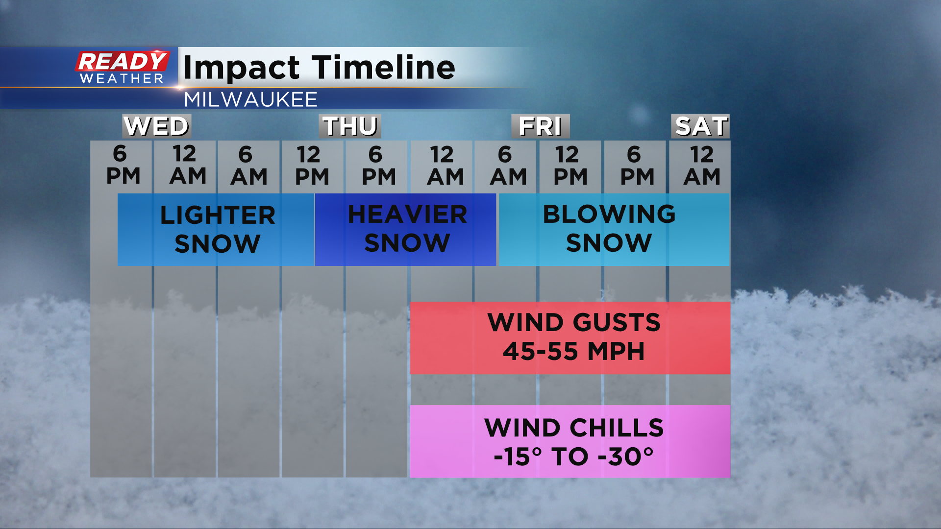
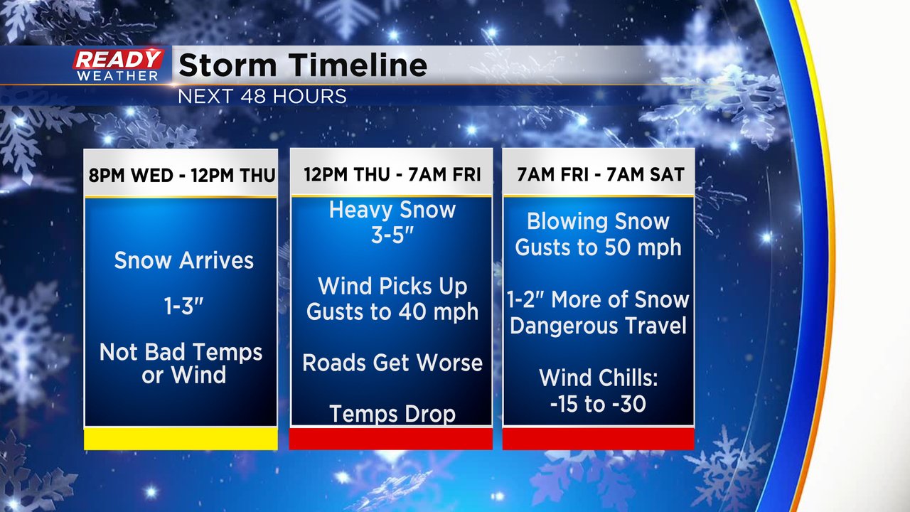
A majority of the snow will fall tonight through Thursday night. The strong winds of 45-55 mph will move in Thursday night as the snow is wrapping up and continue all day Friday. This will cause wind chills to drop between -20 and -30 all day Friday into Saturday morning and cause blowing, drifting, and low visibility. Wind gusts will still be around 40 mph all day Saturday so plan on -15 to -30 wind chills to continue. Expected snow totals from this event remain unchanged from the previous update.
-----------------------------------------------------------
Updated: Wednesday, December 21st 1pm:
Not too much in the way of changes with the latest round of model data. Our impact timeline remains virtually unchanged with light snow beginning tonight and continuing through Thursday morning. More moderate to heavy snow arrives later Thursday into Thursday night with most of the accumulating snow wrapping up early on Friday. Wind will start to become very strong Thursday night through Friday with sustained winds of 25-35 mph, gusting 45-55. Although the snow will basically be done on Friday, but those strong winds will create blizzard-like conditions all day, making for difficult travel.
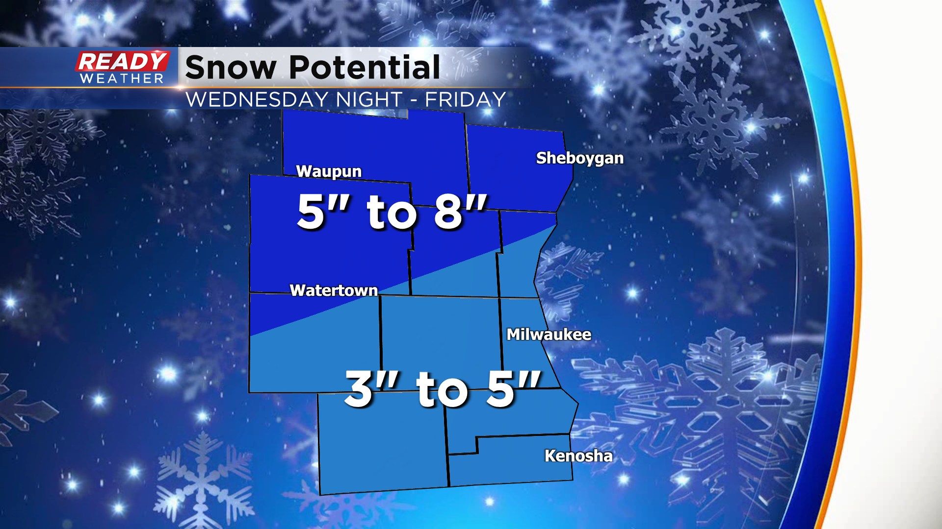
Overall snow totals haven't changed much. A solid 2-5" for a good chunk of SE WI with totals ranging from 5-8" far north and west. Again, most of the snow will fall on Thursday and then blow around on Friday and create low visibility on Friday.
Another updated will be posted by late afternoon.
-----------------------------------------------------------
Wednesday morning is the calm before the storm. We are waking up to a little bit of sunshine with clouds returning by Wednesday afternoon then snow arrives Wednesday evening after 8 PM. Scattered snow showers are likely Wednesday night through early Thursday morning. Some communities could have 1-3" of snow on the ground by the Thursday morning commute. The snow becomes steadier and heavier Thursday afternoon and evening through early Friday morning. One of the questions in the forecast is when the snow ends. Some weather models have it mostly wrapped up by Friday morning while others keep in a few snow showers that add additional snow.
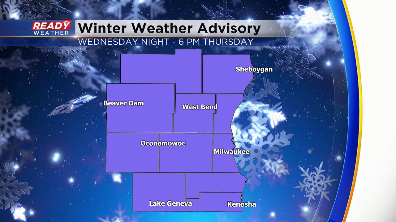
A winter weather advisory has been issued for all of southeast Wisconsin that starts tonight through 6 PM Thursday. This is for the first half of the storm where the wind won't be as bad. About 3-6" of snow will be possible during this advisory.
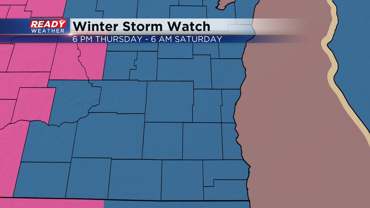
A winter storm watch is still in place for all of southeast Wisconsin for the second half of the storm from 6 PM Thursday to 6 AM Saturday. This watch could be upgraded to another advisory or winter storm warning or blizzard warning are still a possibility with blowing snow the big issue.
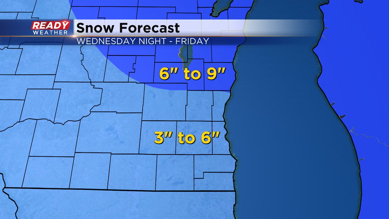
Weather models are starting to show more consistency. 3-6" of snow looks likely for most of southeast Wisconsin including the Waukesha/Milwaukee metro areas. 6-9" may be possible in our northern counties. Expect some adjustments to this map as we snow starts falling.
The strong wind will continue to be a huge part of this storm. Wind gusts will ramp up Thursday evening to 25 mph. Strong wind is likely on Friday with gusts to 50 mph causing near blizzard conditions. Saturday's wind also stays strong with gusts to 40 mph leading to blowing snow even if we don't have any more snow falling from the sky.

The strong wind combined with falling temperatures will really drop wind chills going into the holiday weekend. Wind chills Friday morning could be as cold as -30 and don't get warmer than -15. Wind chills will stay in the range for Saturday with some minor improvement on Christmas Day with wind chills in the morning as cold as -20.
A wind chill advisory is likely. A wind chill warning is possible.

Download the CBS 58 Ready Weather app to track the snow, wind gusts and dangerous wind chills.