4:00 PM Update: Tornado Watch has been issued until 10 pm.
Update as of 4:00 pm Tuesday, April 14th

A tornado watch has been issued for the entire area until 10 pm.

The cap has eroded across Wisconsin with storms popping west of Madison. Over the next few hours, the storm coverage will increase to our west. Storms move into our area between 5pm and 10 pm.
All kinds of severe weather hazards are possible. We still have an Enhance risk of severe storms across the region. If it's upgraded to a Moderate risk, we'll let you know. This would be a level 4 of 5. Honestly, I really don't see an end in sight to this pattern. It won't be until later Saturday morning, behind a cold front, we can change the forecast for the cooler and drier.


Look at these rainfall amounts into the end of the week...

__________________________________________________________________________________________________________
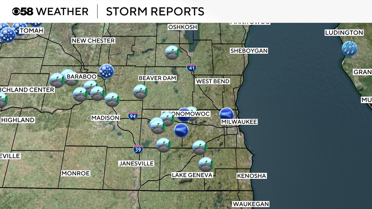
Severe Weather Awareness Week in Wisconsin is off to a bang, literally. A round of strong and severe storms rolled through southeast Wisconsin just after midnight Monday night into Tuesday morning. Some tornado warnings were issued along a line of storms that was moving through southeast Wisconsin. There were numerous reports of trees down and even some roof damage in some areas. A home in Jefferson lost its roof and there's a report of a barn collapse in Fond du Lac County with cows inside. We also saw a few severe thunderstorm wind gust reports around 60 mph in Milwaukee and Jefferson County.
As of 6 AM Tuesday all of the overnight rain and storms have wrapped up and we will stay dry through most of the morning and early afternoon hours. It will still be a warm and slightly muggy day so that's your best chance to enjoy some of the warmer temps. After 4 PM the chance for severe storms will increase. Initially some of the storms look like single cells. These individual cells typically have a better damaging hail and tornado threat. Eventually the storms likely form into more of a line or a mass which will increase the strong wind threat.

Strong and severe storms will continue, in at least some fashion, through late Tuesday evening into early Wednesday morning. Damaging wind and hail will be the main threats with any severe storms. But the tornado threat is high, even the possibility for strong tornadoes. Flooding is also possible, especially after how waterlogged the ground is after heavy rain the last few days.

Rain totals for Tuesday evening through Wednesday morning could reach up to an inch. Even higher totals are possible in any strong or severe storms we get which could lead to some wet basements or some minor street flooding. We are also watching river levels closely with a flood watch likely issued later Tuesday.

A Level 3 Enhanced Risk for severe weather remains in place for all of southern Wisconsin for Tuesday. We only average a few Enhanced risks during the year in southern Wisconsin and we have already seen a couple to start 2026 with an active start to our severe weather season.

The chance for strong to severe storms doesn't end on Tuesday, Wednesday also has the possibility for scattered showers and storms throughout the day. Some of the storms on Wednesday could still be strong or borderline severe. A Level 2 Slight Risk is still in place for most of southeast Wisconsin. There is still a chance for storms on Thursday but our severe risk mostly goes away. Friday night into Saturday could see another round of strong or severe storms.

Download the CBS 58 Weather app to use the interactive radar to track the storms and get alerts in case tornado watches or warnings are issued.

Stay ahead of the forecast with CBS 58 Weather for live radar, hourly and 7-day forecasts, current temperatures, wind speeds, weather watches and warnings, driving conditions and live camera views from across southeast Wisconsin.


The CBS 58 News and CBS 58 Weather Apps are here and totally free! Stay up to date with the most important News & Ready for whatever mother nature has in store for us with CBS 58 Weather. No matter where you are, or what time it is, the CBS 58 Apps are here for you.
Check out everything these Apps have to offer from News, Traffic, Sports, Weather, Interactive Radar, Daily/Hourly Forecasts, and more! All with the speed and ease of use you would expect from the CBS 58 News Team.
