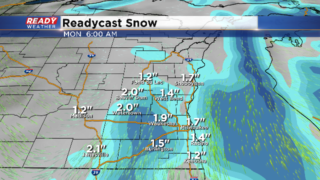
Snow for Sunday into Monday
The arctic blast for the weekend will get another shot in the arm as a fast moving clipper drops in from Canada. This clipper will not only drag in cold air for Monday into Tuesday, but it will provide the lift for moderate snow to fall.
As with all of our clippers this winter, there's not a lot of moisture to work with. These events feature a dry powder like snow; however, with the cold air in place, that type of snow quickly accumulates and causes slick areas on roads.
The snow is forecast to start after dark Sunday night. Initially it will probably have to overcome some dry air, but then it will gain steam late Sunday night into Monday morning. This will likely cause issues for the Monday morning commute.
These types of systems will produce a quick 1" to 3" of snow areawide. The models linger the light snow through Monday afternoon, so roads could be slick most of the day. Temperatures will drop back into the teens for Tuesday, but warmer changes are in the cards toward the end of the week. We could see a string of 40+ degree temperatures.
