Saturday Afternoon Update: Accumulating snow ending as wind picks up
A few areas of snow flurries are still flying across southeast Wisconsin but little to no additional accumulation is expected. Snow totals are continuing to come in and most spots are between 3-7". A few reports are just over 7" including areas in and around Waukesha County. Now that the snow has mostly wrapped up, the wind is starting to pick up. Wind gusts are starting to push over 20 mph. Blowing and drifting snow will likely become an issue the rest of Saturday.

A cold front is also expected to roll through this afternoon dropping temperatures quickly. Wind chills by Sunday morning will be in the teens and 20s below-zero. A wind chill advisory has not been issued yet but is possible for at least part of southeast Wisconsin.

A flash freeze is also possible as the arctic air moves in between 4 pm and 6 pm. A very quick drop in temperature could create more ice on roads.
------
Updated: 9:26 a.m. January 18, 2020
Light snow and wintry mix are continuing to move through southeast Wisconsin. Expect pockets of precipitation to last until around lunchtime Saturday before coming to an end. The wind will likely pick back up later Saturday bringing in much colder air. Watch for icy spots Saturday afternoon/evening as temperatures fall into the teens.

Here are some of the latest reports as of 9:30 a.m. Most areas are coming in between 4-7".
Waukesha 5.8"
Rochester 5.3"
New Berlin 5.0"
Fort Atkinson 5.0"
Fond du Lac 5.0"
Beaver Dam 5.7"
Pell Lake 3.0"
Mukwonago 6.8"
Caledonia 5.0"
Plymouth 5.2"
Jackson 3.0"
Germantown 5.5"
Howards Grove 6.5"
Pleasant Prairie 5.0"
Grafton 7.5"
A winter weather advisory remains in effect until 6 p.m. Saturday for all of southeast Wisconsin. The advisory is for any additional snow and wintry mix as well as the chance for blowing and drifting snow this afternoon and evening that will lead to low visibility and slow driving conditions.
------
Updated: 7:32 a.m. January 18, 2020
The bulk of the accumulating snow fell overnight. Most spots are waking up to 4-7" of snow. Some snow reports coming in include 6.4" in Waukesha, 3.9" in Sullivan, 5.2" in Madison, 5.2" in Milwaukee. and 4" in Cedar Grove.
A mixture of light snow and some wintry mix including freezing rain is currently falling. Here's the latest radar:

Expect the light mix to continue through the rest of the morning with rapidly falling temperatures this afternoon. If you want to play in the snow make sure you do it early in the afternoon because by evening it will be cold. Wind chills Sunday morning are n the teens and 20s below-zero.
-------
Updated: 11:00 p.m. January 17, 2020
Roads are snow covered across the entire area. Heavy snow and wind along with temperatures in the 20s have contributed to the mess on the roads. Travel is not advised.


Some areas have already picked up 2" to 4" of snow. Several more inches are possible overnight. By morning most areas will wake up to 4" to 7" of snow. A warm layer will likely cause a mix to develop overnight as temperatures rise into the lower 30s. That mix could cause a light glaze for more slick travel.

By tomorrow afternoon we will expect another round of light snow before a flash freeze develops by the early evening. It would be a good idea to get the shoveling done in the morning.
_____________________________________________________________________________________________________________
Update: 6 PM
Snow has now covered the viewing area and it's coming down at a fast clip. Locations have been reporting snowfall rates at about an inch per hour. As we factor in the southeast wind, visibility will continue to be an issue for the remainder of the night as steady snow continues into tomorrow morning. Here's the latest look at Ready Doppler:

Update: 4 PM
Snow is entering the viewing area at this time. In just one hour of flakes flying, the city of Madison already picked up an inch of snow. Additionally, winds from the southeast gusting over 20mph is leading to very poor visilibity.

The storm is still on track to provide 3-6" of snowfall with isolated higher amounts and also that chance for some mix for southern spots Saturday morning. The other important thing to note is that temps will drop quickly as this storm departs. A flash freeze of any liquid on surfaces is possible. By late Saturday night wind chills will drop to 20 below zero and that will lead to frostbite development in just 30 minutes.

Please limit time outdoors by late Saturday through much of Sunday with the bitterly cold air set to follow this storm.
Update: 2 PM
No real changes to the going forecast. After the atmosphere saturates this evening, we expect moderate snow to fall across southeastern Wisconsin. With temperatures in the 20s this will stick on roads and create slick travel.

Snow will continue overnight into Saturday morning. Most areas will pick up between 4" to 6" of snow. Models have been fairly consistent with totals. Some mixing will occur int he morning before turning back over to light snow in the afternoon.

The other big story is the flash freeze by Saturday afternoon. The snow looks to move out with a blast of arctic air to follow. Very slick roads are expected Saturday night.
______________________________________________________________________________________________________________
Update: Noon, January 17, 2019
Our line of thinking with this latest storm remains the same. Look for snow to overspread the area by the evening. It'll last through the morning hours of Saturday and into the afternoon. A Winter Advisory will be in effect from this evening into Saturday evening. At least 3 to 5 inches of snow can be expected with higher amounts, especially north of I-94. An icy mix and mess could be problematic, especially throughout Saturday. Rain is possible too, mainly around the metro and points south. Of course any ice or snow will possibly keep the snow amounts on the lower side.


Behind this system starting as early as Saturday afternoon, temperatures will really start to fall off. In fact, wind chill numbers will be between -10 and -20 as you wake up Sunday. Make sure to bundle up when heading out Sunday (and clear off the snow as soon as you can on Saturday before it freezes later in the day Saturday.)
----------------------------------------------------------------------------------------------------------------------------------------------------------------------------------
Updated: 9:50 a.m. January 17, 2019
Snow is still on track to arrive by late afternoon or early evening, mostly missing the bulk of the evening commute.

Most of the steady and heavy snow falls Friday night so driving will be difficult with 2-6" falling by Saturday morning. The morning hours of Saturday could see a wintry mix of rain, snow, sleet and freezing rain to the south and light snow to the north. A glaze of ice and up to 1" of snow are possible. Little to no additional snowfall is expected Saturday afternoon but temperatures will fall quickly.

------
Posted: 5:03 a.m. January 17, 2019
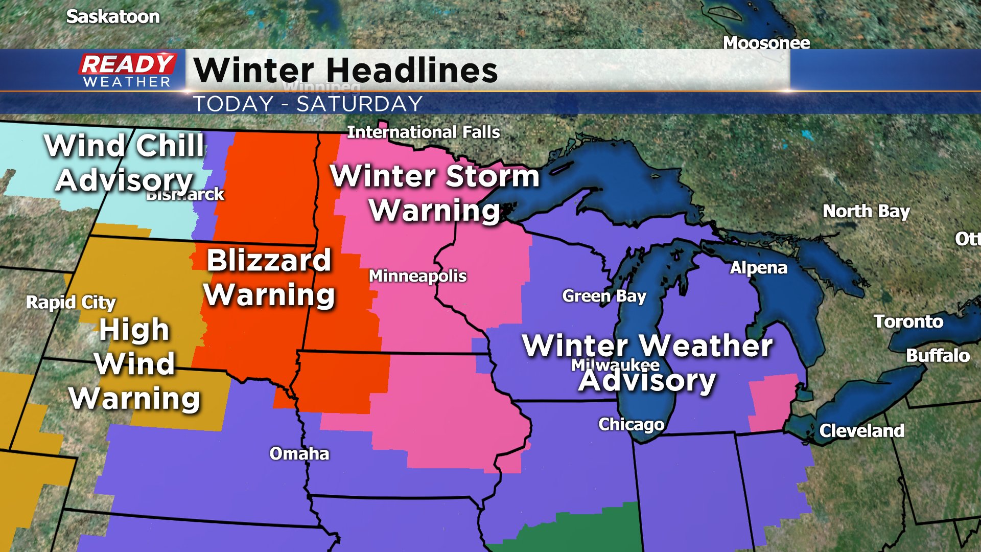
The day the snow will arrive is finally here. Thankfully, the snow misses the heart of the day with both the morning commute and most of the evening commute remaining dry. If you don't leave work until after 6 p.m. or 7 p.m. expect snow to be falling. A winter weather advisory starts at 5 p.m. Friday evening and lasts just over 24 hours until 6 p.m. Saturday.

The storm is expected to be worse to our west where winter storm warnings have been issued for northwest Wisconsin and blizzard warnings for western Minnesota and the eastern Dakotas where the wind will gust to 50 mph at times.
Once the snow starts Friday evening it quickly becomes steady with the heaviest of the snow falling overnight into early Saturday morning.
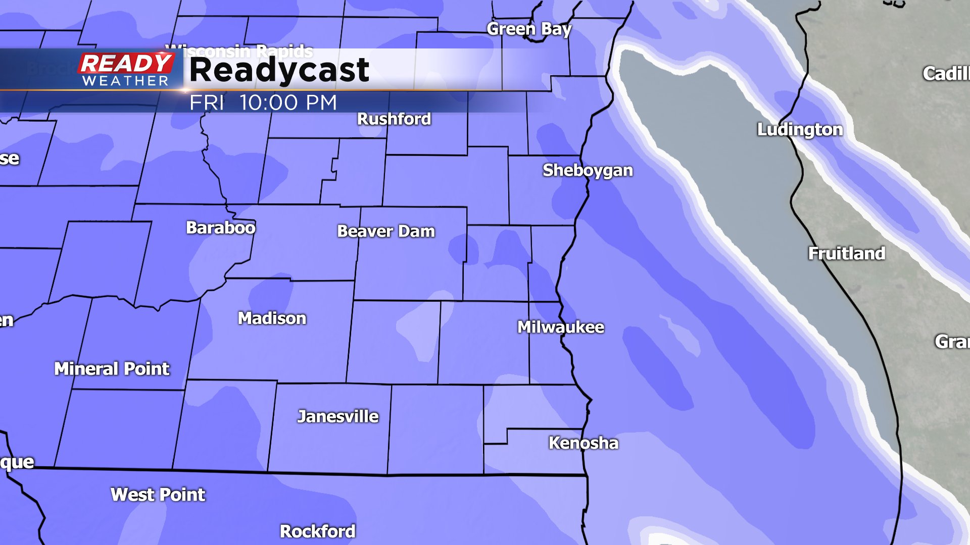
By the time many of us wake up Saturday morning there will be about 3-6" of snow on the ground. Areas along and south of I-94 may get a period of wintry mix including sleet, freezing, rain, snow or mix of any of them. The best timing for this wintry mix will be from 6 a.m. to noon on Saturday. A touch of light snow will wrap in late Saturday morning and early afternoon with little to no accumulation before the storm comes to an end.

The wind will pick up Friday so breezy conditions are possible Friday evening with blowing snow. Visibility will be pretty low Friday night and Saturday with the falling snow. The snow and wind will be the biggest threats with the storm. Wintry mix is a secondary threat Saturday morning and cold won't be a huge issue until after the snow ends as temperatures drop quickly.
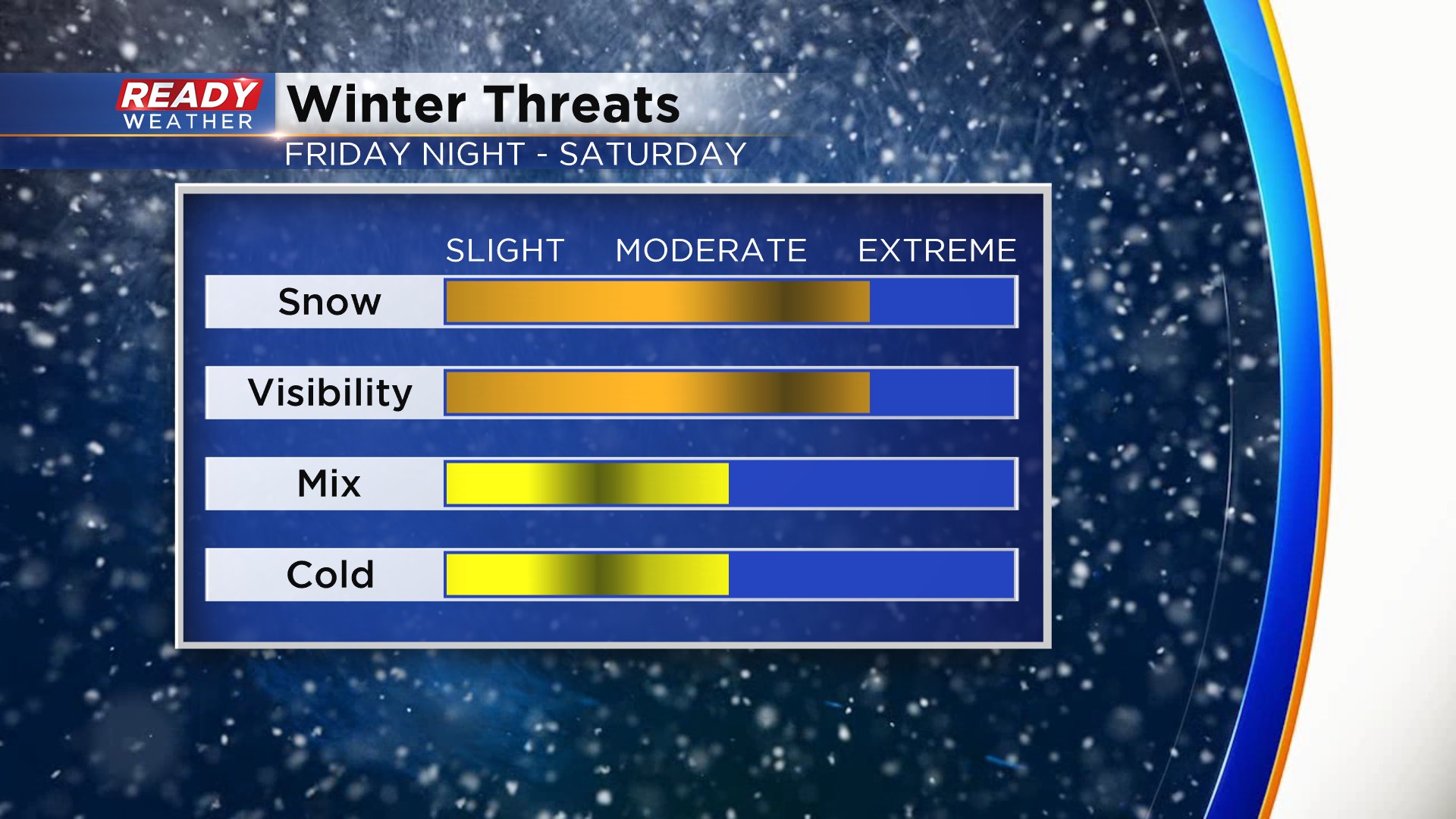
Sunday is on track to be the coldest day of the season with lows in the single digits and highs barely above 10°. The wind will still be strong so wind chills Sunday morning will be near wind chill advisory criteria in the -15° to -25° range.

Download the CBS 58 Ready Weather app to track the snow Friday night and the cold for Sunday.
