Monday Mid-Morning Update: Multiple rounds of strong storms possible today


Updated: 9:32 a.m. Sep. 13, 2021
That second of thunderstorms is over and has moved over Lake Michigan. Nothing severe with those cells but there were a couple reports of wind gusts in the 30-40 mph range and a few reports of hail the size of pennies and nickels. A few showers could linger through the rest of the morning and we're already watching an area of storms in Southwest Wisconsin that will move our way throughout the morning. Once again, some strong to severe thunderstorms will be possible.
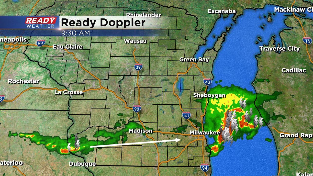
These storms are forming along a stationary front that's sitting over southeast Wisconsin almost right over I-94 which is causing those areas to get the heaviest rain. During the day that front should lifted slowly north giving our northern counties the better chance to see some storms Monday afternoon and evening. Eventually a cold front will push through on Tuesday bringing in another chance for showers and storms for everyone. Any of the storms we see Monday and Tuesday could be strong to severe.
------
Updated: 8:10 a.m. Sep. 13, 2021
A second round of storms is rolling in. As of 8:10 a.m. none of the storms are warned but they are strong with penny sized hail and wind gusts to around 40 mph. There's also a lot of lightning and some very heavy downpours with the storms. The strongest part of the storm is the same area that got dumped on with rain before 4 AM so ponding of water on the road is likely.
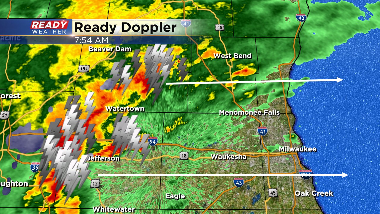
After these storms roll through we will likely see just a few isolated showers and storms through the rest of the morning into the afternoon and evening. There is a risk for severe weather with any storms that develop.
------
Posted: 6:41 a.m. Sep. 13, 2021
A lot of you woke up to strong and severe storms as they rolled across southeast Wisconsin Monday morning from 2 to 4 AM right along I-94 through Jefferson, Waukesha and Milwaukee Counties. A few reports of hail came in around penny to nickel size. Check out the lightning in downtown Milwaukee as the storms rolled through. At one point we were averaging over 200 lightning strikes every 15 minutes.
Check out the lightning early this morning just before 4 AM! We were averaging about 200 lightning strikes every 15 minutes as the severe storms rolled through. @MikeCurkovpic.twitter.com/02JICHwhJO
— Justin Thompson-Gee (@JustinTGee) September 13, 2021
The severe storms early Monday combined with some downpours are severe storms Sunday afternoon meant some of us got a really good soaking rain the last 24 hours. A few locations saw close to or just over an inch of rain. Most that saw the storms saw at least a half inch. Our northern and southern cities like Fond du Lac, Sheboygan, Lake Geneva, Racine and Kenosha didn't get much at all.

Another round of storms is currently rolling through southeast Wisconsin. As of 7 AM storms are rolling through the Madison area and moving east. A few stronger or even severe storms can't be ruled out Monday morning. Hail is the primary risk. A marginal risk (level 1 of 5) for severe weather is in place for all of southeast Wisconsin with a slight risk (level 2 of 5) just to our northwest. The marginal risk is both for storms Monday morning as well as a few isolated storms in the afternoon and evening.
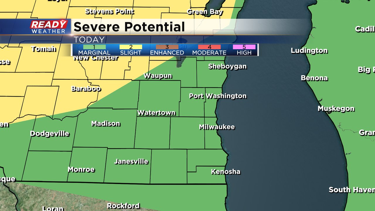
We also have a marginal risk for areas east of a line from Milwaukee to Lake Geneva for Tuesday with another chance for strong to severe storms. Rain totals for both Monday and Tuesday will be heavily dependent on storms which means while some could get another full inch of rain others only see a tenth.

Download the CBS 58 Ready Weather app to track the rain and get any alerts if warnings are issued.