
-
1:15

Engel Conservation Area offers peaceful escape in Muskego
-
4:56

Military homecoming surprises Milwaukee Lutheran graduate during...
-
5:02

’I’m not crazy, I’m just a little cuckoo’: Couple keeps...
-
2:30

Jacob Misiorowski opens up about dyslexia, life off the mound...
-
3:21

North Dakota newlyweds celebrate marriage at Wisconsin Dells...
-
3:10

High heat and humidity coming back to us for a new week
-
0:38

Appeals court rejects father’s bid to dismiss Abundant Life...
-
1:48

Vendor says last-minute Bastille Days cancellation leaves her...
-
0:50

Volunteers help clean up Milwaukee neighborhoods during community...
-
1:25

Dragon Boat Festival brings thousands to Milwaukee lakefront
-
1:59

Schlesinger’s Saturday Showcase (7/11)...Bastille Days, Festa...
-
3:05

80s this weekend, 90s rule the roost for the first part of next...

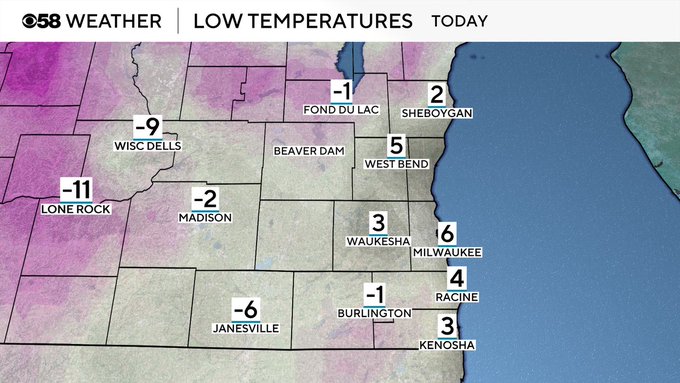
It was definitely a cold start to this Thursday morning with low temperatures many locations inland into the negatives. This afternoon we don't get much warmer with high temps barely getting into the teens and feels like temps through this afternoon staying into the single digits.
 Image
Image
A southerly wind does return later today helping push in slightly warmer temperatures for the end of this work week. Temps will hold into the mid to upper 20s through the weekend, which are still about 10-15 degrees below average for this time of the year.
This colder weather does lead to a small chance for some snowfall tomorrow. Light snow looks to fall starting in the afternoon mostly north and then become scattered as we head through the evening. Flakes should wrap up around bedtime and then we turn quiet to start the weekend.