Air Quality Alert holds through tonight; hot to start the week

Canadian wildfire smoke has once again mixed down to our surface creating smoky conditions for pretty much the entire day today. An Air Quality Alert will remain in effect until the lunch hour tomorrow, as another round of thick smoke is likely to hold through tonight. Conditions will improve by tomorrow, and we'll have plenty of sunshine to start the new week with high pressure taking control of our weather.
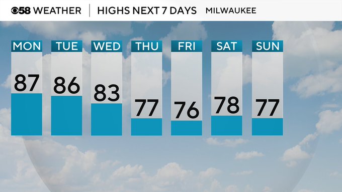
Low pressure is beginning to develop out to our northwest, and out ahead of that system a warm front will begin to lift tomorrow. This will help push in a light southwest wind, bringing in plenty of heat and humidity to start the new work week! Expect highs to be in the upper 80s for many, with feels like temps at least into the low 90s.
Heat and humidity could allow the chance for some small passing sprinkles to develop tomorrow afternoon and again into Tuesday, but the real chance for rain and thunderstorms will develop by Wednesday and again into Thursday. As of now, things look to stay away from the severe threshold, but the heat and humidity could potentially help fuel a few stronger storms these days.
Quiet by Friday with sunshine returning to finish the work week.
