Significant snow and blizzard conditions possible Thursday and Friday


Now we get ready for a major winter storm for the end of the week. By Wednesday afternoon the clouds have returned with snow showers beginning Wednesday evening. Snow will be steady at times Wednesday night into Thursday morning with some snow covered roads for the Thursday morning commute. The snow will pick up during the day on Thursday with steady snow expected in the afternoon and evening. Schools still in session Thursday will need to be watched for cancelations or early dismissals.

A winter storm watch has already been issued for Thursday morning through Saturday morning. This watch will be upgraded to an advisory, winter storm warning or even blizzard warning depending on what the biggest threats will be.

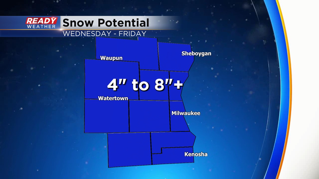
It's still a little too early to talk exact snow totals. Typically, with these big winter storms we see weather models show a crazy amount of snow 5-10 days before a storm then get more reasonable when we get closer to the snow falling. That is what we are seeing with this storm. Weather models are now showing less than half of the crazy totals they had over the weekend. That being said, this will still be a significant snow for most of the area. Everyone shaded in the blue in the map below has the potential to see over 4" of snow. Notice that the entire state of Wisconsin has that chance and so do most of our surrounding states. If you are traveling expect snow no matter where you go!
Traveling on Wednesday is still good to go. Thursday will be difficult but might not be terrible in the morning and much worse in the afternoon and evening. Friday is the day to avoid. Blowing heavy snow will make travel nearly impossible even for a 20 or 30 minute drive. I would change plans if you are supposed to drive or fly on Friday.

The word "blizzard" has been talked about a lot as we get closer to this storm. Part of southeast Wisconsin could be under a Blizzard Warning by Friday. To get a true blizzard you only need two criteria that have to last for 3 hours or longer. 1. Sustained winds or frequent wind gusts over 35 mph. 2. Visibility under a quarter mile of visibility. With all the development in Milwaukee County and the surrounding area it's very difficult to satisfy true blizzard criteria but open farmland and more rural areas have a much better chance for seeing a blizzard.

After a light wind Tuesday and Wednesday we will see the breeze pick up on Thursday. Friday will be the windiest day, thus the chance for a blizzard, with gusts to 50 mph. Saturday is still very windy with gusts to 40 mph and a blowing snow still likely.

Download the CBS 58 Ready Weather app to track forecast changes, new advisories and warnings, and see where the snow is.