Rain, Storms On The Way... Update
Your CBS 58 Weather Team continues to track strong to severe storm potential for both Thursday and Friday nights. Until then, sunny and unseasonably warm weather will continue across the area. High temps today soar to at least 80° for the third time this week and ninth time this month. Expect another warm day Thursday ahead of a cold front that starts moving southeast across the state.
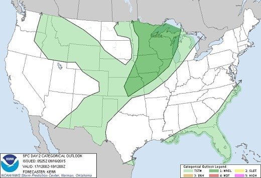
By Thursday night this front is forecast to reach Central Wisconsin. The leading edge of this cool air will undercut the warm air forcing it to rise and creating a line of thunderstorms. Some of these storms will be capable of heavy rain, large hail and gusty winds. The Storm Prediction Center has highlighted Wisconsin in the "Marginal" risk area for severe thunderstorms. This is the lowest level of severe weather risks and implies severe storms are expected to be limited in organization and intensity... we're not expecting a major outbreak.
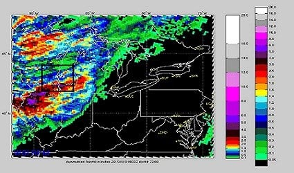
These storms should clear the area by Friday morning, but a second round is expected Friday night. The image below shows the combined total rainfall for both rounds. It's difficult to see, but the area in the square is most of Southeast Wisconsin. Rainfall totals range from around .30" in Fond du Lac and Sheboygan Counties to more than 2" near the Illinois border.
We will continue to monitor conditions leading up to and through these two weather events. As it stands now, the rain should end by early Saturday morning, but temps will be more Autumn-like with highs in the 60's Saturday and Sunday!
