


Sunday Midday Update August 18, 2019

We are still waiting on a cold front to move through early this evening. Until then, we are fair game for scattered showers and storms, likely staying below severe limits. We’re hearing of many downed trees in Kenosha County. If you have any storm photos you’d like to share, please send them to [email protected].
Updated: 8:30 a.m. August 18, 2019
The severe threat for Sunday morning has ended. Strong storms did push through areas along and south of I-94 to start Sunday with downpours and strong wind. There was a thunderstorm damage report out of Waukesha of a couple trees down.

A severe thunderstorm warning was issued for eastern Kenosha County around 8:15 a.m. There was a report of wind gusts in Pleasant Prairie of 52 mph.
Steady rain will linger through mid to late morning in most communities, but the majority of Sunday afternoon looks dry.
------
Updated: 7:30 a.m. August 18, 2019
A line of strong storms is currently moving across Southeast Wisconsin, especially across our southern communities. As of 7:30 a.m. nothing is severe as this line moves through but wind gusts are 30-40 mph. The line is moving quickly and should be around Milwaukee, Racine and Kenosha near 8 a.m.
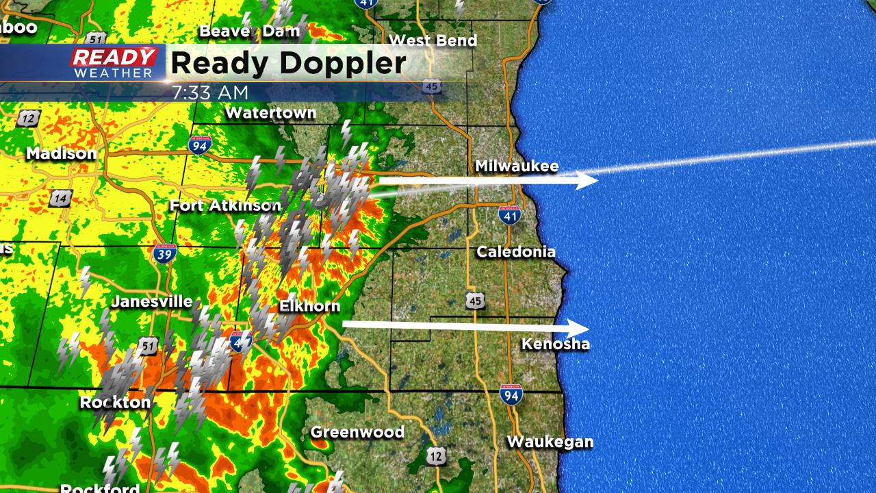
A severe thunderstorm watch remains in effect through the rest of the morning. After the initial storms push through we could see steady rain linger through most of the morning before a mainly dry Sunday afternoon.
------
Updated: 6:30 a.m. August 18, 2019
The National Weather Service has just issued a Severe Thunderstorm Watch until 1 PM for most of southern half of the viewing area. Large hail, damaging wind, and heavy rain are all possible. And after the morning round of storms, a few more are possible late in the day and into the evening as a cold front moves in from the west. Stay tuned to the CBS 58 Ready Weather team for further updates.

------
Updated: 4:30 p.m. August 17, 2019
Now it looks like the bigger push of storms will be Sunday morning, especially between 8 and 11 am as a warm front tries to lift north. There is still the chance for a shower or storm later in the day as a cold front works in from the west. The biggest threats will be heavy rain, gusty winds, and hail. There is a "marginal" risk of severe weather for most of us (except north of Milwaukee).


There's another chance of storms later Tuesday afternoon and evening with yet another cold front and then it really cools off for the middle of the week. Highs then only in the 70s with lows in the 50s.
______________________________________________________________________________________________________________
Milwaukee (CBS 58)—Look for an uptick in both heat and humidity today with highs in the 80s.
The chance of showers and storms really goes up overnight to do early Sunday morning as a warm front lifts to the north.
And then we have another risk of showers and storms Sunday morning into the early part of the afternoon as a cold front comes in from the west.
The biggest threats with the storms will be damaging wind and larger hail.
A good chunk of the area is in a “marginal “ risk of severe weather.
There’s also a “slight” risk of severe weather for western parts of Walworth County. Again, this is primarily an overnight event.