Mid-Morning Update: Winter storm warning in effect until noon with light wintry mix


Updated: 9:36 a.m. Feb. 23, 2023
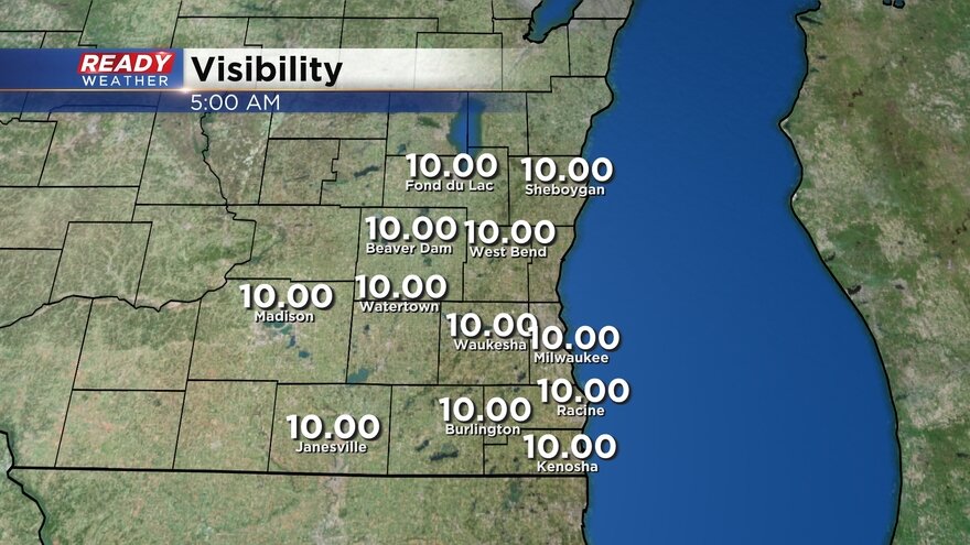
Some moderate drizzle is still falling across southeast Wisconsin. Some of this drizzle is freezing causing a glaze of ice. Other areas where temperatures are above 32* are just seeing wet conditions with some melting. Visibility is the best way to see who is getting the heaviest drizzle and light wintry mix.
Here's a visibility graphic that will update with time:
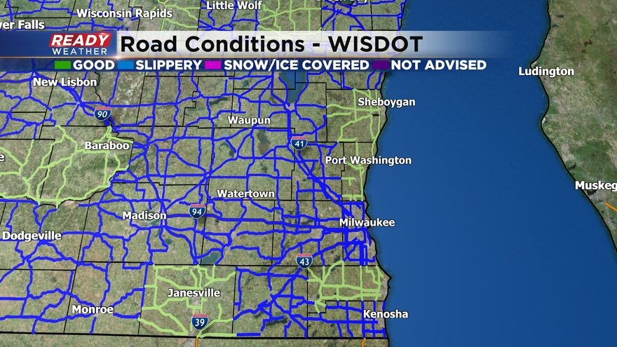
Road conditions have slowly improved this morning but most roads in southeast Wisconsin are still reported as slippery. They likely won't get into good driving conditions until the wintry mix ends around midday. Some flurries are still possible this afternoon.
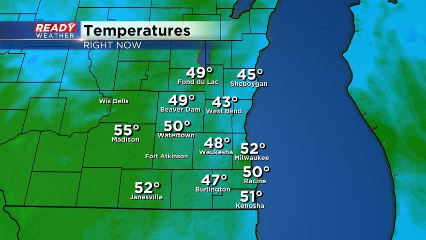
Temperatures will slowly warm during the day with highs Thursday afternoon in the middle 30s. Temps rising above 32* will allow for melting and easier clean up and reduce the chance for more ice.
Here is a temperature map that will update with time:
------
Updated: 7:17 a.m. Feb. 23, 2023
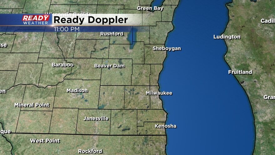
Some light lingering freezing drizzle or snow flurries are still flying this morning but accumulation the rest of the morning will be fairly light.
Here's a radar image that will update with time:

Road conditions are slowly improving with most major highways and freeways being reported as slippery stretches but some snow covered roads are still there. Side roads and neighborhood roads are in terrible shape so take it slow this morning.
Here's a DOT map of road conditions that will update with time:

------
Posted: 4:46 a.m. Feb. 23, 2023
The heavy wintry mix of sleet, freezing rain and snow is done but there is still some lingering wintry mix Thursday morning. Another inch of snow and sleet is possible in northern counties through the morning hours with a glaze of ice possible in southern counties. A few lingering flurries may be possible Thursday afternoon and evening but no additional accumulation is expected after noon.
Here's a radar image that will update with time:
There have been some adjustments to the weather headlines. The ice storm warning in Walworth, Racine and Kenosha Counties has been canceled. It has been replaced by a winter weather advisory that also includes Jefferson, Waukesha and Milwaukee Counties until 9 AM for the potential for a glaze of ice with freezing drizzle.
A winter storm warning remains in effect for northern counties including Fond du Lac, Sheboygan, Dodge, Washington and Ozaukee Counties until Noon for an additional inch of sleet and snow.

Roads so far Thursday morning are garbage. Many neighborhood and side roads have not been plowed and although main roads have been plowed they are still mostly snow covered. Even freeways are still slushy and snow covered. Expect conditions to improve during the morning commute. As of 5 AM, DOT is reporting either snow/ice covered or slippery across all of southeast Wisconsin.

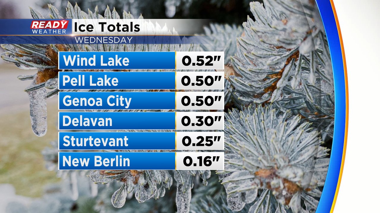
Snow/sleet and ice reports are still rolling in and expect them to change throughout the morning. Highest snow totals happened in Fond du Lac and Sheboygan Counties where 8-12" of snow fell. Many parts of Dodge, Washington and Ozaukee Counties saw 4-8" with 1-4" in Waukesha and Milwaukee Counties and nothing in southern areas where it was all ice.

Ice reports show a half inch of ice in Walworth, Racine and Kenosha Counes. South of I-94 also reported over a tenth of an inch of ice in spots.
Unfortunately we aren't done with the snow machine. Another round of light snow is expected Friday evening with up to inch of new snow possible. Thankfully this time we don't have to deal with any sleet or ice.

Download the CBS 58 Ready Weather app to track the lingering morning mix and see the latest reports.