10 PM Update: Storms transitioning into more of a heavy rain threat


Updated: 10:00 pm August 27, 2021:
The severe storms near Green Bay and far SW WI have weakened over the last two hours with no severe storms out there at this time.
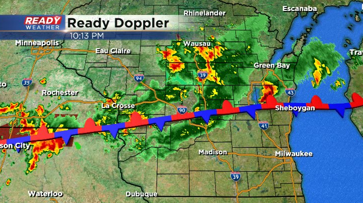
No additional watches are expected overnight as storms transition into more of a heavy rain threat, mainly across central WI along the stalled frontal boundary. However, we can't rule out an isolated strong wind gust or two in storms.
---------------------------------------------------------------------------------------------------------
Updated: 8:00 pm August 27, 2021:
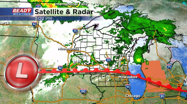
We're continuing to watch the area of severe storms in NE Iowa that are about to cross into southwest Wisconsin. These are now beginning to track southeast and will likely fall apart before reaching southeast Wisconsin.
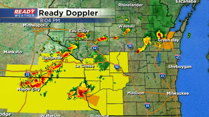
The additional storms firing behind this severe cluster in north central Iowa are tracking northeast. The better energy to fuel storms is focused in this area into west central Wisconsin, and north of the warm front closer to Green Bay. Most storms will remain in these locations overnight, but a few may still clip our far northwestern spots.
----------------------------------------------------------------------
Updated: 5:45 pm August 27, 2021:
The severe storm in Washington and Dodge counties has weakened below severe limits. This cell is slowly tracking east into Ozaukee county with heavy rain and plenty of lightning. Our attention now turns to the west where a Tornado Watch has been issued through 11 pm.
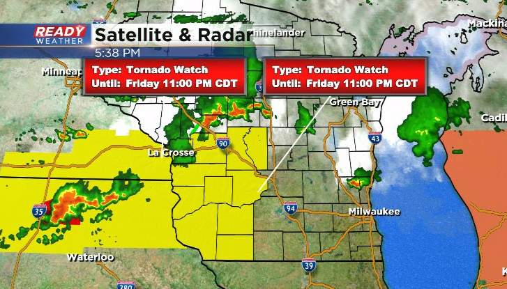
The tornadic cluster of storms in Iowa is expected to track eastward into this evening, but the better forcing to keep these storms going will be pushing into NW WI and eastern Minnesota. So the current expectation is these storms would weaken the closer they get to southeast Wisconsin, but we will keep an eye on them through the evening.
-------------------------------------------------------------------------------------
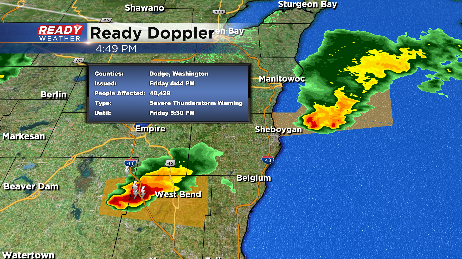
Updated: 4:45 pm August 27, 2021:
The severe cell in Sheboygan county has moved offshore so the warning has been cancelled. We are watching another severe storm into Dodge and Washington county. Officially a Severe Thunderstorm Warning is in effect for Washington and Dodge until 25 mph. This one is moving east around 25mph and could contain wind gusts to 60mph along with quarter size hail.
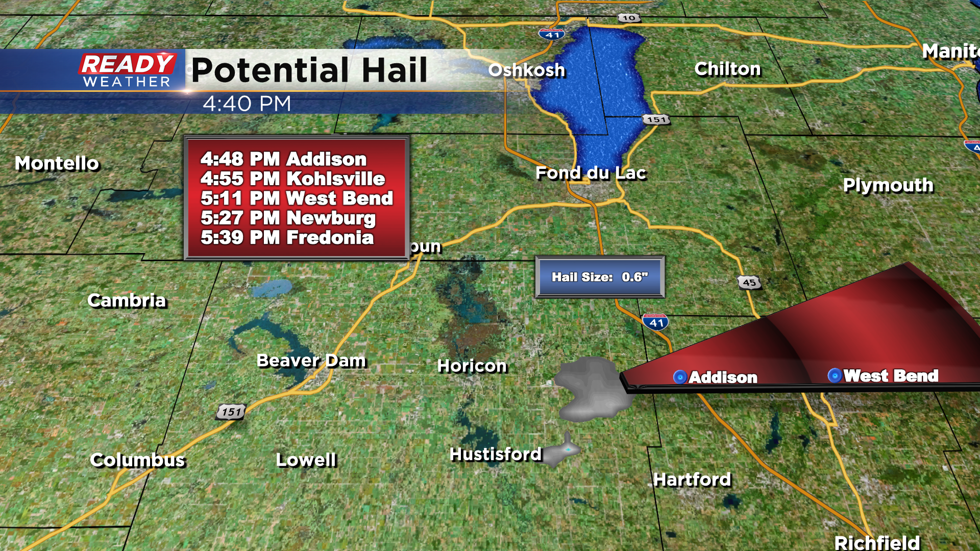
You'll want to head indoors if you're in line of this storm as it also contains frequent lightning.
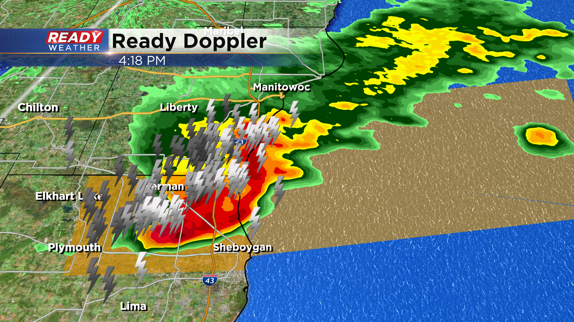
Updated: 4:20 pm August 27, 2021:
A Severe Thunderstorm Warning is in effect for Sheboygan county until 5pm. The primary threat is 60 mph wind gusts. The cell is moving east about 20-25 mph. As you can see torrential rain is occurring with frequent lightning. It's also possible some small hail is contained within this cell.
Updated: 3 pm August 27, 2021:
A few isolated storms have popped up near Fond du Lac and Dodge counties this afternoon. These storms are currently below severe limits, but may produce gusty winds up to 40 mph and small hail.
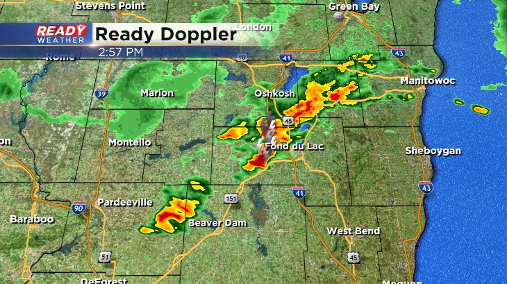
Additional storms are expected to fire this evening into tonight as a warm front continues to lift northward through the state. This front is currently draped across the northern parts of our area.
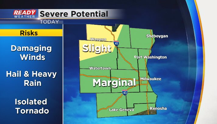
Storms are expected to fire near the front, giving our northern communities the best chance at the storms and heavier rainfall. With the proximity to the front, there is a isolated tornado risk in our northern counties of Dodge, Fond du Lac, and Sheboygan. Damaging winds and hail will be the primary threats in storms. A Slight Risk (2 of 5) remains in place for Dodge and Fond du Lac counties with a level 1 Marginal Risk elsewhere.
Although we're seeing a few storms now, the main action will develop this evening into tonight before weakening and lifting northward early Saturday morning.
---------------------------------------------------------------------------------------------------
Updated: 12:30 p.m. August 27, 2021
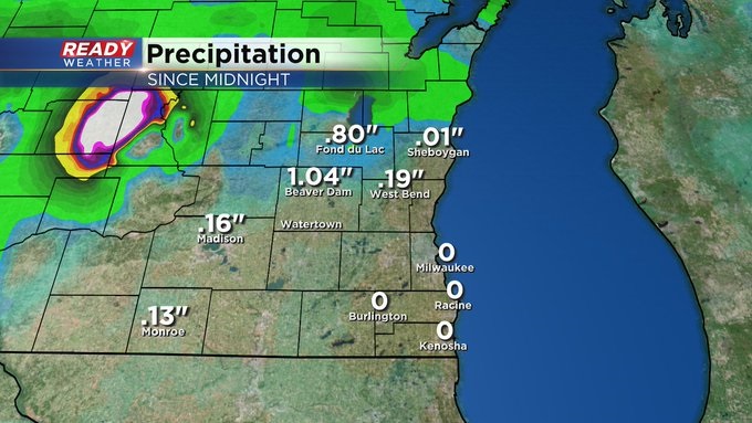
Heavy rain and storms pushed through parts of Dodge, Fond du Lac, and Sheboygan Counties late this morning. Everything stayed below severe limits. But we did see rainfall totals more than an inch for some locations and sporadic damage in Fox Lake. Parts of Fond du Lac and Dodge Counties remain under a slight risk of severe weather this afternoon into the evening. Everyone else will be under a marginal risk.
_____________________________________________________________________________________________________________
Updated: 10:36 a.m. August 27, 2021
A line of strong thunderstorms has just entered our viewing area mainly north of I-94. Some gusty wind to 45 mph along with small hail and lighting is possible. Lighting strikes over the last 15 minutes have numbered over 250. The storms are expected to move ENE over the next two hours.

After this round of thunderstorms a few more may be possible later this afternoon and evening. Once again, areas north of I-94 have the best chance to see storms.
------
Posted: 7:35 a.m. August 27, 2021
A majority of the rain the last two days has missed our local area with just a handful of isolated showers. That trend could hold true for Friday into Saturday morning but there's also a chance that some of us see some decent storms. As of 7 AM Friday there's a lot of rain across Wisconsin just not in our local area. Most of the rain and storms have stayed west and north of Madison where parts of central Wisconsin have seen beneficial steady rain. A few scattered showers and storms will be possible here locally for most of Friday through the afternoon/evening and into Saturday morning. Currently the best chance for rain looks to be north of I-94 and especially in Dodge, Fond du Lac and Sheboygan Counties.

Any storms that do form could drop a half to full inch of rain but those that just see a few showers will only get a tenth or two of rain or even less.

With all of the heat and humidity still in place there's a lot of energy in the atmosphere. Any storms that do form or reach southeast Wisconsin could be on the stronger side. High wind and some hail along with downpours would be the main risks.

Temperatures on Friday will stay in the middle 80s for most but some areas near the IL border could get close to 90. The big time heat really starts to return Saturday and Sunday with highs in the low 90s both days. A cold front will roll through on Sunday (bringing another chance for rain and storms. That cold front will cool us down into the upper 70s to around 80 for next week.

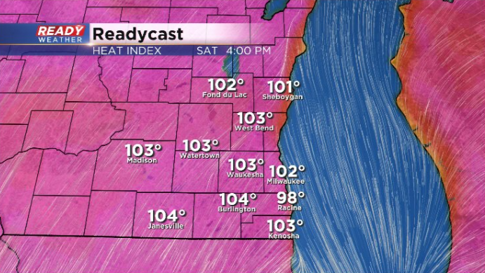
The humidity is going to stay high with dew points in the low to middle 70s through the weekend. Very similar to the high humidity we've had over the last few weeks. Factoring in the humidity the feels like temps over the weekend will likely pass 100. Saturday looks like the worst of it and a heat advisory is possible. Heat indices then could get as high as 105.
Download the CBS 58 Ready Weather app to track the chance for storms and big time heat.