Friday Mid-Morning Update: Lingering lake effect for Friday


Updated: 9:04 a.m. Feb. 25, 2022
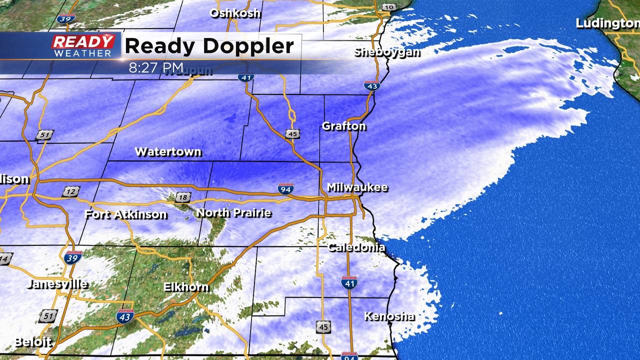
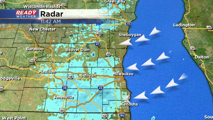
We're seeing some lake effect snow showers come and go for many of our lakeside communities like Milwaukee, Racine and Kenosha. The potential for lake effect will last through the early afternoon. If we do see some moderate bands of lake effect snow we could get a half inch or 1.5" of additional snow.
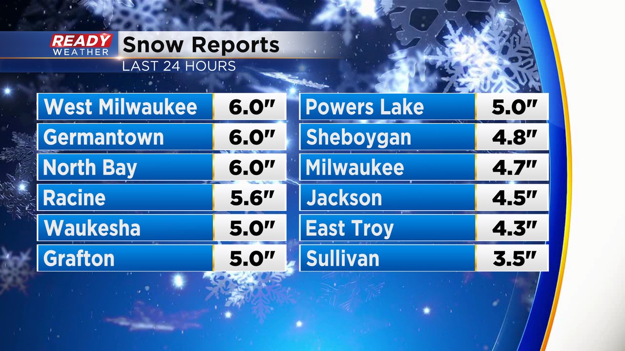
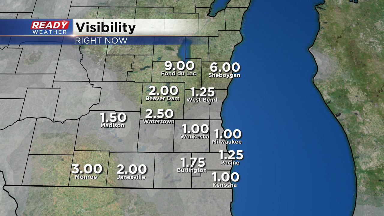
The latest snow reports show a few 6" reports showing up in West Milwaukee, Germantown, North Bay and Tosa. All of southeast Wisconsin got 3-6" of snow.
This will be the last update for this winter storm.
------
Updated: 5:49 a.m. Feb. 25, 2022
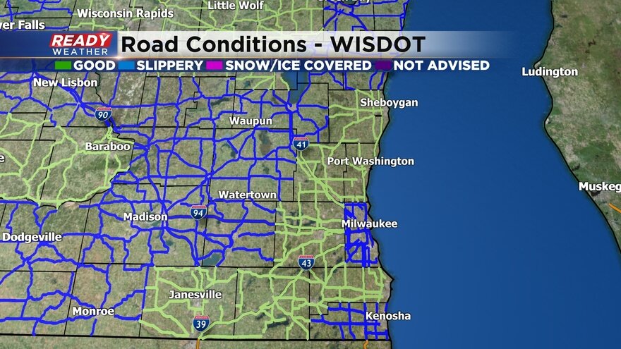
The steady snow came to an end between 1-3 AM Friday morning from west to east. Road conditions have been improving slowly this morning with slippery and snow covered reported across most of southeast Wisconsin. Here's a look at current road conditions courtesy of DOT:
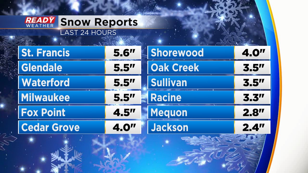
Snow reports are starting to come with most of southeast Wisconsin seeing between 3-6" of snow. This is a super fluffy snow and very easy to shovel but there is still a lot of it with most of Milwaukee County seeing 5-6" of snow.
We're also still watching the potential for more lake effect. A lake effect band has impacts Sheboygan this morning but the bulk of that band is just east of the shore over Lake Michigan. If lake effect does form it could last through the afternoon. Some additional accumulation is possible.

------
Updated: 11:34 p.m. Feb. 25, 2022
Snow will continue to be a problem through 3 am. Early Friday morning, dry air will start to erode the snow showers for the morning commute. Roads will be slick and hazardous, especially side roads and secondary roads.
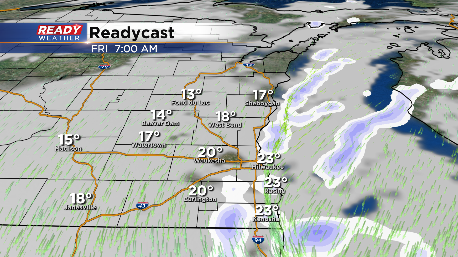
Even though most of the snow will be done falling by daybreak, roads will be a problem to start the morning. Lingering lake effect snow showers will be possible through the morning along the lakefront. Most areas will have 2" to 5" of new snow. Lake enhancement will create locally higher amounts near the lakefront.
______________________________________________________________________________________________________________
Updated: 8:30 pm Thursday, February 24th:
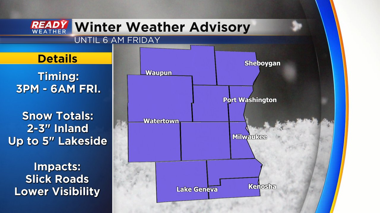
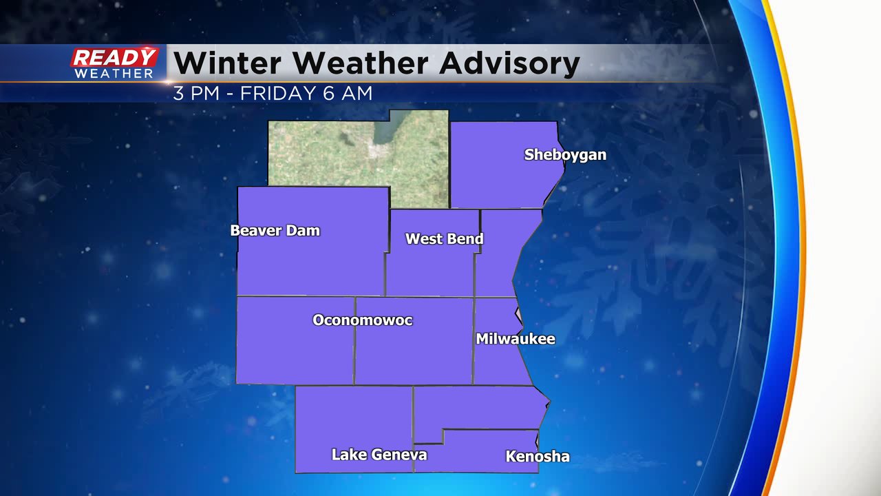
The winter weather advisory is in effect for the entire area until 6 am. Visibility has dropped where the heaviest snow is falling.
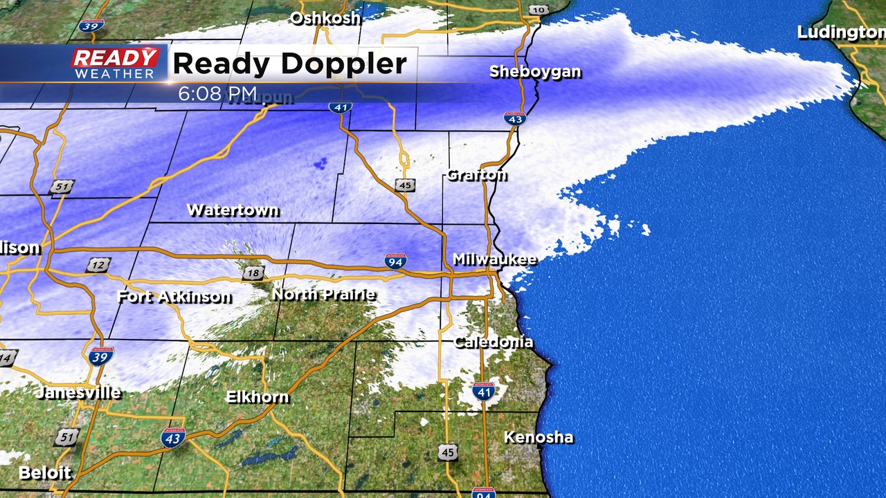
Steady snow is falling across the majority of the area. Unfortunately, with temperatures in the 20s, roads have become slick and hazardous. Side roads are even worse. Please use caution. The heaviest snow for now is falling along and north of 94. Lake enhancement has created heavier bands of snow tonight.
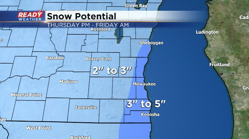
Snow will gradually come to an end between 3 am and 7 am. Most areas will have 2" to 4" of snow with up to 5" lakeside.
______________________________________________________________________________________________________________
Updated: 5:30 pm Thursday, February 24th:
Snow has been slow to arrive for most of the area this evening; however, that will change over the next couple of hours. Snow is already coming down across Fond du Lac and Sheboygan counties.
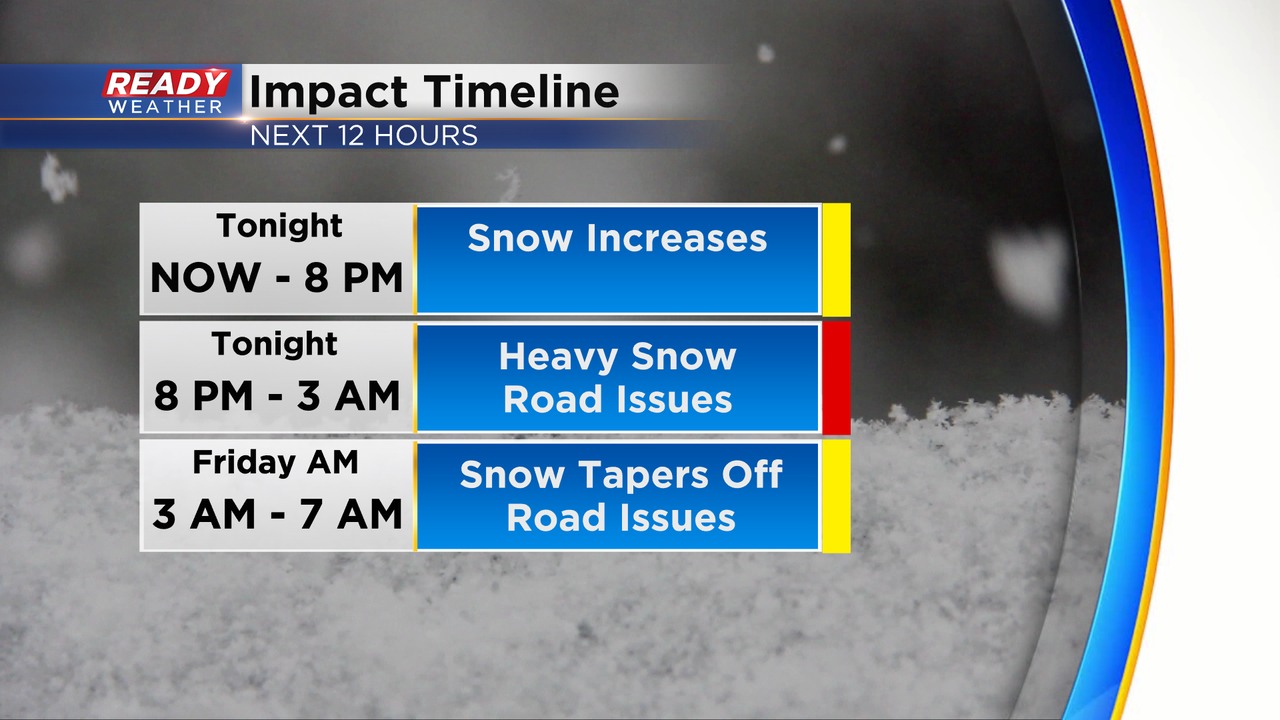
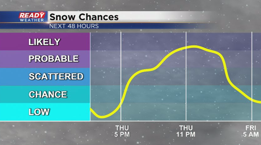
Between 8 pm and 3 am expect the heaviest snow to come down. Roads will become an issue along with lower visibility. Snow will taper off between 3 am and 7 am. The morning commute looks slick and hazardous.
______________________________________________________________________________________________________________
Updated: 3:30 pm Thursday, February 24th:
All of our counties have been added to the winter weather advisory. The light lake effect snow we had for most of the morning has tapered off early this afternoon.
Snow will start to develop between 4:30 pm and 6:30 pm; however, the effects won't be until later this evening. The evening commute should be ok. The heaviest snow will occur from 9 pm until 3 am.
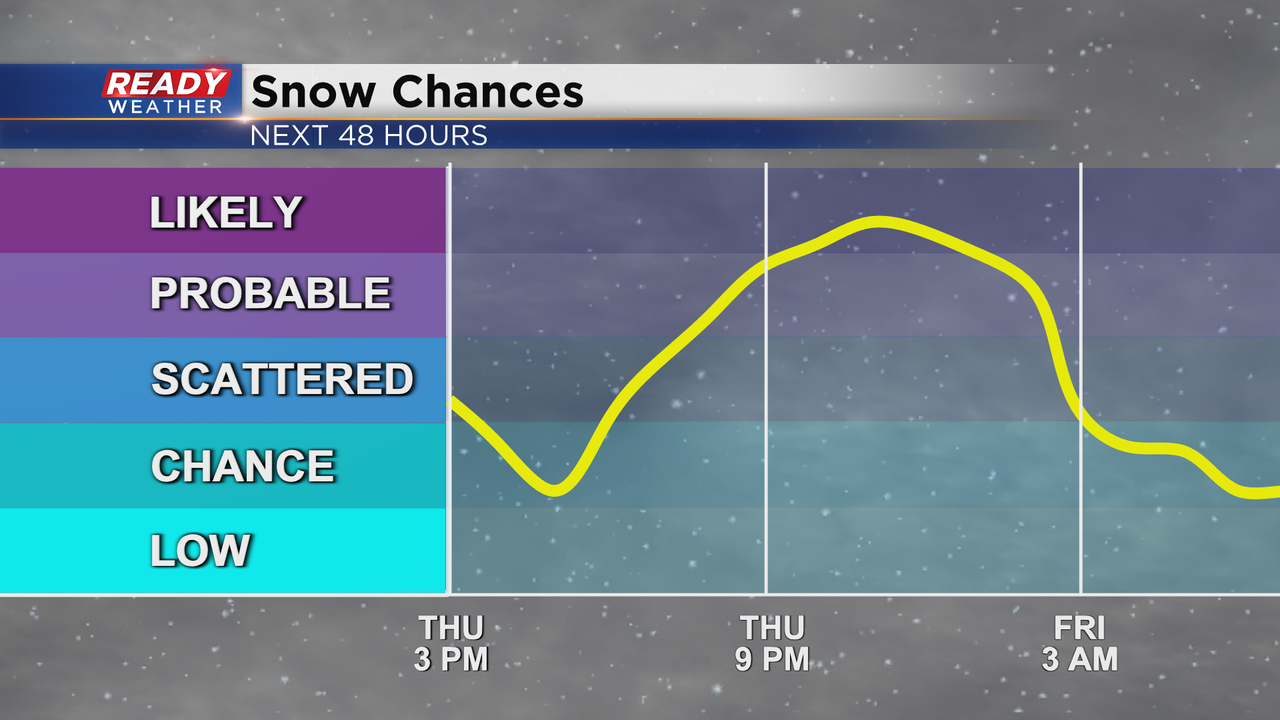
This snow is still developing back to our southwest. The previous snow total forecast remains on track, but Fond du Lac has been added to the Winter Weather Advisory with the rest of southeast Wisconsin.
----------------------------------------------------------------------------
Updated: 11:45 am Thursday, February 24th:
Light lake effect snow and flurries continue across southeast Wisconsin as winds remain from the ENE. This light snow has had a hard time accumulating thanks to the lingering salt on the ground from the ice storm earlier this week.
While these flakes may linger into the afternoon, no more than a dusting is expected from them. The main round of accumulating snow is still on track to move in around sunset with a majority of the accumulating occurring this evening into tonight.
Most of the area will pick up 2-3" of fluffy snow by Friday morning, but lake enhancement could boost lakeside totals up to 5".
-------------------------------------------------------------------------
Updated: 8:52 a.m. Feb. 24, 2022
Lake effect snow is still ongoing this morning. A few areas have reported a dusting or a few tenths of an inch of snow. This has led to some snow covered sidewalks and side streets so take your time traveling. The lake effect should wrap up by late morning.
The next round of snow is taking shape Thursday morning in the central US and will move northeast through the rest of the morning and afternoon. Snow starts to fall locally after 5 PM. Expect worsening road conditions during the evening commute. Roads will be snow covered at times tonight into early Friday morning. Visibility could also be reduced with the moderate bands of snow.

------
Posted: 6:14 a.m. Feb. 24, 2022
We are waking up to some light lake effect snow showers Thursday morning. Some of it is accumulating to a dusting or few tenths of an inch. Watch your step on sidewalks that were already icy before this lake effect arrived and with a fresh coating of snow will be even more slippery. The vast majority of roads are still in pretty good driving conditions. Check out the current driving conditions here:

The lake effect should wrap up by mid-morning with mostly cloudy and dry conditions arriving from late morning through most of the afternoon. The next round of snow arrives during the evening commute and lasts through early Friday.

A winter weather advisory has been issued for almost all of southeast Wisconsin, except Fond du lac County. The advisory starts at 3 PM Thursday afternoon and lasts until 6 AM Friday morning.
The snow Thursday evening and night will be moderate at times and easily accumulate with cold temperatures. The majority of southeast Wisconsin will see between 2-3.5" of new snow. The question mark is how much lake enhanced or lake effect snow arrives. If it does some lake effect totals could push towards 4" or 5" of snow but even most lakeside areas will be closer to the 3" number than 5".

Download the CBS 58 Ready Weather app to track the storm.