Flood warnings continue with more rain possible Sunday into early Monday


Updated: 6:00 p.m. Aug. 10, 2025
This afternoon has featured plenty of dry time. This is something we desperately needed. Unfortunately, we aren't out of the woods yet. Another round of showers and storms is forecast between 9 pm and 12 am.
Storms are expected to fire across western Wisconsin this afternoon and move east. They will not be like last night. They are expected to weaken as they move east.
Here's a radar image that will update with time:


There are currently no flash flood warnings in effect, but river flood warnings continue to come in. Many river gauge locations across southeast Wisconsin saw record high levels or at least close to it. Most of those rivers remain in moderate or major flood stage and continue to stay high. As water continues to filter into these rivers, creeks and streams we will continue to see them stay high for a few days even though flood warnings only currently go through Sunday evening in most areas.
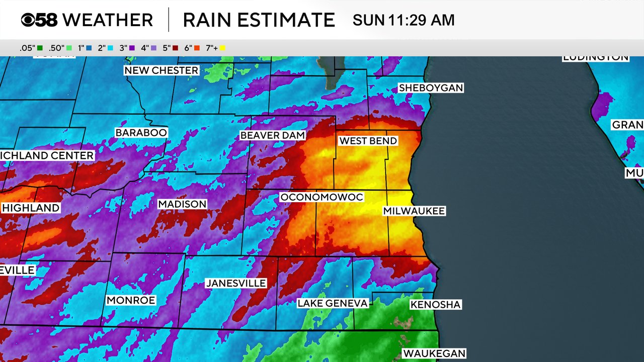
The flood event we experienced Saturday evening/night was a 500-year flood. That means that the chances of flooding like this of occurring is once every 500 years. In some areas rainfall rates and totals Saturday night got close to a 1,000-year flood! When you look at a map of estimated rainfall you can see where the heavy rain bullseye was - a wide area over Milwaukee, Waukesha, Washington and Ozaukee Counties.
Stay with the CBS 58 Weather app for any more flash flood warnings and tracking more rain Sunday and Monday.
------
Updated: 1:00 p.m. Aug, 10, 2025
After the historic flooding from Saturday into Sunday morning, we are tracking scattered showers and some embedded thunder. The storms that have developed across northern Illinois this morning have weakened north with the lack of instability. Unlike yesterday when the temperature was in the 90s, the overcast sky is limiting any explosive development. Rainfall rates of 0.25" to 0.50" an hour are more likely.
Regardless of rainfall rates, any additional rain will create more issues with flooded roads and rivers. Plan on scattered rain to continue this afternoon and evening before coming to an end overnight.
------
Updated: 10:35 a.m. Aug. 10, 2025
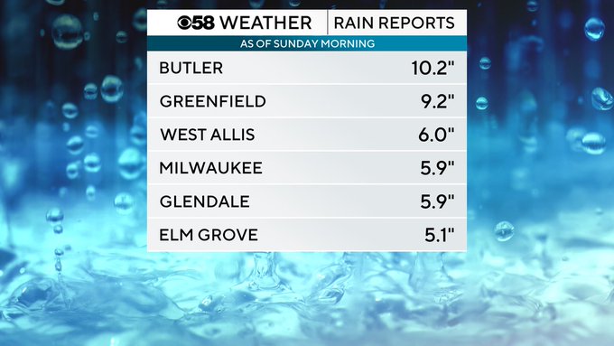
Saturday's rain was historic. Officially in Milwaukee at the airport, which is the official climate station for the city, they picked up 5.74" of rain which shatters the daily rainfall record for August 9th. The old record was over four inches lower at 1.64" set 65 years ago in 1960.

The nearly 6" they picked up at the airport was also the second highest rainfall total for one day in Milwaukee's weather record history. The record rain in one single day is 6.81" set on August 6,1986.

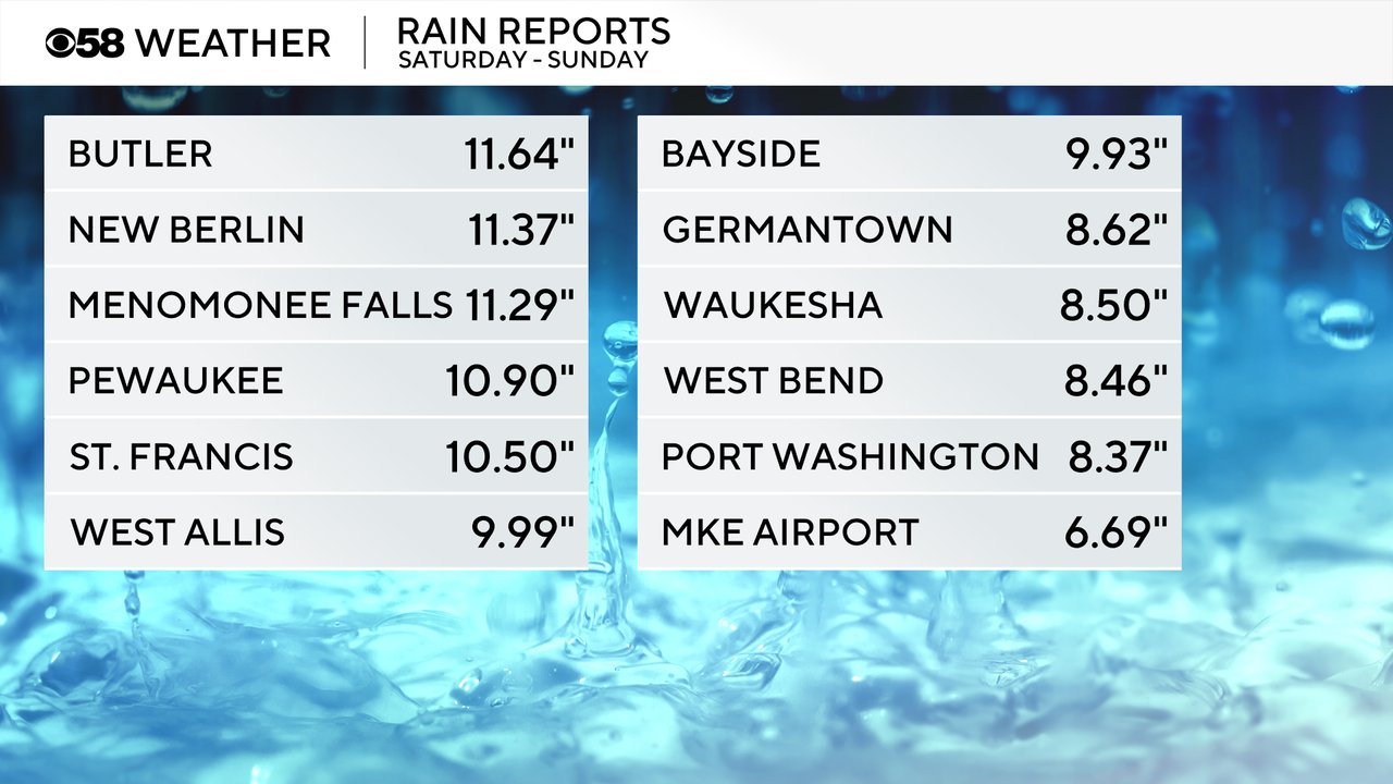
The record rainfall in Milwaukee at the airport was enough to cause flooding, but it wasn't as much as some areas. Other parts of Milwaukee, Waukesha, Ozaukee and Washington Counties picked up 6-12" of rain. Communities around Butler, Menomonee Falls saw the highest reports with nearly 12" of rain.
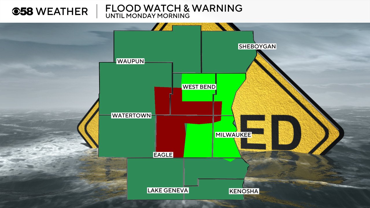
Flood alerts continue Sunday morning. A flash flood warning (dark red on the map below) remains in effect for parts of Waukesha, Milwaukee, Washington, Ozaukee and Dodge Counties until Noon. A flood warning (light green on map below) is also in effect for most of Milwaukee, Waukesha, Ozaukee and Washington Counties until 7 PM Sunday. In addition, all of southeast Wisconsin remains under a Flood Watch (dark green on map below) until Monday morning.
Unfortunately, we are not out of the woods yet and any storms or heavy rainfall, even if brief, on Sunday will quickly cause flooding conditions. Make sure to download the CBS 58 Weather app to get alerts if more flash flood warnings are issued and to track the rain and storms with the interactive radar.
------
Posted: 7:41 a.m. Aug. 10, 2025
After accumulating nearly a foot of rainfall overnight, showers and thunderstorms are continuing this morning. We are in a Level 1/5 risk to see stronger storms to wrap up this rainy weekend. Gusty winds are also a possible outcome today.
A flash flood warning has been issued for Waukesha, Washington, Ozaukee, and Milwaukee counties until 11am. Rain is coming down at a rate of about 1-1.5" per hour which would lead to the accumulation of about another 1-2" to come through on top of what we have already seen for the rest of this morning in areas with a flash flood warning.
Otherwise, a flood warning is in effect for eastern Waukesha and Milwaukee counties until 11am today. The same result is possible like areas in a flash flood warning but just may take a tad longer to see major accumulation. A flood warning is also issued for RIVERS/AREAS NEAR THE LAKE in eastern Waukesha/Milwaukee counties until Wednesday at 5:30sih am. Bodies of water near the city have the potential to become high and overflow creating spots of flooding.
Otherwise, a flood watch until 7am for all other counties in our DMA. This just means the recipe is there to see heavy rain and flooding, but it is not happening currently.
Just expect scattered storms all day. Should turn drier, slowly, overnight, with patchy fog likely to start the day tomorrow.