Get Ready for More Midweek Precipitation
High pressure is giving us a chilly, dry start to this Primary Election Day. However, more changes are coming as soon as late in the day as low pressure begins to move in from the west, giving us a chance of wintry mix into the early evening, especially around and north of the Milwaukee metro. Then it all changes to rain by later Tuesday night. At least the first half of Wednesday looks wet as well, and then more showery weather takes over into the afternoon.
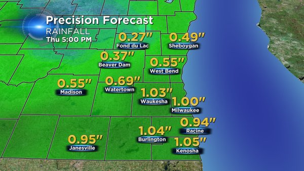
Rainfall amounts will be between a half an inch to an inch at least according to one reliable computer model we use. And yes, you guessed it, with more colder air coming for Thursday and Friday we face the chance of even more wintry mix, or mixy stuff, as I call it. I do see a warmup in sight by Sunday with highs around 50. But then it cools right back down into next week.
If you want to keep on top of the 10-day trend, make sure to download our free CBS58 weather app. You can see the radar, read our blogs, and send pictures to us. That's a lot you can do away from your home or computer.
