Busy weather weekend with increased rain chances, big drop in temps

-
2:30

CBS 58 Hometowns LIVE: Blades Golf in Germantown
-
1:54

Catholic Memorial High students pack sensory backpacks for City...
-
2:46

Wisconsin nurse returns home after weeks stuck in Israel amid...
-
1:05

Milwaukee mom receives 18 months of probation for locking 6 kids...
-
1:13

Beep baseball gives those who are blind and visually empowerment...
-
0:49

Milwaukee County Executive David Crowley delivers State of the...
-
0:49

Three Harbors Council Scouting America and Feeding America team...
-
2:33

Suspect dead after police-involved shooting in Village of Summit
-
4:39

CBS 58’s Theater Thursdays: ’Project Hail Mary’ and ’Tow’
-
4:01

Milwaukee Opera Theatre presents opera designed for babies and...
-
2:10

Precipitation chances take a break as snow melts fast
-
1:22

Juneau boys’ basketball team heads to WIAA Division 4 State...

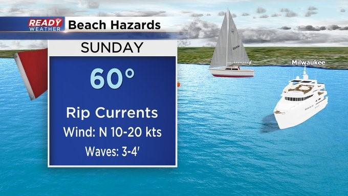
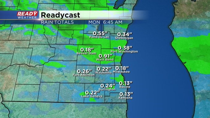
MILWAUKEE (CBS 58)--I know it's the weekend, and many of you don't want rain. But we're getting some. For what it's worth, a lot of it will fall overnight into early Sunday. A front will drop down from the north and trigger a few showers and storms by late in the day, especially north of I-94. Most of the precipitation should wrap up some point Sunday morning. Rainfall amounts will range between 1/4" and 1/2" for most.
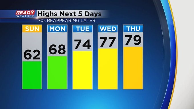
It'll turn sharply cooler into tomorrow, and the wind will stay high. In fact, there's a Beach Hazard Statement in place on Sunday for high waves and dangerous currents. Low pressure pivoting to the east early next week could trigger a few showers both Monday and Tuesday, and then a completely different system could pop a few showers and storms Wednesday afternoon into the evening.