
-
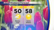
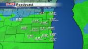
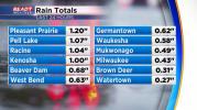
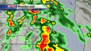
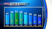
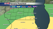
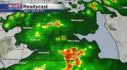 Multiple chances for strong to severe storms this weekend
-
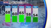
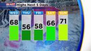
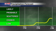
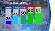
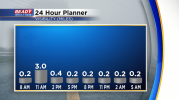
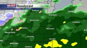
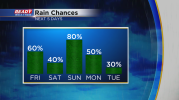 Rounds of rain and storms expected to end the week and throughout the weekend
-
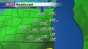
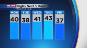
 Widespread freeze expected Thursday morning
-
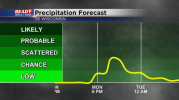
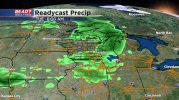
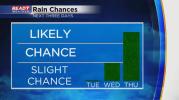
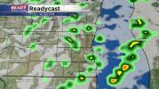 Scattered showers and storms expected Tuesday afternoon and evening
-
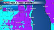
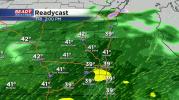
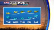 Don't plant yet! More frost and freeze conditions possible this week
-
 Mother Nature giving us a nice Earth Day before unsettled changes come with the forecast
-
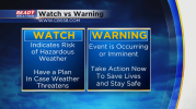
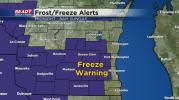 Freeze Warning issued for inland counties tonight
-
 Frost factor this coming week along with some rain chances
-
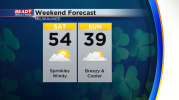
 Windy Friday then a chance for frost this weekend
-
 Another day of showers before a dry weekend
-
 A few more storms and showers possible Wednesday and Thursday
-
 Tornado Watch is canceled.
-
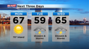
 Another beautiful day before showers and storms return
-
 Sunny to start the week, but rain and storms move in on Tuesday
-
 Sunny and even warmer weather expected on Sunday
-
 Severe Weather Awareness Week in Wisconsin
-
 Statewide tornado drill happening Thursday but showers are likely too
-
 Another glorious day as temperatures stay warm
-
 We stretch our nice weather out for a few more days but rain arrives Thursday
-
 Skies look to clear out in time for Monday's solar eclipse
-
 50/50 weekend weatherwise followed by some nice weather for eclipse viewing
-
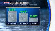 March stats are in after a wet and warm month
-
 Early Afternoon Update: Spotty rain showers continue through the afternoon
-
 Mid afternoon update: Patchy rain and snow to continue through the afternoon
-
 Snow is expected to arrive across the entire area overnight!
-
 No joke April delivers rain and then snow to kick off the month
-
 A cruel joke from Mother Nature as we start April
-
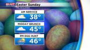 Showers for Easter but still plenty of dry time
-
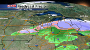
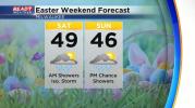 First of three rounds of rain for the holiday weekend arrives Friday evening
-
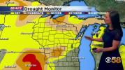 Weekly drought monitor reveals southeast Wisconsin in the best shape as wet March rolls on
-
 Drying out briefly after a soggy start to the work week
-
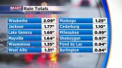
 Top 10 wettest March on record continues with more rain Tuesday
-
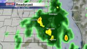
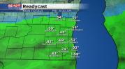
 Soggy start to the week
-
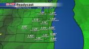
 A wet start to the week w/a variety of weather elements
-
 Done with one storm, another nipping on its heels
-
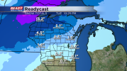
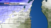
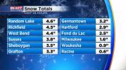
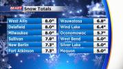 Snowfall has ended across the area! Looking back on some very high totals.
-
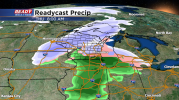
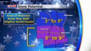 Winter weather advisory issued for heavy snow Friday
-
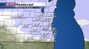
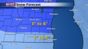 Accumulating snow returns by the end of the week
-
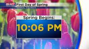 Mild for the first day of spring before another chill and the chance for snow
-
 Spring starts on Tuesday, but Mother Nature says 'not so fast'
-
 More like winter than spring as we start a new season on Tuesday
-
 A couple of seasons in this St. Patrick's Day weekend forecast
-
 Drying out for a while after a super soggy Thursday
-
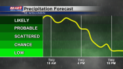 Rain is likely throughout Thursday
-
 Isolated showers possible Wednesday with a round of soaking rain and storms Thursday
-
 Another windy and warm day with rain chances arriving for the second half of the week
-
 Warm and windy to kick off the new work week
-
 Quiet, cool weather as we spring forward to Daylight Saving Time on Sunday
-
 Breezy Friday with scattered showers
-
 Another soaking rain on the way Friday
-
 More clouds Thursday ahead of a cold rain on Friday
-
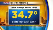 Meteorological winter goes into the record books as the warmest in recorded history
- Evening Update: Strong storms remains possible, but the overall risk is low.
-
 Rain and storms likely Monday evening into Monday night
-
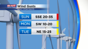 Sunday breezes bringing more warmth & fire dangers; Monday rain to follow
-
 Our quiet weather lasts through the weekend before the forecast turns unsettled
-
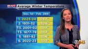
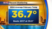 Record setting February comes to an end
-
 Leaping Over Weather Stats on This Day in Weather History
-
 Record-smashing warmth is long gone with a winter chill briefly returning
-
 Tornado Watch for Racine, Kenosha, and Walworth counties has been canceled.
-
 Sun to storms to snow in just a few days
-
 Quite the wild weather ride this week with sun, storms, and snow
-
 No stopping these crazy temp swings through next week at least
-
 Lake effect remains possible overnight for Racine, Kenosha, and Milwaukee counties.
-
 Strong cold front to bring brief drop in temps and a batch of snow showers on Friday
-
 Warm February weather
-
 Warmth is back and sticks around through the end of February
-
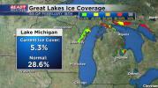 Measly Lake Michigan ice coverage as yearly trends show less ice
-
 A quiet Presidents' Day forecast extends into much of this coming week
-
 Deep freeze to start the weekend but more mild air on the horizon
-
 Coldest air in nearly a month returns to southeast Wisconsin
-
 Thursday Mid-Morning Update: Snow is over but wind is picking up
-
 Chance for accumulating snow increasing Thursday morning
-
 Mother Nature gives us reminders this week we're very much still in winter
-
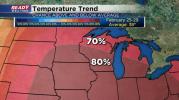
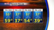 Recapping the records from this week and a look ahead at continued warmth
-
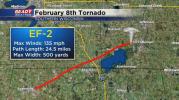 Everything you need to know about Thursday's historic February tornadoes
-
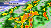
 Afternoon Update: Storms firing near the Mississippi River could be strong to severe this evening
-
 Midday Update: On both record and storm watch over the next couple of days
-
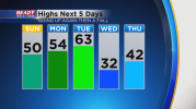
 The groundhog may have had it right -- 50 degrees coming our way very soon
-
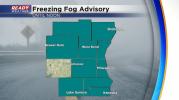 Rare freezing fog advisory in effect Monday morning
-
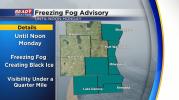 Evening Update: Freezing Fog Advisory issued for several SE WI counties through Monday morning
-
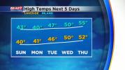 Nothing but warmer than normal temps for the next week
-
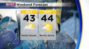 Chances for sun get better by the end of the weekend
-
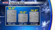 January goes into the record books mild and wet as we get ready for a longer February
-
 February starting like January is ending
-
 Sprinkles and flurries possible Tuesday but overall precipitation chances lacking
-
 Looks like our January thaw will extend right into February
-
 Breaking out of the fog and keeping the mild temperatures all week
-
 Low clouds, fog keeping us on the mild side of things
-
 Evening Update: Rain tapers off, but dense fog returns
-
 Dense Fog Advisory extended into the evening
-
 Shifting focus from wintry mix to rain showers the next couple of days
-
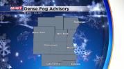 Dense Fog Advisory Issued Until 10 AM Wednesday
-
 Update: Winter Weather Advisory Issued for Tuesday
-
 Getting out of the deep freeze but heading into some wintry bouts of precip
-
 One more cold weekend to endure then temps take off
-
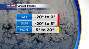
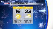 Wind Chill Advisory for some, along with a chilly weekend -- then warmer temps ahead
-
 Light, fluffy, accumulating snow returns for everyone Thursday night
-
 Cold gets a bit better but snow chances return
-
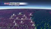
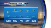 Cold air continues with dangerous wind chills through the middle of the week