Late Night Update: Last Push of Rain is Overhead


Updated: Friday, May 24th 10:45pm:
The cold front is pushing over the area as of now. A heavy line of rain is found along it.

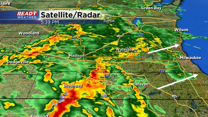
Updated: Friday, May 24th 5:45pm:
There's more rain and storm activity filling in.
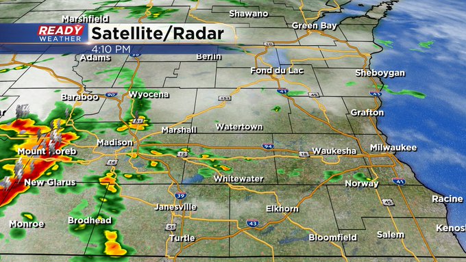
Updated: Friday, May 24th 4:00pm:
We're seeing a few cells pop up across the viewing area late this afternoon. Here's a look at Ready Doppler:
Updated: Friday, May 24th 2:00pm:
The first round of showers and storms has moved out over the lake, but we're keeping a close eye on the scattered storms in southwest Wisconsin.

Cloud cover is thinning across southern Wisconsin and northern Illinois, which is something we didn't want to see.

The more sunshine we get this afternoon, the more fuel we'll have for severe storms. Scattered storms may pop along the warm front between 4-6pm, posing a risk for tornadoes, damaging wind, and hail.

The more widespread areas of strong to severe storms will move through between 6-9pm. The amount of sunshine we get over the next few hours will determine how widespread the severe weather will be this evening.

-----------------------------------------------------
Updated: Friday, May 24th 11:02am:
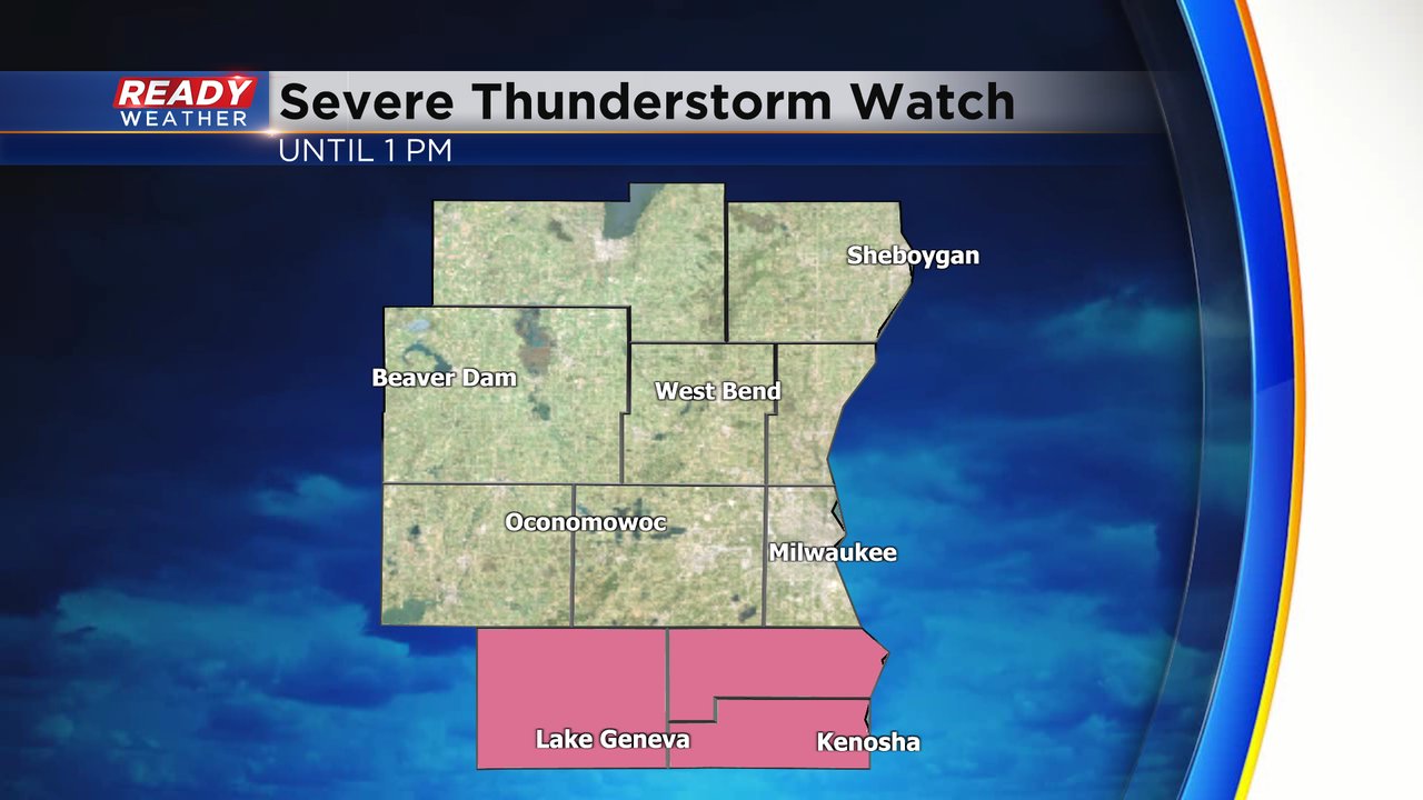
A Severe Thunderstorm Warning has been issued for portions of Waukesha, Milwaukee, Ozaukee, and Washington counties until 11:45am. This portion of the line has the potential for 50-60 mph winds and is tracking NE at 45 mph.

Due to this, the Severe Thunderstorm Watch has been expanded to include Milwaukee, Waukesha, Washington, and Ozaukee counties through 1pm.

We continue to watch additional storms developing to the west in Iowa. We remain under the gun for more severe weather this afternoon and evening as more humid air rolls in before the cold front.
---------------------------------------------------------------------------
Updated: 9:19 a.m. May 24, 2024
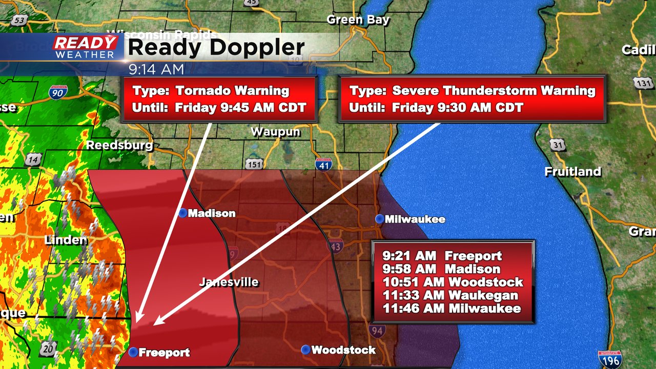
A severe thunderstorm watch has been issued for our southern counties: Walworth, Racine, Kenosha. The watch goes until 1 PM in those areas.
Severe storms are currently on either side of the WI/IL border and moving east at 40 mph. If this line holds together, which it looks like will happen, then strong to severe storms would be around the Madison area at 10 AM and to Milwaukee at 11:30 AM. The storms have a history of 60-80 mph wind gusts in Iowa and a few confirmed tornadoes. Strong winds and a few spin up tornadoes are possible with small hail as the storms roll through.
Another round of storms is still expected during the early evening hours, but depending on how strong this first round of storms is and how the atmosphere can recover, the second round in the evening might not be as strong.
------
Posted: 5:37 a.m. May 24, 2024
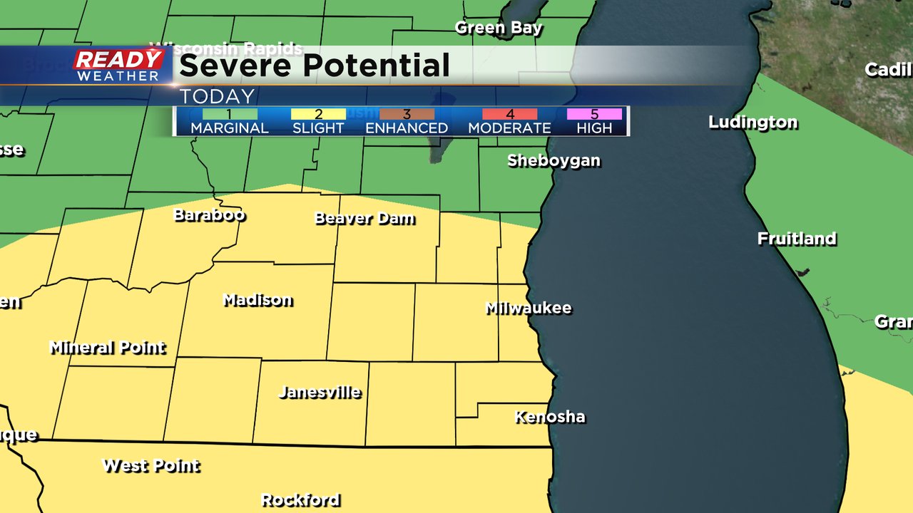
Thursday was a beautiful day around southeast Wisconsin and while Friday morning is starting with a nice sunrise the storm chance will increase later in the day. All of southeast Wisconsin has the threat for strong to severe storms. Most of the local area is under a Level 2 Slight Risk while our northern counties are under a Level 1 Marginal Risk.
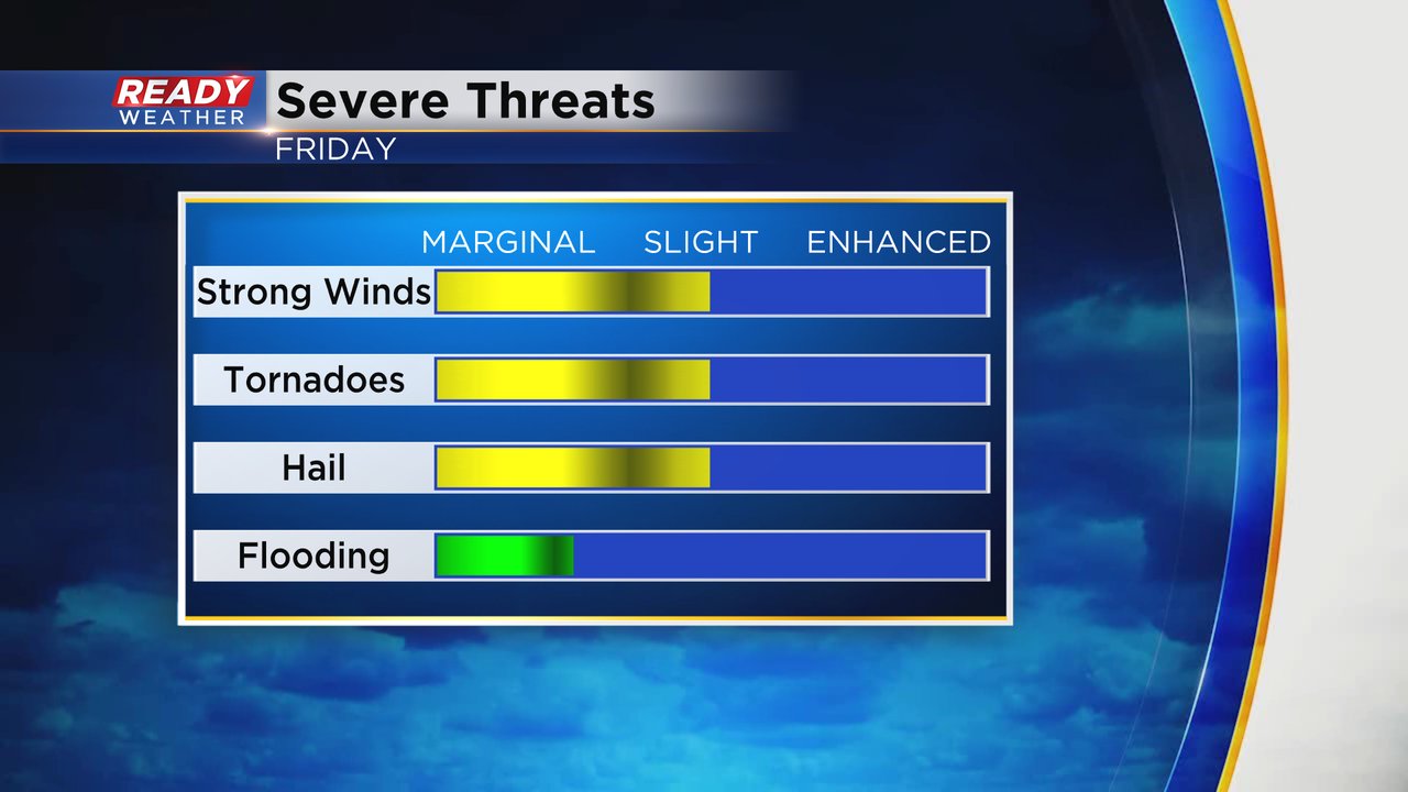
Damaging winds will be our main threat with any severe storms that develop but a few tornadoes are possible and some large hail could fall with any storms that become isolated. Brief street flooding can't be ruled out as the storms roll through.
These storms look to move through southeast Wisconsin in two rounds. The first is what we are seeing in Iowa Friday morning where tornado warnings have been ongoing all night long. That line of storms is projected to arrive locally between 10 AM to 2 PM but it could weaken before it fully moves in. Some isolated strong to severe storms are possible with the first round.

The second round has a bit of a better chance to see strong to severe storms with another line developing to our west and rolling in between 5 PM - 9 PM. Southern counties have the best chance to see stronger storms. Some tornadoes are possible.

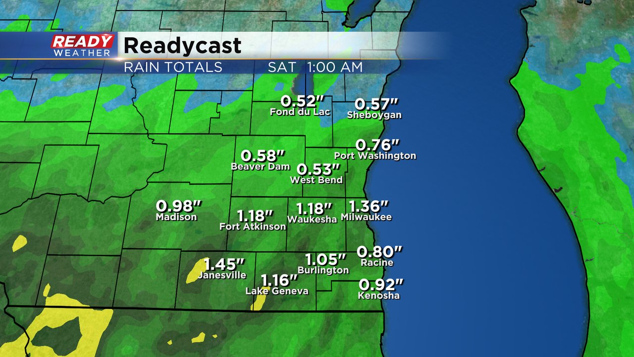
This will be another round of soaking rain for most of the local area with rain totals hovering around 1" for most of southeast Wisconsin but as we've seen with other storm chances this year it is not out of the question for areas that get good strong thunderstorms to see 2" or 3" of rain. Northern counties likely see the least amount with around a half inch of rain.
Download the CBS 58 Ready Weather app to track the storms throughout Friday.