Temp roller coaster: Fall, summer, then fall

-
3:18

St. Francis’ Buddy Squirrel celebrates 110 years of traditions,...
-
2:43

’Movement is medicine:’ Wisconsinites with Parkinson’s...
-
3:56

Milwaukee boy uses art to carry on dad’s legacy, after losing...
-
2:57

A quiet Easter but on/off shower activity much of this week
-
0:56

People gather at the Bear Moon Pow Wow in celebration of culture...
-
1:07

Milwaukee County Zoo hosts pre-Easter celebration filled with...
-
2:30

Kewaskum police chief, lieutenant could face discipline after...
-
2:04

Big races in Wisconsin’s upcoming spring election Tuesday
-
1:10

Schlesinger’s Saturday Showcase (4/4)...Lots of Easter fun...
-
2:57

Easter holiday weekend starts on a wet note but major improvements...
-
1:12

Wisconsin AG Kaul, Gov. Evers join lawsuit challenging Trump...
-
2:44

Bodycam video shows chaos ensue at Bayshore Mall during ‘teen...

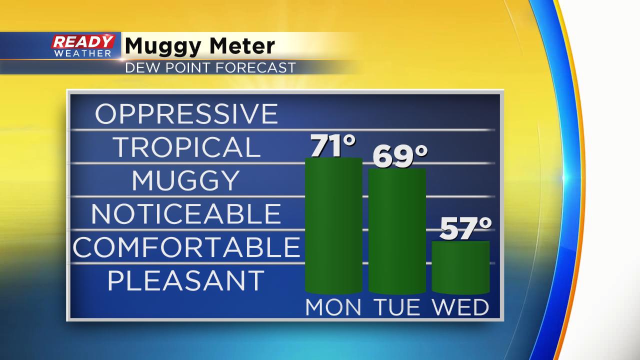
The weekend was very fall-like. Saturday was the coldest since June 2 and Sunday was gloomy all day with rain and mist. Monday - a much different story. Highs will surge about 20° warmer with highs in the low to middle 80s. It's actually not far from record levels. The current record is 88° set back in 1971.

The warmth will last another day into Tuesday where highs hover around 80° before cooling in the afternoon and evening as the cold front moves through. Temperatures will then drop another 20° and hover around 60° Wednesday through Saturday.

Expect lots of humidity with this summer-like warmth. Dew points through Tuesday afternoon hover around 70° making it feel pretty tropical.
Download the CBS 58 Ready Weather App to see if there's any more warmth in the 10-day forecast.