8:30 PM Update: Storms are looking less organized


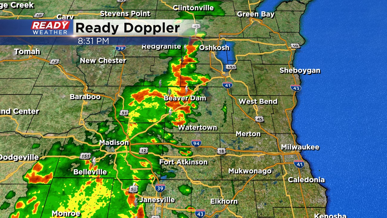
Updated: 8:30 pm May 13th, 2022:
Storms continue to run into each other across the western part of our area tonight. A few warnings occurred earlier this evening. Storms are becoming more and more disorganized. As the sun sets these storms will loose steam.
Locally heavy rainfall remains the main concern for western Fond du Lac, Dodge, and Jefferson counties. Storms will remain across the western counties tonight and won't impact the Deer District.
_____________________________________________________________________________________________________________
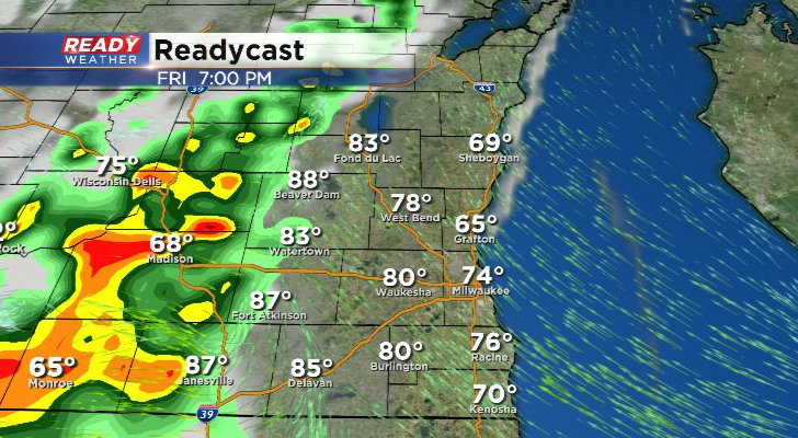
Updated: 7:30 pm May 13th, 2022:
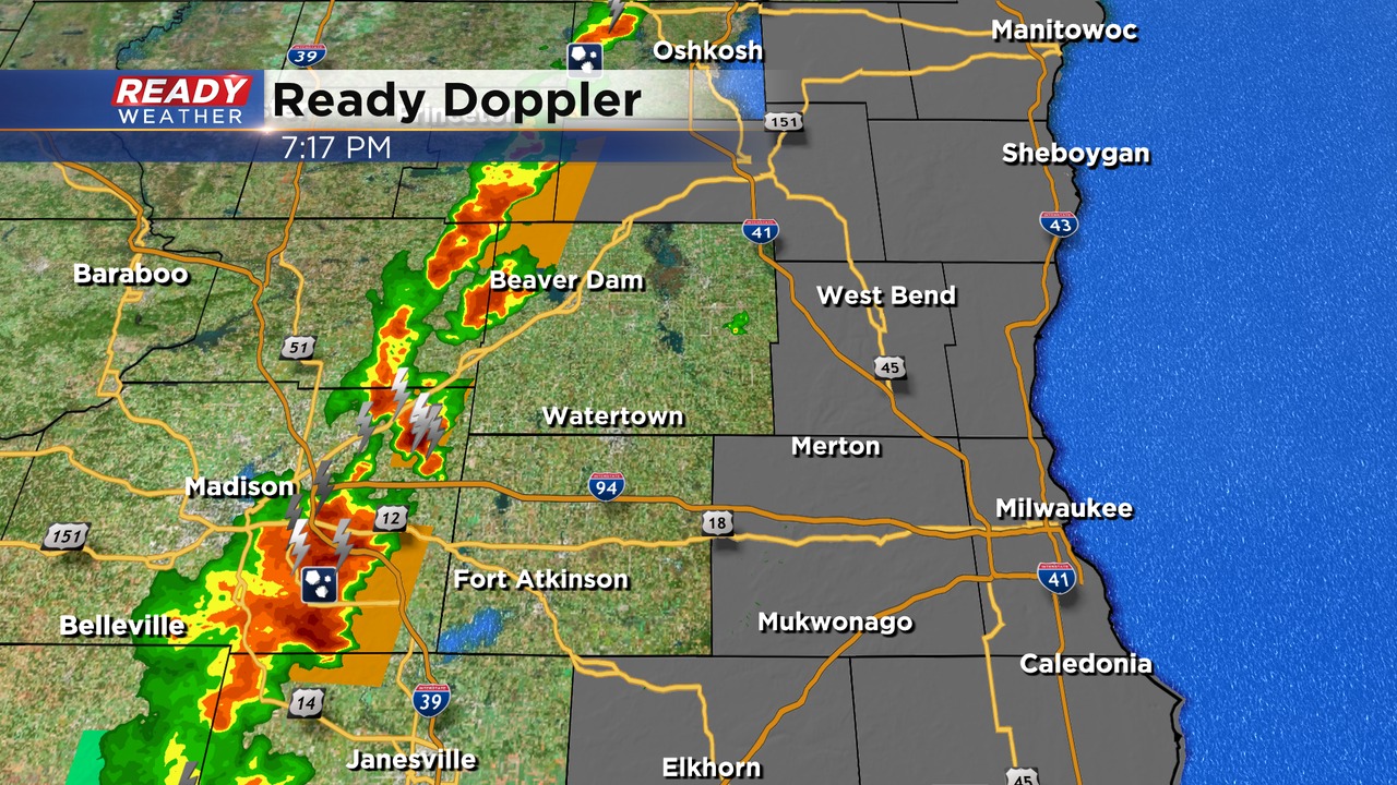
Storms have moved across the western part of our area this evening. A few warnings have been issued for hail. Some additional warnings remain possible; however, all of these storms will stay well west of the lakefront.
The hail chance will persist until 10 pm as the storms slowly weaken. Hail up to quarter size is possible. Lack of deep moisture is limiting the overall severity of storms.
______________________________________________________________________________________________________________
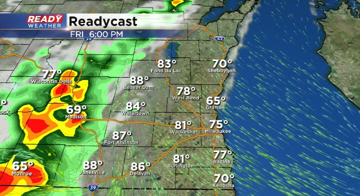
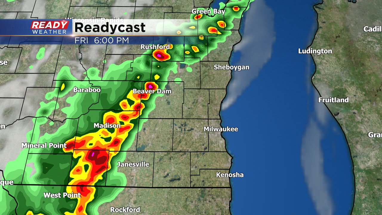
Updated: 6:00 pm May 13th, 2022:
Storms are beginning to fire in northern Illinois and are tracking north-northeast. These storms are expected to continue to build into southern WI over the next few hours.
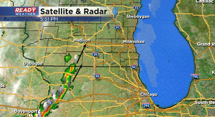
Storms will pose a strong wind and heavy rain threat near Monroe, Janesville, and Madison, and that threat could sneak into western Jefferson, Dodge, Fond du Lac, and Walworth counties before storms weaken around/after sunset at 8:06 pm.
--------------------------------------------------------
Updated: 3:00 pm May 13th, 2022:
The latest update from the Storm Prediction Center has shifted the Slight Risk about 15 miles to the east, but still doesn't cover any part of southeast Wisconsin.
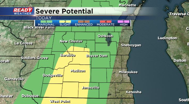
This is due to drier air already filtering into far SW WI where dew points have dropped into the mid 50s. Scattered strong storms will likely develop within the slight risk area between 5-7 pm, weakening as they slowly push east into Fond du Lac, Jefferson, and Dodge counties into the evening.
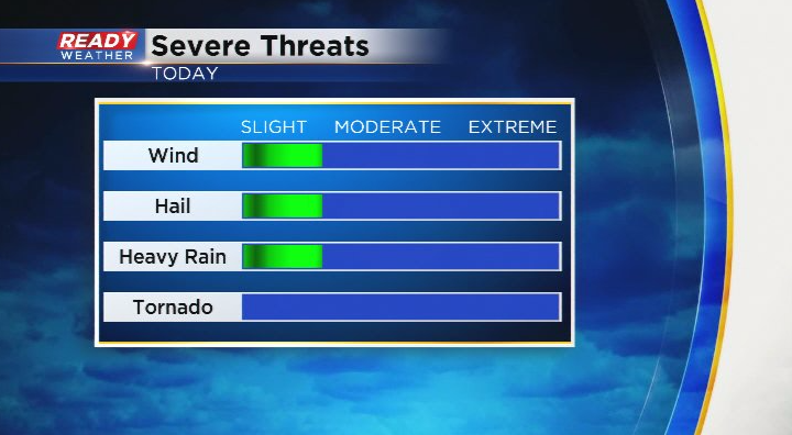
Can't rule out some hail and gusty winds with the storms west of the Metro.
------------------------------------------------------------------------------------------------------
Updated: 12:00 pm May 13th, 2022:
Areas near and west of Madison continue to have the best shot at a few severe storms today, so they've been upgraded to a Level 2, Slight Risk, while the Level 1, Marginal Risk remains unchanged in parts of SE WI.
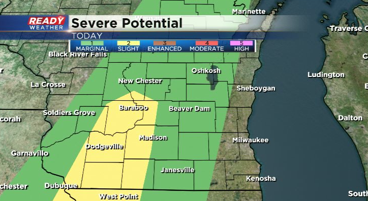
These strong to severe storms look to fire between 4-6pm west of our area, weakening as they slowly push east into the evening.
That being said, we can't rule out a few stronger storms with gusty winds and hail in Fond du Lac, Dodge, Jefferson, or western Walworth counties between 6-9pm.
Storms still look like they'll largely dissipate before reaching Milwaukee/the lakefront.
---------------------------------------------------------------
Updated: 9:03 a.m. May 13, 2022
The Storm Prediction has removed the Level 2 Slight risk from all of Wisconsin. A Level 1 Marginal risk for severe weather is still in place for our western half of counties locally. A few strong storms could still be possible in these communities after 5 PM Friday evening. Storms will likely weaken or completely dissipate before they hit Milwaukee and the lakefront, especially to the south.

------
Posted: 6:22 a.m. May 13, 2022
Happy Friday the 13th and our last really hot day during this warm stretch of May weather. Another hot day with highs in the 80s plus a touch of humidity will add fuel to some thunderstorm chances Friday evening. Storms look to develop pretty quickly around or west of Madison after 5 PM Friday then slowly move east. Many models have the storms weakening pretty quickly. Our western counties in Fond du Lac, Dodge and Jefferson have the best chance to see a stronger thunderstorm.
The rain chance will decrease quickly the farther east you live with very little chance for rain in Milwaukee. There's a small sliver of level 2 slight risk across the country Friday that includes our western counties. A few more of our counties are under the level 1 marginal risk but storm chances really decrease the closer you live to the Lake. Hail and wind will be the main threats although if the storms move slow we could get some heavy rain. The tornado risk is pretty close to 0.

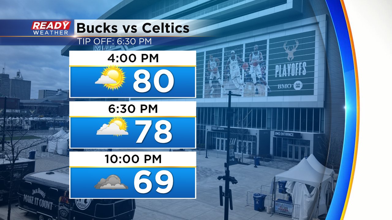
If you are heading out the Deer District for the Bucks Game 6 tonight you should dress cool with temperatures in the upper 70s to around 80 before the game but then cooling into the low 70s by the end of the game. Most of the rain should stay away from downtown Milwaukee but you might want to have a poncho or something with a hood just in case.
Download the CBS 58 Ready Weather app to track the storms.