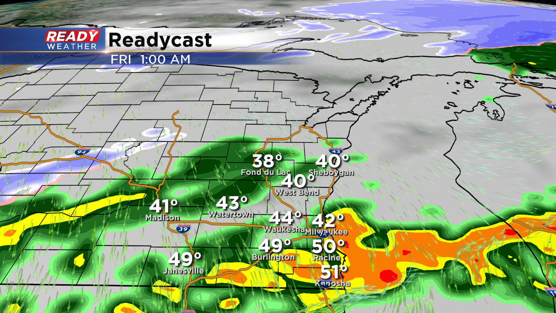
10 PM Update: Severe chances are over. Some additional storms possible.


Good news the front has blown through the area tonight. That has effectively cut off the instability and limit any storms from becoming surface based. Elevated storms remain possible through 2 am, but no more severe weather is expected across southeastern Wisconsin!
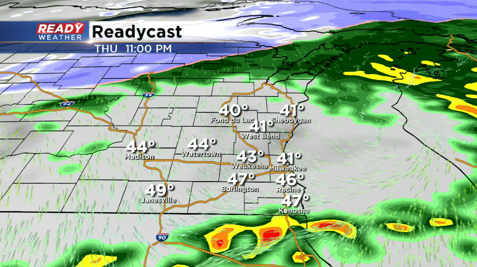
There's still a chance for some snow showers overnight into Friday morning with temperatures falling into the 30s.
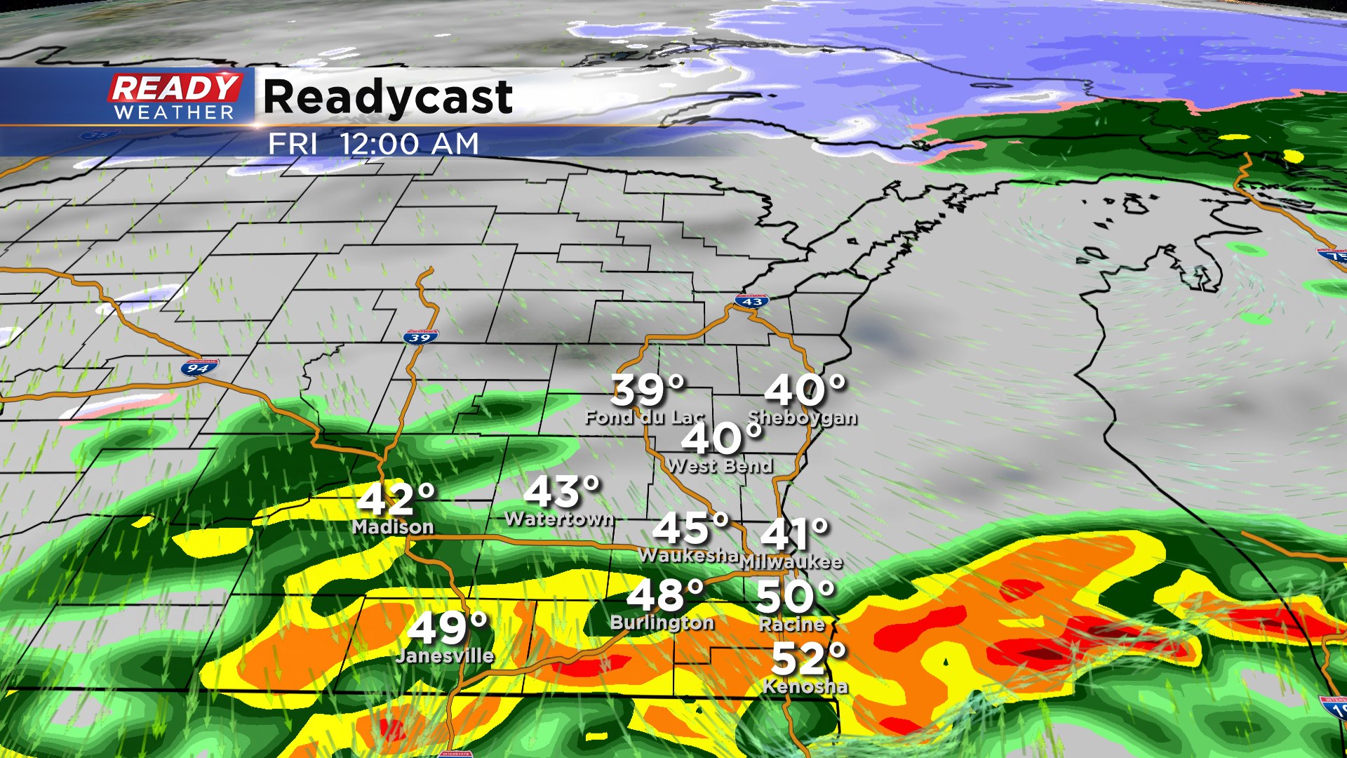
8 PM Update:
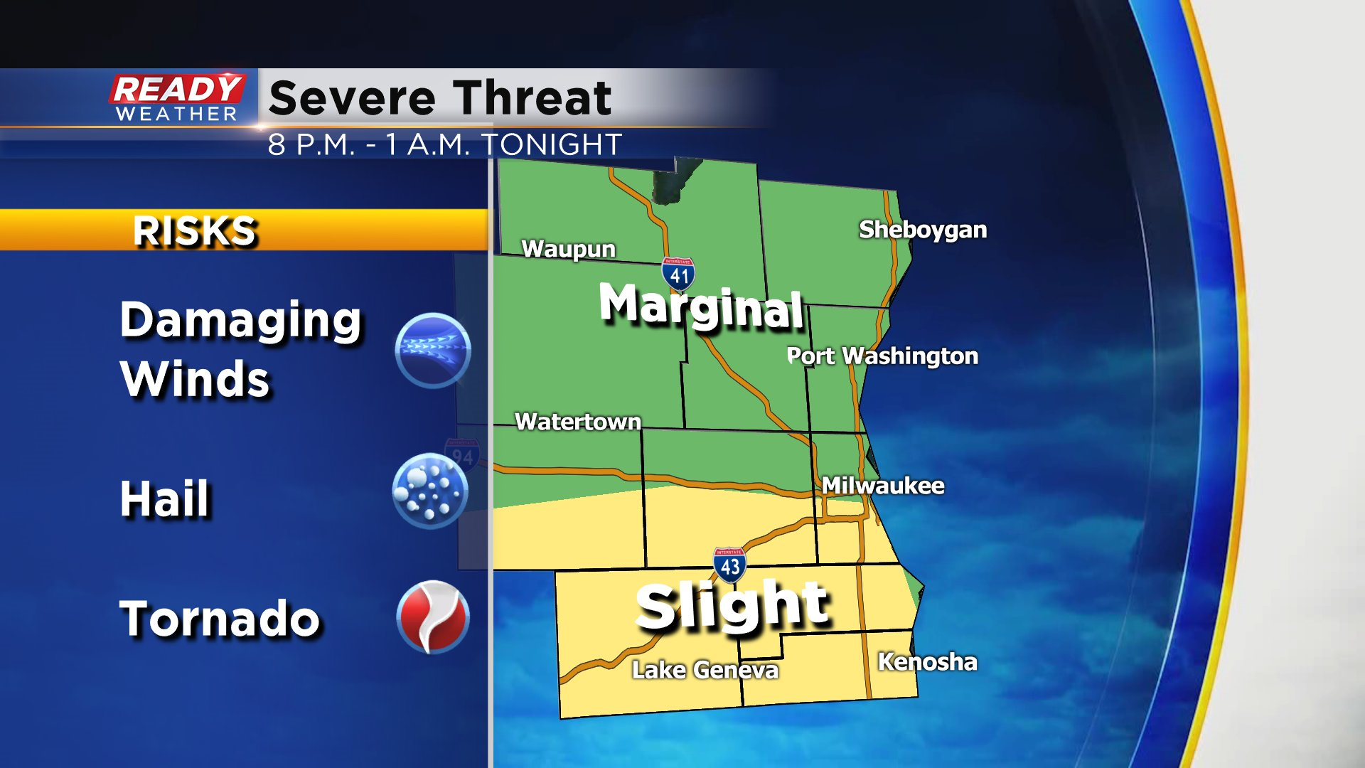
The edge of the warm air or the warm front might move across our southern counties late this evening. That might allow enough instability for a few showers and storms to turn strong to severe along the border. As you can see by this graphic by midnight there could be storms from Walworth to Kenosha counties.
The window is very small, so this is going to be completely isolated. Milwaukee and Waukesha will be north and won't be impacted.
______________________________________________________________________________________________________________
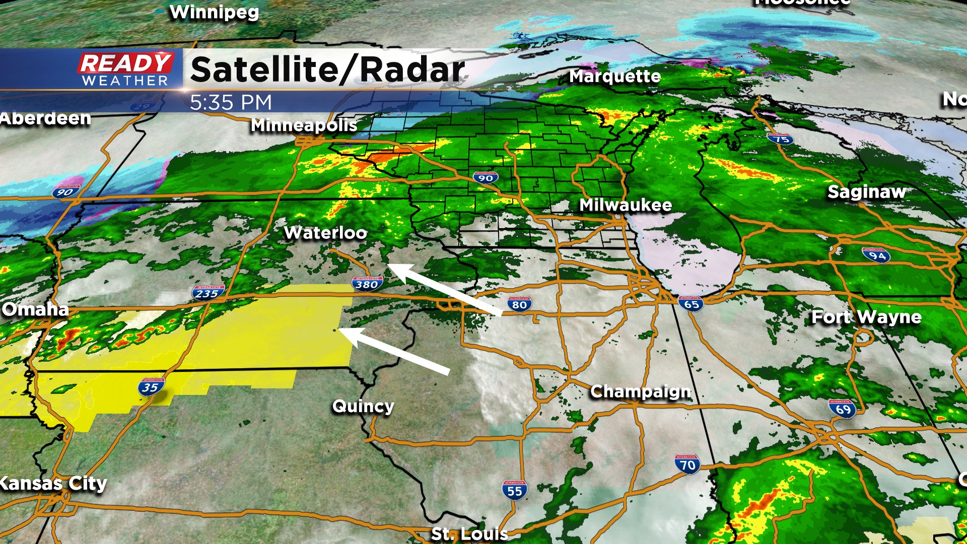
6 PM Update:
No changes with the going forecast. The slight risk remains in the same spot for now. Take a look at the graphic above. We are watching a lot of Iowa at this point for more storm redevelopment. They have cleared out and storms should be firing over the next couple of hours.
Those storms will move northeast along the warm front and try to nudge across southeastern Wisconsin between 9 pm and 1 am. If storms can move into our area they have a chance to become strong to severe. There remains a chance for damaging winds or a very isolated tornado across Walworth, Racine, and Kenosha counties.
______________________________________________________________________________________________________________
4 PM Update:
This current batch of light to moderate rain will push northeast overnight. By 7 pm most of it will be gone as we wait for the second shot of showers and storms. The severe weather risk for this evening remains along and south of the WI/IL border where the best instability will sit.
Storms will once again make a run at us between 9 pm and 1 am. Storms that hug the border across Walworth and Kenosha counties could contain strong winds and a very isolated tornado.
______________________________________________________________________________________________________________
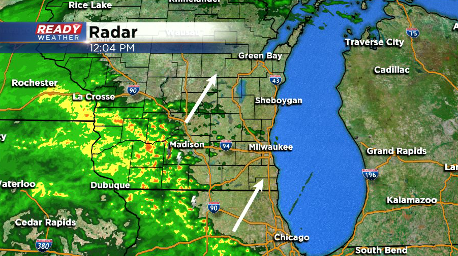
Take a look at the rain that is blanketing most of Wisconsin. All of this moisture is ahead of the warm front that will nose into our area lter this evening. Rain and some rumbles of thunder are likely through the rest of the afternoon into the early evening.
More storms are expected to develop this evening across Iowa and will race east. The actual warm front may stay just along the border of IL/WI. This afternoon's rain will likely reinforce the boundary further south.
The best chance for a strong to severe storm will be along the border of IL/WI.
Later tonight the rain will turn over to snow showers for the Friday morning commute.
Updated: 12:10 p.m. March 19, 2020
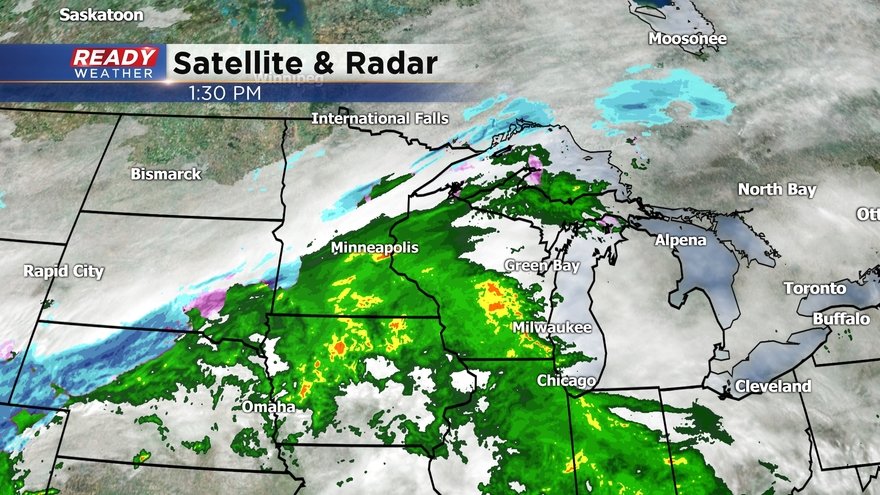
Rain and isolated storms continue to close in on southeast Wisconsin and should overspread the area between 1-2 p.m.
The Storm Prediction Center has cut back on the Slight Risk (level 2 of 5) for severe storms. The Slight Risk now covers locations along and south of I-94.
At this point, the warm front looks like it'll stay just south of Wisconsin, which means the best chance for any strong to severe storms will likely be along the Wisconsin/Illinois border. However, any thunderstorm with moderate rain could easily produce wind gusts over 50 mph this evening. Best chance at any isolated severe storms will be after 9 p.m.
-----------------------------------------------------------------------------------------
Updated: 10:05 a.m. March 19, 2020
Scattered showers and storms are approaching from the southwest and still on track to arrive this afternoon. The best chance for severe weather will be near the Illinois border after 7 p.m. this evening. Damaging wind is the main threat however a brief tornado cannot be ruled out.

------
Posted: 6:32 a.m. March 19, 2020
After a dry start on Thursday the chance for showers and storms will start to increase during the afternoon and evening. A warm front to our south with plenty of rain that's already produced tornadoes in Texas will combine with a cold front to our northwest colliding over the Upper Midwest giving us a chance for severe weather.

A soaking rain will be possible for most locations with a half to full inch of rain possible. Rivers will likely swell but widespread flooding is not expected.

The best chance for severe weather is in our southern counties near the Wisconsin/Illinois border. Temperatures for most of Thursday will stay in the low to middle 40s but as the warm front arrives we will briefly spike to the middle and upper 50s. Southern communities will get the warmest giving them the most energy for stronger storms. Areas along and south of I-94 are in the slight risk for severe weather and counties north of there are in the marginal risk for severe weather.

Damaging wind will likely be the main threat with any severe storms that do develop. Some hail, heavy downpours and brief tornadoes will be possible too. The best timing for any severe storms will be from 7 p.m. and midnight meaning if tornadoes happen it could be after dark and some could be sleeping. Make sure you have multiple ways to get warnings.

A weather radio is a good thing to have and make sure the volume is up on your phones to get alerts from the CBS 58 Ready Weather App.