UPDATE: Wintry mix with accumulating snow possible Saturday night
Updated: 9:36 a.m. November 11, 2017
UPDATE: A little light snow is currently moving through some of our northern counties. Parts of Fond du Lac and Sheboygan Counties may see a dusting of snow to a few tenths of an inch through noon on Saturday. Extreme northern parts of Dodge, Washington and Ozaukee Counties may also see some snow, but snow south of there is not expected for Saturday.
Although a few flurries and some drizzle can't be ruled out Saturday afternoon, the majority of the area stays dry until Saturday night.
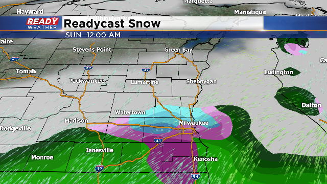
Around 7:00 p.m. another wave of wintery-like precipitation is possible. Everyone looks to see at leas some type of a rain/snow mix when it starts falling, but areas along and south of I-94 will likely see the most measureable accumulation.
Weather models are just starting to come together on this storm system which has the potential to drop a couple inches of snow. Temperatures will be very important since they will hover right around freezing for most of Sunday morning before warming. The best chance for accumulating snow looks to be between midnight and 9 a.m. Sunday morning. A touch of freezing drizzle could also be possible but the main precipitation type Sunday morning will be light snow before transitioning back over to a rain/snow mix.
------
Posted: 10:10 p.m. November 10, 2017
More winter weather will arrive for Saturday. A system to our west will provide snow showers for the northern part of our area by Saturday morning. The best chance for accumulating snow will stay across central and northern Wisconsin.
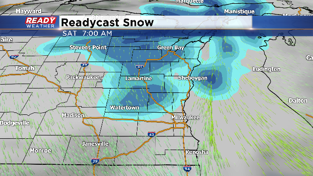
While most of the snow accumulation will occur throughout the northwoods, some accumulation is possible for Sheboygan, Fond du Lac, Washington, Dodge, and Ozaukee counties between 4 am and 9 am. Accumulation for Saturday morning should be an inch or less.
The snow clears out for those areas by the late morning, with another chance for a mix for Saturday evening. When we say mix, we are talking about some rain, sleet, and possibly some freezing rain. Depending upon surface temperatures, some light icing could occur for Saturday evening.
Use caution if you come across areas of freezing rain or drizzle. Elevated surfaces like bridges and overpasses could have some icing.
The precipitation should come to an end overnight going into Sunday morning.
