Overnight Update: High wind warning expires, wind chill advisory up next


Updated: 10:22 p.m. February 24, 2019
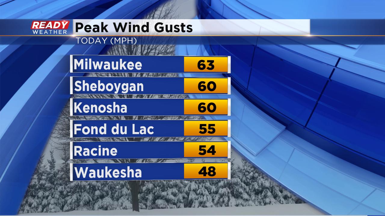
Here are the final peak wind gusts from Sunday. Milwaukee topped the list at 63 mph.
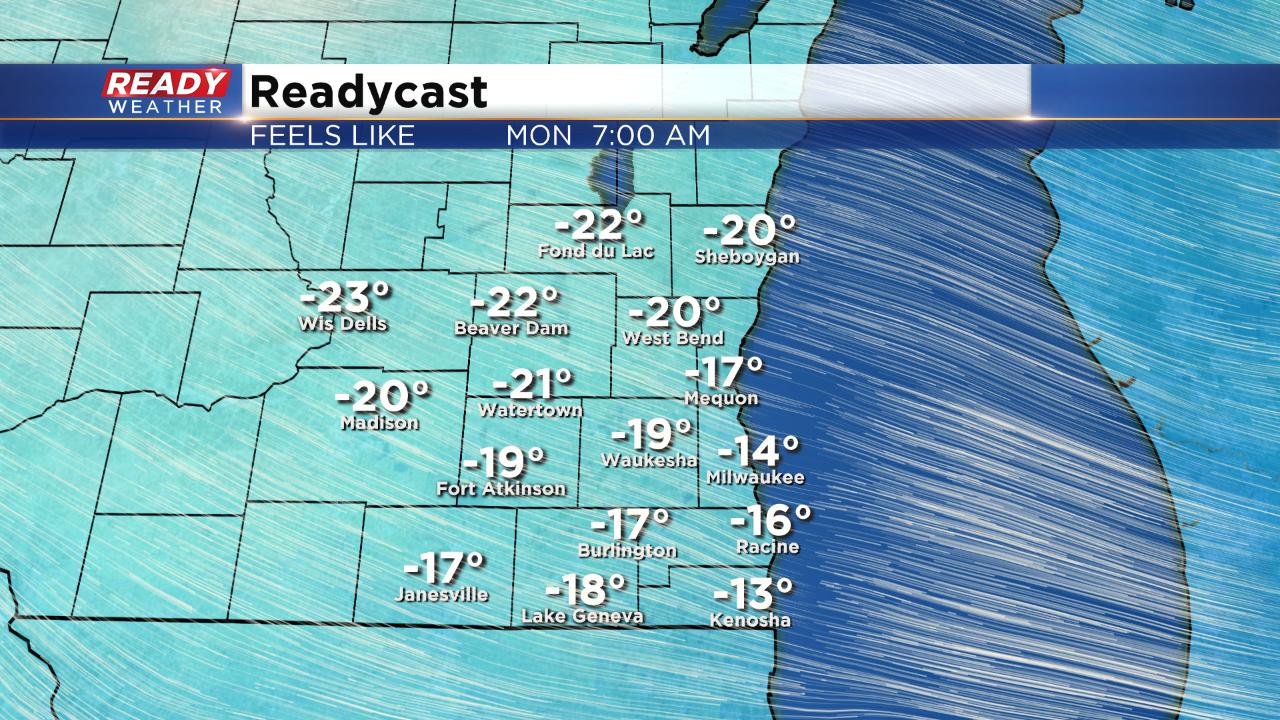
Wind chill values are still on track Monday morning to reach -25° in some spots and stay at or below-zero all day.
------
Updated: 9:10 p.m. February 24, 2019
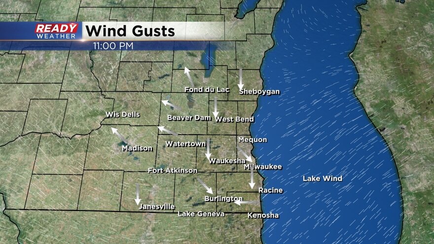
The high wind warning has officially expired as of 9 p.m. Wind gusts are still very high and will slowly go down overnight. Here are the current wind gusts that will update in real time.
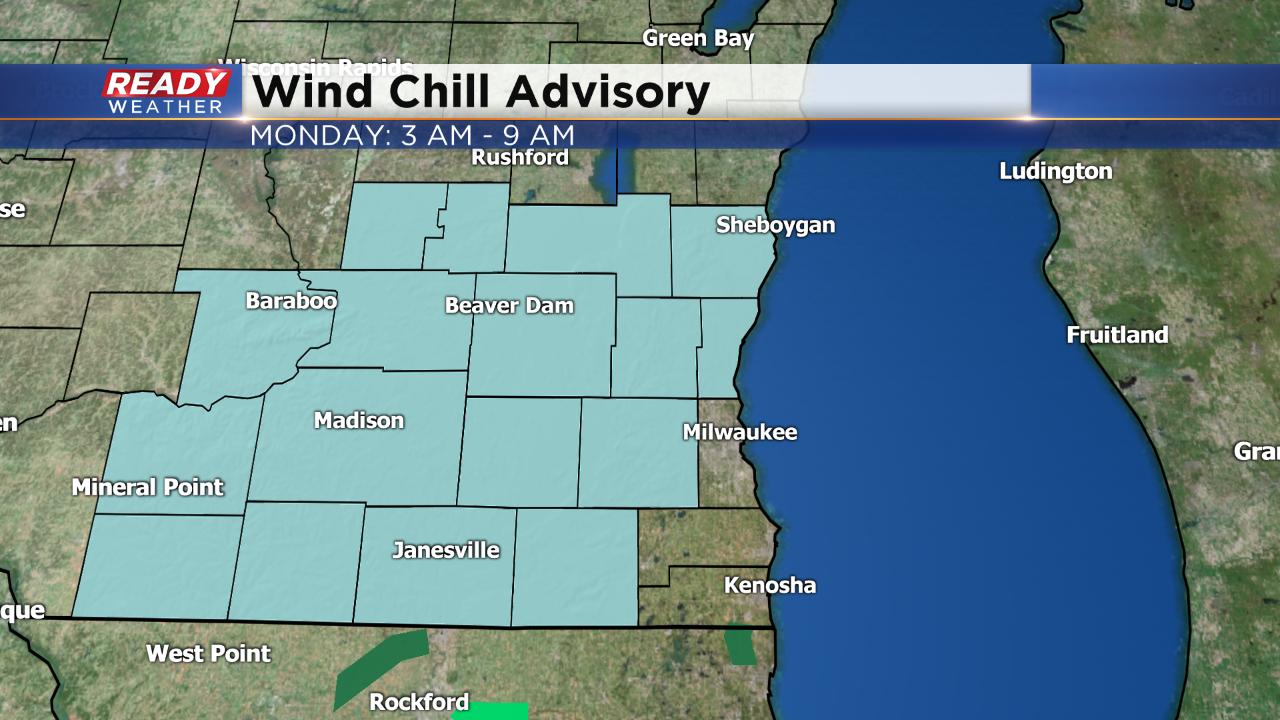
Next up is the wind chill advisory that starts at 3 a.m. Monday morning. Wind chills as of 9 p.m. are already sub-zero.
------
Updated: 6:16 p.m. February 24, 2019
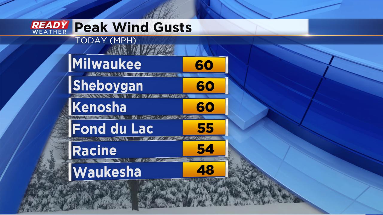
Wind gusts are starting to slowly come down and will continue to do so the rest of the night. The High Wind Warning is still expected to expire at 9 p.m. Milwaukee has joined the list of cities seeing peak wind gusts hit 60 mph.
Although the wind will die down expect gusts to 30 mph Sunday night leading to cold wind chills. By Monday morning most of southeast will see feel like temperatures between -15 to -25. Wind chills don't get much better and hover around 0° Monday afternoon.
------
Updated: 4:01 p.m. February 24, 2019
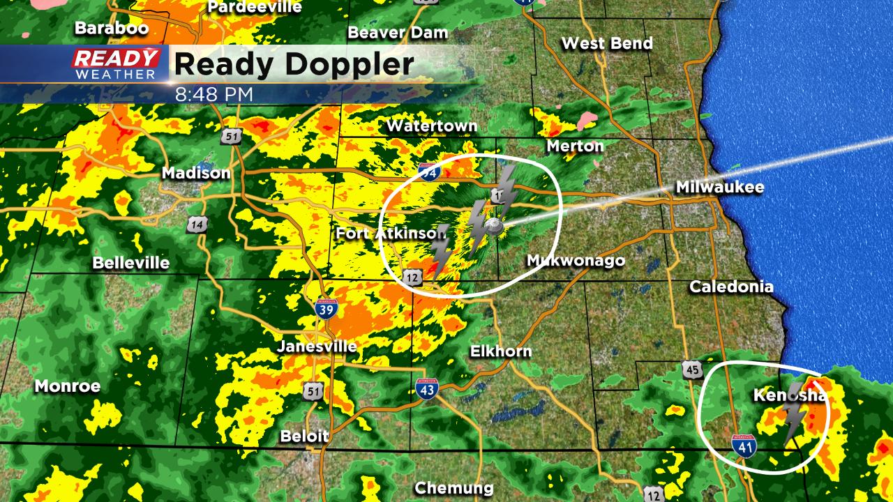
The dangerously strong wind continues with afternoon gusts still hitting 60 mph. Lakeside areas have seen the most wind with Kenosha, Sheboygan and Milwaukee all seeing peak gusts so far of 60 mph. Everyone in southeast Wisconsin has experienced gusts of at least 45 mph.

The wind will slowly die down after 9 p.m. Sunday night but stay windy overnight with gusts to 30 mph. Wind gusts on Monday could hit 20 mph at times. Air temperatures will hit the single digits to around 0° Monday morning forcing wind chills as cold as -25°. A wind chill advisory has been issued for most of southeast Wisconsin excluding Milwaukee, Racine and Kenosha Counties. The advisory runs from 3 a.m. Monday until 9 a.m.
------
Updated 1:15 p.m. February 24, 2019
This morning's snowfall is done with most see a dusting, if that. The wind has stayed strong and peak wind gusts so far have ranged anywhere between 40-60 mph. See this tweet from the National Weather Service with some peak wind gusts.
It is really windy out there! North-south roads are especially hazardous to high-profile vehicles today. Blowing snow may cause slick spots on roads. Tree and minor structural damage is possible, with scattered power outages. #swiwxpic.twitter.com/Wwo8LQptX5
— NWS Milwaukee (@NWSMKX) February 24, 2019
Here are the current wind gusts that update in real time.
The wind will stay strong through evening and then slowly come down starting at 9 p.m. when the High Wind Warning expires. Wind will stay breezy for Monday with wind chills Monday morning as low as -20.
------
Updated: 7:25 a.m. February 24, 2019
The heavy rain from overnight is done and the lingering rain has switched to light snow expect snow to continue through around noon with less than 1” for most of southeast Wisconsin.
Wind is the big story today. A wind gust of 58 mph has already been recorded in Kenosha Sunday morning
———
Updated: 10:41 p.m. February 23, 2019
Steady moderate to heavy rain is still falling across most of southeast Wisconsin. Expect the rain to stay heavy before becoming more scattered overnight and eventually switching to snow by early Sunday.
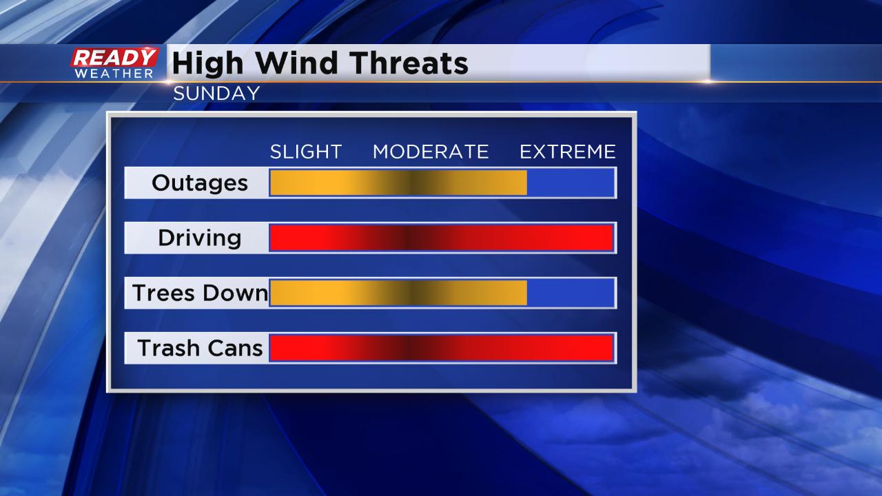
Wind will be the big story Sunday with wind gusts to 60 mph possible. Driving will be difficult and power outages are expected. if you don't put your trash can in the garage you'll likely find it down the street.
------
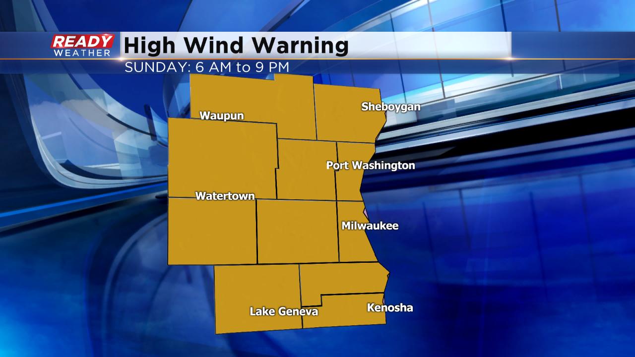
Updated: 8:29 p.m. February 23, 2019
All of southeast Wisconsin just got upgraded to a rare high wind warning. Wind gusts could reach 60 mph Sunday. The advisory is in effect from 6 a.m. until 9 p.m. High profile vehicles like trucks should avoid driving. Driving on north, south highways will be white knuckled. Widespread power outages are possible.
In addition to the high wind warning, lightning has been detected with a thunderstorm moving through Rock and Walworth Counties. Some small hail may be possible.
------
Posted: 5:55 p.m. February 23, 2019
It's already been a busy day of weather and it's about to get even busier. Most of southeast Wisconsin woke up to rapidly changing weather with drizzle and freezing drizzle switching to sleet then switching to snow and then finally rain to round out the morning. A few spots saw a tenth of ice, but road conditions stayed in fairly good shape. Some areas have already picked up a half inch of rainfall since Saturday night.
After a lull Saturday afternoon, another round rain moves in Saturday evening between 6-8 p.m. Heavy rain with the possibility of an isolated thunderstorm is likely through midnight before becoming lighter. A flood advisory has been issued for all of southeast Wisconsin due to the possibility of localized flooding. Ice jams could also be an issue.
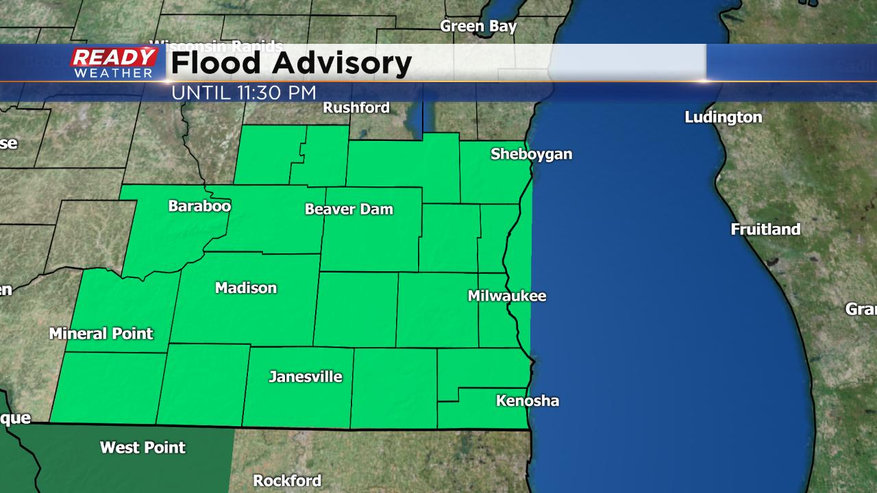
An additional half inch to full of rain will be possible by Sunday morning.

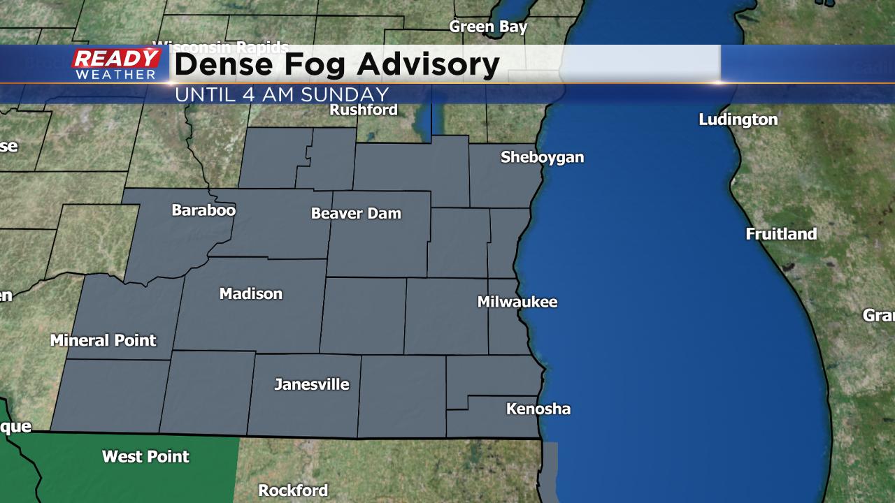
The added moisture in the atmosphere will also allow dense fog to settle in. A dense fog advisory has been issued for all of southeast Wisconsin until 4 a.m. Sunday.
As temperatures cool overnight light rain switches to light snow Sunday morning. Snow accumulation is not expected to be great with most of us only seeing a tenth or two but some northern areas around Fond du Lac, Sheboygan, Beaver Dam and West Bend could see around 1" of heavy, wet snow.

The northern part of the state misses out on the rain seeing just snow. Near-blizzard conditions are expected across northern Wisconsin where spots could pick up another foot of snow.
Wind will be the bigger story on Sunday. A wind advisory has been issued for all of southeast Wisconsin from 6 a.m. Sunday until midnight. The National Weather Service has also discussed the possibility of adding some of our southern counties to a High Wind Warning.
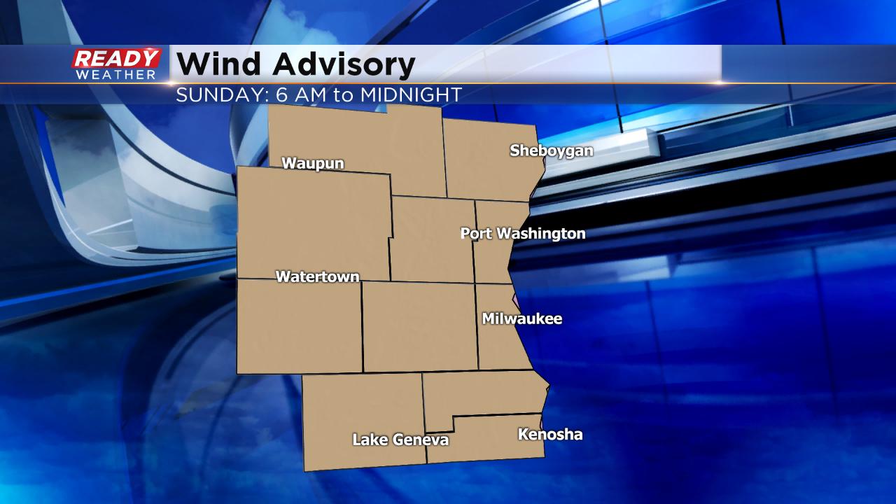
Wind gusts will be the worst from mid-morning through Sunday evening when gusts will stay between 40-50 mph. The strong wind combined with a soggy ground could cause some trees to come down and widespread power outages are possible. The wind will be out of the west so use caution when driving on north-south highways. High profile trucks should avoid travel.

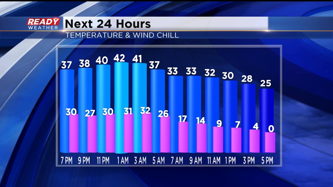
The wind will also cause a big drop in temperatures. Sunday will be a bit of a backwards day with the "high" temperature actually happening around midnight Sunday morning near 40°. Wake up temps will be around 32° then cooling into the 20s for the afternoon. Because of the wind, wind chills will be a big factor feeling more like the single digits and teens during the afternoon and then going subzero at night. By Monday morning expect air temps in the single digits with wind chills as cold as -20°.
The weather continues to stay active this upcoming week with multiple chances for light snow and temperatures staying below-average. Download the CBS 58 Ready Weather app to stay on top of it all.