Mid-evening update: Storms ending into the overnight


9:00 PM Update:
Strong to severe storms are moving through the area right now. A Severe Thunderstorm Warning remains in effect until 9:30 p.m. for the metro area. Heavy rains, frequent lightning, and hail are all possible. Please don't drive on water-covered roads.Most storms should be out of here by midnight.
Last Warning of the evening...


6:30 PM Update:
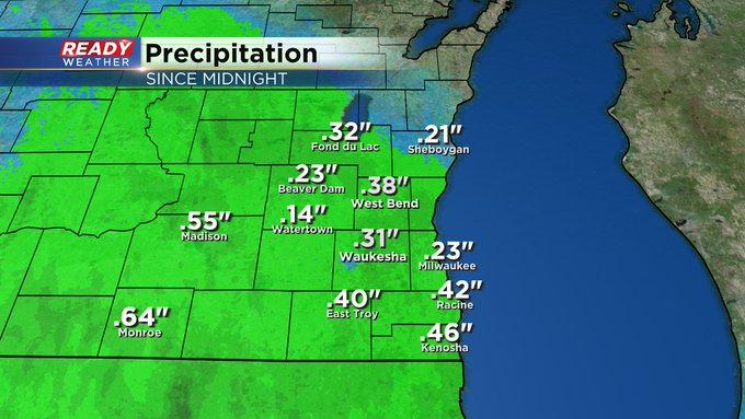
Here's a look at the rainfall totals from earlier today! The normal for May is 3.54"!


______________________________________________________________________________________________________________
5:30 PM Update:
There's a break in the action this early evening. The third round of showers and storms are expected between 7 pm and 10 pm. While some storms may contain small hail and gusty winds, the overall severe weather risk is low.

These scattered storms will be out after midnight with quiet weather expected for Wednesday.
_____________________________________________________________________________________________________________
4:30 pm Update:

Thankfully, the severe storms have moved out over the lake. Some storms have produced 60 mph winds and some quarter to half dollar hail. The tornado watch has been canceled.
Additional scattered rain and some storms are possible during the evening; however, the overall severe risk is low. The greatest severe threat has passed.
_____________________________________________________________________________________________________________
3:00 pm Update:

Strong to severe storms capable of producing quarter hail and damaging winds are moving across the area. Power outages and damage have been reported in Walworth county.
Storms this afternoon have had the history of some rotation. We expect the severe threat to weaken after 6 pm.
_____________________________________________________________________________________________________________
1:25 PM Update:
Scattered showers and storms are pulsing up this afternoon. Currently one cell is under a Severe Thunderstorm Warning in northern IL and will push into Walworth county just after 2pm. Gusty wind and hail are main threats here, meanwhile more tornadic weather could unfold just to our south in Illinois. The forecast remains on track but will continue to update conditions as warranted.

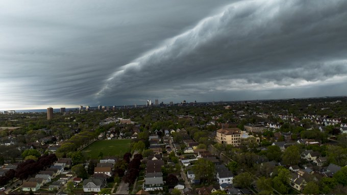
11 AM Update:
The first line has pushed through the area. Lots of neat leading edge cloud shots coming at us. Here's one from Bert Lauderdale this morning.
Updated: 9:31 a.m. May 7, 2024
The first round of storms is here and rolling through southeast Wisconsin. The storms have behaved and are not strong or severe however they are bringing lots of lightning, thunder and torrential downpours. This first round of rain will last about two hours in any given location with Sheboygan the last one to see the rain and have it leave as the NW to SE oriented line rolls through.
Here's a radar image that will update with time today:

Behind the first round of rain, clouds are starting to clear in Iowa. If we can get that clearing locally, our chances for strong to severe storms this afternoon could increase. The bes timing for those stronger thunderstorms looks like 2-6 PM. There are no changes with the severe risks for today with gusty wind and small hail the biggest threats and a very low tornado risk.
------
Posted: 5:19 a.m. May 7, 2024
A few rounds of storms are possible on Tuesday. Some of the rounds look more likely than others but strong storms are possible in each round. The first round is a line of storms rolling in from Minnesota and Iowa. Some of those storms are still severe in Iowa and areas south of there and once the sun comes up some of those storms could perk up.
Here's a radar image that will update with time today:

As the first round of rain exits, we may get an hour or two of dry time with some sunshine around noon. Depending on how much sunshine we see will determine if the second round of storms will also be strong in the afternoon. The more sunshine, the better chance for an isolated severe storm. A few showers or rumbles of thunder could linger into the evening hours but likely stays sub-severe.

There's no change to the severe risk for southeast Wisconsin today from what we showed you Monday. All of southeast Wisconsin is in the Level 1 Marginal Risk with better chances for severe weather to our southeast in Indiana, Ohio and Kentucky.
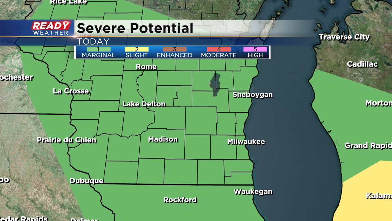
Any storms that do become strong will bring mainly a gusty wind and small hail threat. The tornado threat is virtually zero and there's no flooding risk.

Download the CBS 58 Ready Weather app to track the storms with the interactive radar.