Accumulating snow is coming for tonight followed by extreme cold


6:45pm Update
The snow is still on track for tonight with the amounts shown below. I also want to drop in the wind chills expected for the timeframe of early Friday through much of Saturday with extreme cold expected. Highs are likely only near zero with lows -5 to -15 degrees and chills during the afternoon around -25 but night time chills to around sunrise will be in the order of -30 to -40. Use extreme caution for air this frigid!!

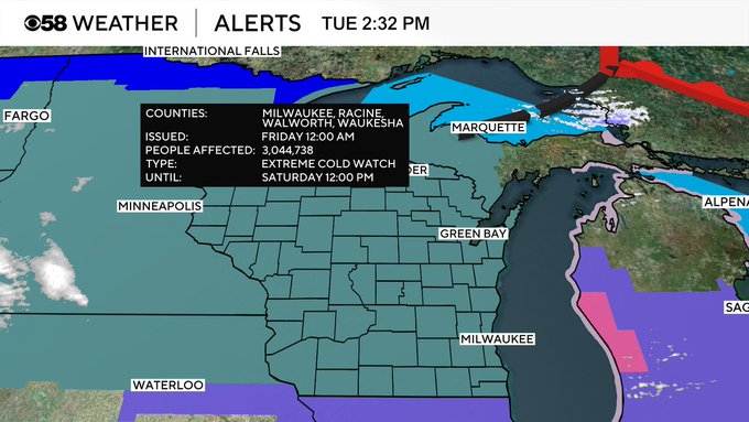
2:30pm Update:
The National Weather Service has issued a relatively rare Extreme Cold Watch. This includes the entire state of Wisconsin:

The rest of the afternoon and early evening is expected to be cold and dry. Snow showers will arrive after 9 pm and increase from Midnight to 4 am. During that period most of the accumulation will fall.
Within the advisory 3" to 4" is possible. There could be slightly higher totals, especially along the border of IL/WI.

The problem will be temperatures in the teens. Even pretreated roads will become slick and hazardous for the Wednesday morning commute.
______________________________________________________________________________________________________________
The cold air has been the big weather story to start the new week heading into Martin Luther King Jr. Day. Wind chills Monday morning dropped between -30 to -20 for most of southeast Wisconsin with lows in the single digits below-zero and wind gusts to 40 mph.

Wind chills Tuesday morning were about ten degrees warmer in most areas thanks to a lighter wind from 5-15 mph but similar air temperatures in the single digits below-zero. Wind chills will finally go above-zero by Tuesday afternoon and stay above-zero all of Wednesday. Another round of cold air will start to filter in for Thursday.

The brief warm up with wind chills is due to a low pressure system arriving bringing with it the chance for accumulating snow. A winter weather advisory has been issued for our southern half of counties from late Tuesday evening through Wednesday morning. This highlights the counties expected to see the heaviest snow totals but if that axis if heavy snow shifts north then more counties could be added.

Snow chances start by 7 PM on Tuesday with better chances for steady light to moderate snow most of the overnight hours. Snow will come to an end during the morning commute with most areas dry by 9 AM Wednesday. This will be a fairly light and fluffy snow that could blow around with a bit of a breeze on Wednesday. The Wednesday morning commute will likely be snow covered and slick.

Snow totals from Tuesday evening through Wednesday morning will be in the 1-3" range for most of southeast Wisconsin with highest totals in our southern counties.

A second round of snow is possible Wednesday evening for a few hours. This could feature some heavy areas of snow potentially lasting a couple hours in spots. Another inch or two of snow will be possible with the second round. That second round could push snow totals in some areas from Tuesday evening up to 5" with northern counties staying closer to the 1-2" range.

Download the CBS 58 Weather app to track the snow and the dangerous cold that follows for the upcoming weekend.