


Updated: 6:24 a.m. June 18, 2021
The thunderstorm and rain chance is over for Friday morning and the rest of the day looks dry. We didn't see any severe weather in southeast Wisconsin but a few stronger storms dropped a little hail and wind gusts to 50 mph.
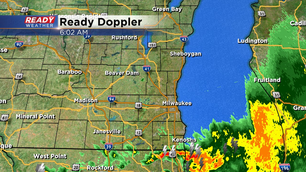
Rain totals are starting to roll in with most of southeast Wisconsin showing 0.50-1" of rain since Thursday night. More rain totals will continue to come in as people wake up and check their rain gauges. A few reports around 1.50 to 2" are definitely possible.

------
Updated: 4:03 a.m. June 18, 2021
The severe thunderstorm watch has been allowed to expire across Wisconsin. We've had a few stronger thunderstorms with small hail and wind gusts to 50 mph but no severe storms have been reported. As of 4 a.m. the rain has ended for our northern counties but some good thunderstorms with heavy rain, lightning and gusty wind are still ongoing south of I94.

We still have a few more hours of this to go with most areas drying out by 8 AM. Rain totals are looking around 1" but some areas may have picked up closer to 2" or 3" of rain. We will know more once reports start coming in. The chance for a few stray showers Friday afternoon has decreased as another cold front won't move across southeast Wisconsin until Friday night. A few storms are now possible Saturday morning but no severe weather is expected.
------
Updated: 1:05 am June 18, 2021
So far, storms continue to behave in our area. this previously warned on storm has weakened below severe limits, but will still comes with heavy rain, wind gusts possibly to 40mph and pea size hail. It's heading into our northern counties travelling east/southeast at 45mph. As of now there are no severe thunderstorm warnings in progress except out over the open waters closer to the bay of Green Bay.
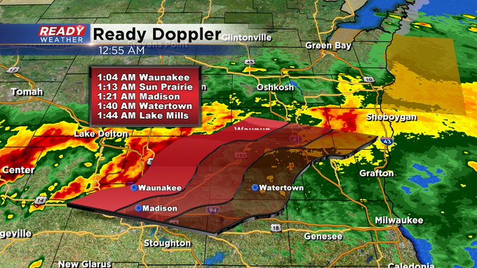
That said, storms have still had winds gusting to 50 mph along with downpours and frequent lightning. Some areas have already received over two inches of rain west of our viewing area. The potential for a solid half to full inch of rain will be possible in spots here that get a few rounds of storms. Rain and storms may not push east and over the lake until 6am. We'll continue to monitor the radar and keep in mind the watch continues until 4am.

Updated: 10:05 pm June 17, 2021:
A Severe Thunderstorm Watch has been issued for all of southeast Wisconsin through 4 am.

Severe cells are beginning to congeal into a line north of La Crosse which will drop southeast into our area between 12a-4a. Damaging winds will be the main threat overnight.

-------------------------------------------------------------------------
Updated: 9:00 pm June 17, 2021:
Most of southeast Wisconsin is seeing a break in the rain right now, but a line of severe storms is getting it's act together to our northwest.

These will continue to train across central Wisconsin for another couple of hours before congealing into a line and dropping southeast. This likely won't reach southeast Wisconsin until around and after midnight. Damaging winds will be possible in this line of storms, so have a way to receive warnings overnight.

-----------------------------------------------------------------------------------------------
Updated: 7:00 pm June 17th, 2021:
Showers and a few isolated storms continue to push through southeast Wisconsin, but they are losing their strength as they run into our drier dew points.

Back to the northwest, severe storms are firing from Eau Claire to the Twin Cities, back into southeast Minnesota. This is the main show we'll be keeping an eye on for the rest of the evening.

We're expecting this to congeal into a line that eventually will push southeast into the area overnight. Damaging winds continue to be the primary threat.
-----------------------------------------------------------------------------
Updated: 5:15 pm June 17th, 2021:
Initial scattered storms have remained below severe limits so far, and these cells will likely continue to weaken as they move into southeast Wisconsin this evening due to the lower dew points we currently have in place.

While some of this rain moves through southeast Wisconsin over the next 1-3 hours, we're still keeping our eye on southeast Minnesota and northeast Iowa for additional thunderstorm development. This is where the cold front is located, and this is the round that would pack the damaging straight-line wind threat. Still expecting the main show to move through between 11pm-4am.

------------------------------------------------------------------------------
Updated 3:00 pm June 17th, 2021:
All is quiet across southeast Wisconsin after a few isolated storms earlier this morning. We're keeping an eye on the storms currently developing near La Crosse and in northern Iowa.

These are forming a bit earlier and slightly farther south than earlier models indicated. Thinking that most of these storms won't make it into southeast Wisconsin until after dark, but this initial activity may sneak into Fond du Lac and Sheboygan counties as early as 7-8 pm.

The main line of storms is still expected to push through southeast Wisconsin between 11pm -3am.

Damaging straight-line winds will be the primarily threat, especially with the main line of storms overnight. Best chance for hail will be in any storms this evening. Locally heavy downpours are expected in any storms, and places that see multiple storms could easily pick up 1-2" of rain.
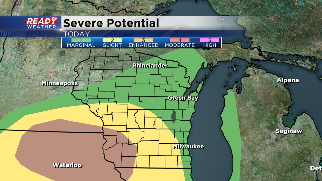
An Enhanced Risk (level 3 of 5) for severe storms remains in place for the western half of the area, with a level 2 of 5, Slight Risk for the lakeshore.

Download the CBS 58 Ready Weather App to track any warnings sent directly to your phone.
---------------------------------------------------------------------------------
Updated 1:00 p.m. June 17, 2021
After some of us saw showers and storms late this morning, the atmosphere is quieting itself down again. Until later this evening and into the overnight. Computer models are still not in the same line of thinking. One has most of the action moving through by midnight while another reliable model shows the storms pushing through mainly overnight. Obviously, this is a fluid situation, and the CBS 58 Ready Weather team will stay on this. The "enhanced" risk for severe weather has shifted a bit east, just to the west of the metro.


We need the moisture for sure. The deficits are growing. More than 8, 9 inches across Kenosha County. This is why this general area is under an "Extreme" drought status. Everyone else is under a "Slight" category. Hopefully we get the rain and miss most of the severe weather.

____________________________________________________________________________________________________________
Updated: 9:29 a.m. June 17, 2021
A few showers and storms along a thin line that started in western Wisconsin have held together and moved into our local area. Some of these showers and storms could come with brief downpours, wind gusts to 40 mph and some small hail. By noon this activity will be over Lake Michigan setting the stage for our round of storms this evening and tonight.

Our chance for evening and overnight storms continues especially from 7 pm through 5 am. A few of the storms, even at night, could be strong to severe with damaging wind as the main threat. The rest of the forecast below is on track.
------
Posted: 7:04 a.m. June 17, 2021
After a calm and comfortable couple of days the heat and humidity will increase and our best storm chance in over a week arrives. A few stray showers or storms can't be ruled out during the day on Thursday but the better chance for rain comes later this evening, after 7 PM with a round of strong thunderstorms and rain.

The pockets of heavy rain will likely last into early Friday morning before we start to dry out. Everyone needs rain but totals will depend heavily on how strong the thunderstorms are. Right now southern counties have the best chance to see steady downpours with up to or over 1.50" of rain possible there. Those that just see showers or a brief storm may only get a few tenths of an inch of rain.

The threat for severe weather is better in Iowa and southwest Wisconsin where they are under an enhanced (level 3) risk of severe weather. Our severe risk hasn't changed much from Wednesday with our western counties in the slight (level 2) risk and lakeside and northern counties in the marginal (level 1) risk for severe weather.
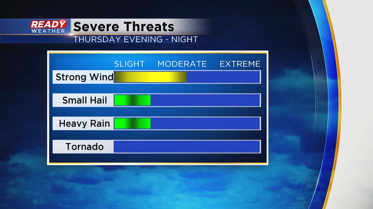
If we do see severe storms in southeast Wisconsin, strong wind will be the main threat. Some hail and heavy downpours are also possible but the tornado risk locally is very low.
The storms today will form along a warm front which will bring the heat back to our area after a few days in the 70s. Highs on Thursday will likely reach the upper 80s and an isolated 90* is not out of the question. Friday looks even higher with highs around 90.

As the heat rises so will the humidity. Dew points Thursday morning started out in the 40s. By the late morning dew points rise into the 50s but still comfortable. In the afternoon most of us will start to notice the humidity with mugginess definitely in place by the evening. The humidity will be in full force for Friday pushing heat index values close to 100. The humidity will drop slightly going into the weekend.

Download the CBS 58 Ready Weather app to track the storms with the interactive radar and get alerts if severe thunderstorm watches or warnings are issued.