Winds Of Change Sweep Across Wisconsin
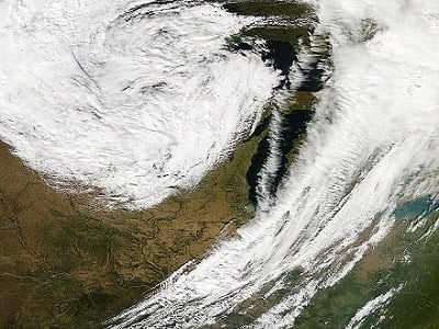
A potent storm system tracked from Minnesota to just north of Milwaukee yesterday bringing strong winds and changeable weather with it. The snapshot below was taken by the NASA Aqua satellite as it flew overhead yesterday afternoon. It shows the nice clearing, or "dry slot" we had in Southeast Wisconsin just ahead of the low clouds and cold air that arrived in the evening. Also, notice the comma-like cloud formation common to mid-latitude cyclones.
The storm packed a powerful punch with high winds. Some peak wind reports shown below occurred mainly in the evening. The Milwaukee report is from Timmerman Airport at 6:45 pm. Mitchell International Airport clocked a peak gust of 37 mph. These winds followed a secondary cold front which dropped temperatures from the 70s into the 50s over a four hour stretch yesterday evening. Our winds remain strong today from the northwest between 15-25 mph with gusts to 30 mph. Northwesterly winds almost always bring in cooler air and today is no different. High temps will be about 20° cooler today than the past two days.

As the storm continues to move away our winds will diminish tonight and cloud cover is expected to thin. This will lead to some cool readings tomorrow morning. However, another cold front arrives Thursday with an even colder patch of air sliding south Friday and Saturday. This could lead to our first frosty mornings of the season. Stay tuned to CBS 58 and we'll keep you posted.