Severe threat lowering as we head into the overnight


Update: 10:45 p.m. April 28, 2025
Our threat for severe weather is rapidly starting to dwindle. Sure it's been warm and it's been a bit sticky. But we don't have any lift in the atmosphere nearby at this hour. All of the action remains in western Wisconsin:

As highlighted on that radar image, the outflow wind from the thunderstorm line is now moving ahead of the main line of storms. When this happens, it tends to reduce the amount of energy available to the line. Effectively, it shuts down the severe threat. There may still be some small hail and gusty wind in spots, but as the lines advances eastward, it may continue to run out of gas.
There is still a small chance some of this line makes it into our area. Should that happen, it would not be until after about 3 a.m. or later. By then, the threat for severe weather will be quite low.
One important takeaway for Tuesday: tumbling temperatures as the cold front passes through. It will be warmer at 7am than it will be through the afternoon. Plus, the strong wind may make it feel cooler.

So it appears we dodged the severe weather threat tonight. But remember that this is only late April and there's plenty of time for more stormy nights.
- - - - - - - - - -
Update: 8:25 p.m. April 28, 2025
Things remain warm but quiet across our corner of the state at this hour. Temperatures have actually gone up in Milwaukee due to the wind moving to the southwest. Many spots are still around 80 degrees!

Meanwhile, strong to severe storms have continued to develop in a line across western Wisconsin:

That storm line is not expected to reach our area until closer to midnight. And that's if it can all hold together.
It will remain rather warm through the bulk of the night. That warm air--and some humidity--could help to fuel the storm line as it comes into area. Biggest concerns would be for damaging wind gusts. But we cannot rule out a few brief spin-ups, which may prompt a tornado warning.
There have already been some radar indications of tornadoes in western Wisconsin. Around 8:13p, radar indicated a tornado debris signature near Bridge Creek (which is about 20 miles southeast of Eau Claire).

We continue to monitor conditions and will provide updates here and on-air as needed. Right now, the expectation for things to weaken a bit as that storm line advances eastward across the state tonight.
- - - - - - - - - - -
Update: 5:45 p.m. April 28, 2025 - JD Rudd
We are still playing the "waiting game" right now when it comes to thunderstorms. There's plenty of warmth and energy around, but there's also a bit of a lid in the upper part of the atmosphere, holding things back.
The visible satellite image shows us some bubbling clouds in the western part of the state, where storms are trying to form:

But even in that area, the activity is having a hard time getting going due to that cap in the atmosphere.
Still, there's a shot at some rain and storms later tonight as the cold front moves into the area. Right now, that front is helping to spawn a line of storms in southern Minnesota:

That line is about 250 miles away and (if it holds together) would not arrive until closer to midnight.
We'll continue to keep eyes on the radar and see if something develops over the next few hours. As we get closer to sunset, the cap in the atmosphere could weaken just enough to allow a few storms to pop.
- - - - - - - - - - - - - -
Updated: 3:10 p.m. April 28, 2025
Temperatures are rising. This is now the second warmest day this year for Milwaukee:

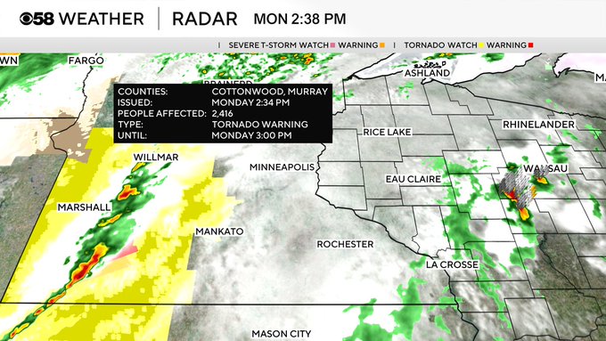
A Tornado Watch sits to our west with one tornado warning so far. Closer to the area storms are firing near Wausau. The light and spotty line extending down through La Crosse is the next area we will watch for as it moves over. That could bring some evening storms. The second line associated with the watch would arrive midnight. The risk for severe storms holds steady during the overnight.
Updated: 1:15 p.m. April 28, 2025
Conditions are warm and breezy early this afternoon. And for now, quiet. But the atmosphere is primed for storms today and anything that builds could quickly turn severe. It does look like the afternoon is mostly dry, so get out and enjoy the warmth! But keep an eye to the sky as those towering cumulus clouds show the potential for storm development. And be prepared to take it indoors as storms develop. That risk grows more so as we head into the evening.

Updated: 10:26 a.m. April 28, 2025
The first round of storms this morning has just about wrapped up. Storms in the northern part of the state have behaved and stayed below strong/severe limits. A few showers have formed in a broken line down to southwest Wisconsin. A few storms have formed as well. We will watch these storms as they move across southern Wisconsin with the potential for some small hail.

The uncertainty for storms is still there most of the afternoon and evening with the best chance for storms locally in our northwest counties like Fond du Lac and Dodge County. The timing for potential storms has become a bit more in focus with the best chances after 4 PM through 4 AM Tuesday morning. The rest of the severe risk and threats outline below is on track.
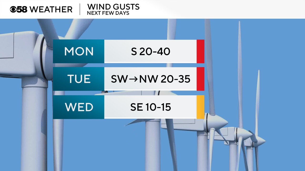
In addition to the chance for storms, Monday is going to be a windy day with a south wind gusting to 40 mph at times. This will bring in all the warm air and push highs well into the 70s in many locations. The wind will strong with gusts to 35 mph most of Monday night and Tuesday.
------
Posted: 5:09 a.m. April 28, 2025
Hopefully you enjoyed a weekend that was nice and dry. That could change Monday when multiple rounds of storms are possible. Three rounds of storms look possible, but there is plenty of uncertainty with each. Overall western Wisconsin and northern Wisconsin has a better chance to see the strong to severe storms. Some of our northwest counties like Fond du Lac and Dodge County may have our best chance to see severe weather.
The first round of storms is currently in place across northern Wisconsin with some showers trying to develop in eastern Iowa and southwest Wisconsin. Our northern counties have the best chance of seeing those storms.
Here's a statewide view of radar that will update with time:


A second round of storms is possible from the mid afternoon into early evening and a third round from the late evening through early Tuesday morning. These storms have the best chance to be severe if they happen with the bigger tornado risk during round two in the afternoon and early evening and more of a high wind risk with the third round from the late evening into early Tuesday.

The Upper Midwest is in the bullseye for severe weather. While there is uncertainty whether we see the storms in southeast Wisconsin, there is a more likely chance for seeing severe storms with multiple tornadoes possible in western Wisconsin, Northern Iowa and SE Minnesota where the Level 4 Moderate Risk in red is in place. Most of southeast Wisconsin is under a Level 3 Enhanced Risk with a Level 2 Slight Risk for Milwaukee, Racine, Kenosha Counties.

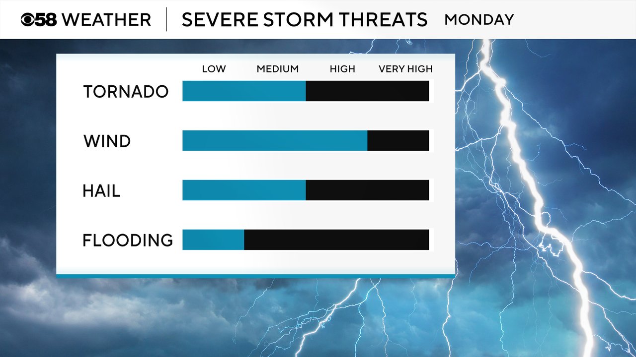
The tornado risk for Monday for Wisconsin standards is pretty high but much better in western Wisconsin. The chance for afternoon/evening storms locally will give us the best chance for tornadoes. Damaging wind remains the biggest threat locally with a possibility for hail. The flooding risk is not super high as the storms should be fast movers.
Rain totals with all of the storms we get Monday into early Tuesday should range from 0.10"-0.50" for most of southeast Wisconsin but higher totals are definitely possible with any severe storms we get.

Download the CBS 58 Weather app to track the storms and see any forecast changes.