Mid Evening Update: Line of storms has weakened, but is still producing strong winds


Updated: Friday, August 11th 9:40pm:
The gust front is beginning to outrace the line of rain and storms, which usually will cause them to weaken. That being said, wind gusts have been between 45-50 mph have been reported in Fond du Lac and Dodge counties.

-------------------
Updated: Friday, August 11th 8:50 pm:
The line of storms has been on a weakening trend overall since the sun has set, but some lingering gusty winds have knocked down trees in Marquette county which has prompted a Severe Thunderstorm Warning that includes western Fond du Lac county until 9:30pm.

Strong winds between 45-60 mph will be possible in this line of rain and storms.
----------------------------------------------
Updated: Friday, August 11th 7:15pm:
A Severe Thunderstorm Watch has been issued for all of southeast Wisconsin until 1am. Damaging wind and hail are the main concerns.

------------------------------------------
Updated: Friday, August 11th 7:00pm:
Quite the complex of severe storms tracking through west central WI this evening.

The Storm Prediction Center says another Severe Thunderstorm Watch will be needed east of the current one (in pink). How much of southeast WI will be included in that watch is TBD. Will update when the watch is issued.
--------------------------------------------------------
Updated: Friday, August 11th 5:00pm:
A cluster of severe storms has developed near the Twin Cities and is tracking to the southeast at 40 mph.

The storms are several hours away from reaching southeast Wisconsin, likely reaching western spots around 10 pm and Milwaukee closer to midnight.

Storms could contain strong winds and hail.
---------------------------------------------------------------
Updated: Friday August 11th 3:00pm:
Several breaks in the cloud cover along with a breezy southwest wind has help boost temps well into the 80s this afternoon.

Dew points are in the low to mid 60s, and this combined with the warmth has generated some instability across southern Wisconsin. A couple of isolated showers have popped with this instability, and a few more may develop through the course of the afternoon.

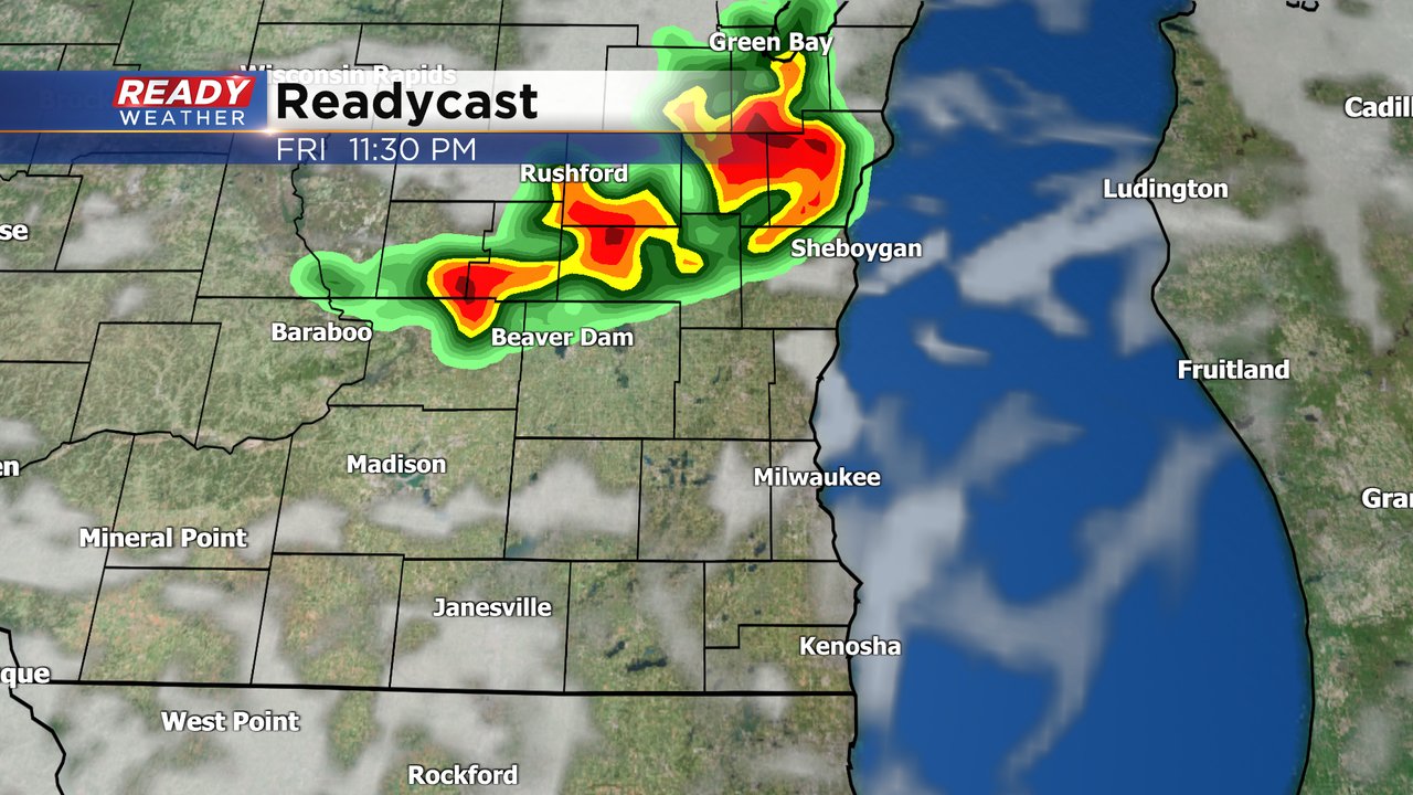
Our attention is on late this evening into the overnight hours for the potential for strong to isolated severe storms. Storms are developing west of the Twin Cities with more expected to develop late this afternoon. These will track southeast through the evening hours, reaching southeast Wisconsin after 9-10pm. A Severe Thunderstorm Watch has been issued until 10pm for western Wisconsin where storms more numerous severe storms are expected.

We will lose some instability after sunset in southeast Wisconsin, so by the time the storms move through between 10pm-1am, they should be a little weaker compared to when they track through western Wisconsin. That being said, a few storms still may be strong to severe when they move through with damaging wind and hail as the primary threats.

Showers and storms exit the area by 2am. Download the CBS 58 Ready Weather App to have warnings sent directly to your phone.
---------------------------------------------------------------
Updated: 12:55 p.m. Aug. 11, 2023
Radar continues to be suspiciously quiet. Although we did expect a fairly tame mid part of the day, you can feel that humidity!

Updated: 9:12 a.m. Aug. 11, 2023
Our first round of rain is nearly over and it didn't amount to much. Most of southeast Wisconsin just saw a few light showers or sprinkles as the line of showers fell apart over Madison. A few of our local northern counties did see some rumbles of thunder and a few downpours.
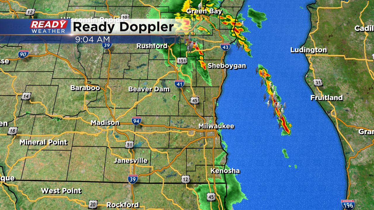
The next round of storms could be a few pop ups that happen in the afternoon and early evening. If these happen they will be fairly isolated and random so not everyone sees them. One or two of these storms if they do pop up could be on the strong to borderline severe side. The best chance for severe storms is still later this evening into the early overnight when storms form in western Wisconsin and roll through our local area between 9 PM - 2 AM. Damaging wind and hail remain the biggest threats with these storms but an isolated tornado is possible.
The rest of the forecast detailed below is still on track!
------
Posted: 5:27 a.m. Aug. 11, 2023
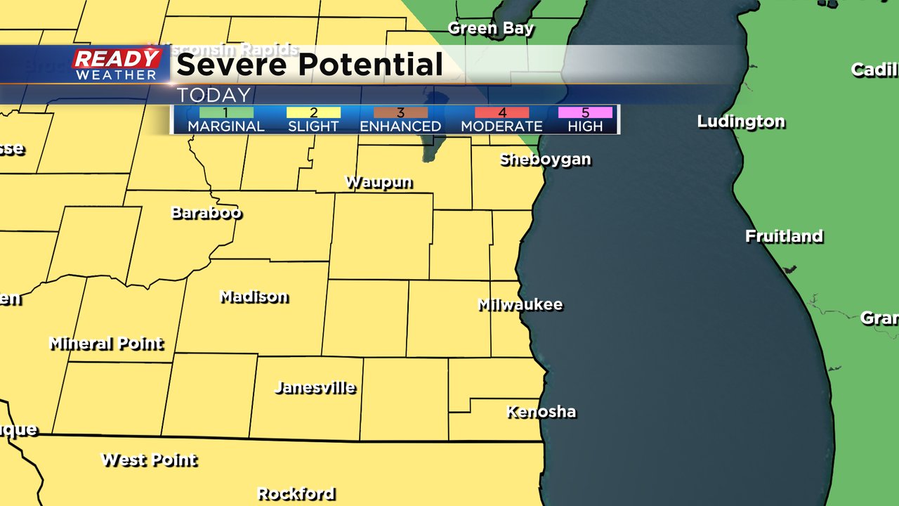
Our next chance for severe weather has arrived. For the last three days most of southeast Wisconsin has been in the Level 2 Slight Risk for severe weather for Friday. Now that Friday is here, that risk hasn't changed much with all of southeast Wisconsin in the Slight Risk.
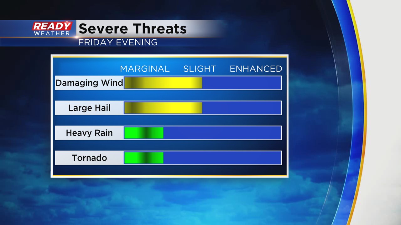
Damaging wind and hail are the main threats for any storms that develop but an isolated tornado cannot be ruled out and even some brief flash flooding if heavy storms develop.
Our first round of rain and a few storms is currently rolling through Wisconsin. Southeast Wisconsin will see these impact the area from 6 AM to Noon with dissipating showers and a few isolated storms. Some could stay dry during this time.
A few isolated pop up showers and storms will be possible during the afternoon and early evening with a very low and isolated severe threat. The best chance for severe storms will be late this evening after 9 PM.
Rain totals during the day on Friday will greatly vary depending on who sees the strongest storms. At least a tenth to quarter inch is likely for most of us but a half to full inch of rain will definitely be possible in hometowns that get thunderstorms.

Download the CBS 58 Ready Weather app to track the storms and get alerts if watches or warnings are issued.