Foggy Start, But A Sunny Finish
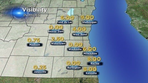
Dense fog developed overnight and has been slow to burn away this morning. The worst of the fog developed primarily inland from Lake Michigan. Many locations reported visibilities at or near zero from Waukesha west. This is where clouds cleared late yesterday afternoon and overnight.
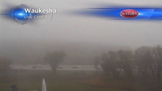
Cloud "cover" acts like a blanket over the earth's surface; trapping heat escaping from the ground. With clear skies this heat is able to escape into the atmosphere allowing the air to cool more effectively. Under the right conditions, temperatures will cool to the dew point. At this point the air is saturated; it can't hold any more moisture at that temperature and Water vapor begins to condense into tiny liquid droplets producing a cloud on the ground, or fog. Here's the view from our Waukesha camera around 8 AM this morning...
This type of fog is called radiation fog and is very common in the fall through early spring. As the sun rises, some of the energy penetrates the fog and warms the earth. The air in contact with the earth is then heated reversing the process and dissipating the fog.
Obviously fog can greatly affect driving conditions. Here are a few tips that will come in handy over the next few months.
1) Slow down gradually versus slamming on the brakes.
2) Make sure all your lights are on, but only the low beams at night. High beams reflect off the moisture droplets in the fog, making it harder to see.
3 )Be patient. Avoid passing, changing lanes and crossing traffic.
4) Be sure to increase your following distance. You will need this extra distance to brake safely.
