10 PM Update: Severe threat diminishing after widespread wind damage across parts of the area


10:00 PM Update:
The severe threat is diminishing across southeast Wisconsin. The line of severe storms that moved through Sheboygan, Dodge, Fond du Lac, Washington, and Ozaukee counties produced numerous tree and power line damage, including a barn in NE Fond du Lac co. that lost it's doors and part of it's roof.

Severe Thunderstorm Watch continues for counties along and south of I-94 until midnight besides Jefferson county.

--------------------------------------------------------------------------------
8:30 PM Update:
Severe thunderstorm warning is now in effect for eastern Fond Du Lac and Sheboygan counties through 9:30 p.m. This squall line has a history of producing significant tree damage in Marquette county and produced a 67 mph wind gust near Portage.

This line of storms is tracking SE at 50 mph. Expect damaging winds over 60 mph as this line of storms moves through.

-------------------------------------------------------------------------------------------------------------------------------------------------------

7:30 PM Update:
Strong to severe storms continue to roll across central and western Wisconsin this evening. Storms are moving southeast around 35 mph. We expect more warnings to be issued downstream of the line.
Here's the latest storm track for strong gusty winds over 50 mph. A lot of heavy rain and lightning is also possible with the passage of these storms.
______________________________________________________________________________________________________________

6:00 PM Update:
Showers and storms have quickly developed to our northwest this early evening. A severe thunderstorm watch has been issued for our entire area until midnight. Damaging winds to 70 mph, hail, and heavy rain is likely.
These storms will start to accelerate as they move southeast. Storms remain possible from 9 pm through 2 am. The bulk of the storms will be overhead closer to midnight.
______________________________________________________________________________________________________________
4:00 PM Update:
No changes after looking at the latest models. Milwaukee set a new record high temperature today, and that heat and humidity will help fuel showers and storms later tonight.

Most of the models put the brunt of the storms across Fond du Lac, Sheboygan, Washington, and Ozaukee counties between 9 pm and 2 am. Those counties will have the greatest chance for 70 mph winds.
The bulk of the storms will be over the area at midnight.
There isn't a severe thunderstorm watch at this point; however, we do expect one to be issued later tonight.
______________________________________________________________________________________________________________

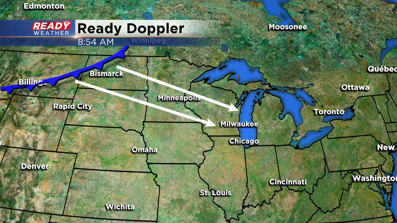
The hottest day of the year will set the stage from strong to severe storms across souteastern Wisconsin late this evening into the overnight.
Take a look at the complex above. This area of convection will continue to explode as it moves southeast over the next several hours. The complex will move into a very favorable area of heat and humidity.

These storms are expected to move across our area between 9 pm and 2 am. The greatest risk is for damaging winds. The greatest wind threat will be along and north of 94.
______________________________________________________________________________________________________________
Updated: 11:30 a.m. June 2, 2020
The forecast is still on track for storms tonight so we continue to be clear from any active weather during our day, but we won't be able to escape the heat. Your Heat Index values are already in the upper 80s late this morning. Feels-like temps will push to the mid 90s this afternoon. Use common sense outdoors today. Wearing light clothing, staying hydrated, taking breaks and finding some shade are your best options as you enjoy this hot summer day. Tonight the CBS58 Ready Weather App is a great tool to track night time storms. Hail and wind are the greatest threats with the expected storms as well as frequent lightning. Our app not only provides radar, but also a future radar option to help you time out storm arrival in your area.

Updated: 9:00 a.m. June 2, 2020
No changes to the ongoing forecast found below with heat and humidity today making most spots at least feel like the 90s. Storms arrive this evening and overnight with the best time period for severe storms from 8 pm to 2 am. The focus for the storms will be ahead of a front that is currently in North Dakota. That front is expected to move southeast arriving in southeast Minnesota sparking storms there by 5 pm and then moving into southeast Wisconsin. Wind and hail will be the main threats with any storms but a tornado or two cannot be ruled out.
------
Posted: 6:25 a.m. June 2, 2020
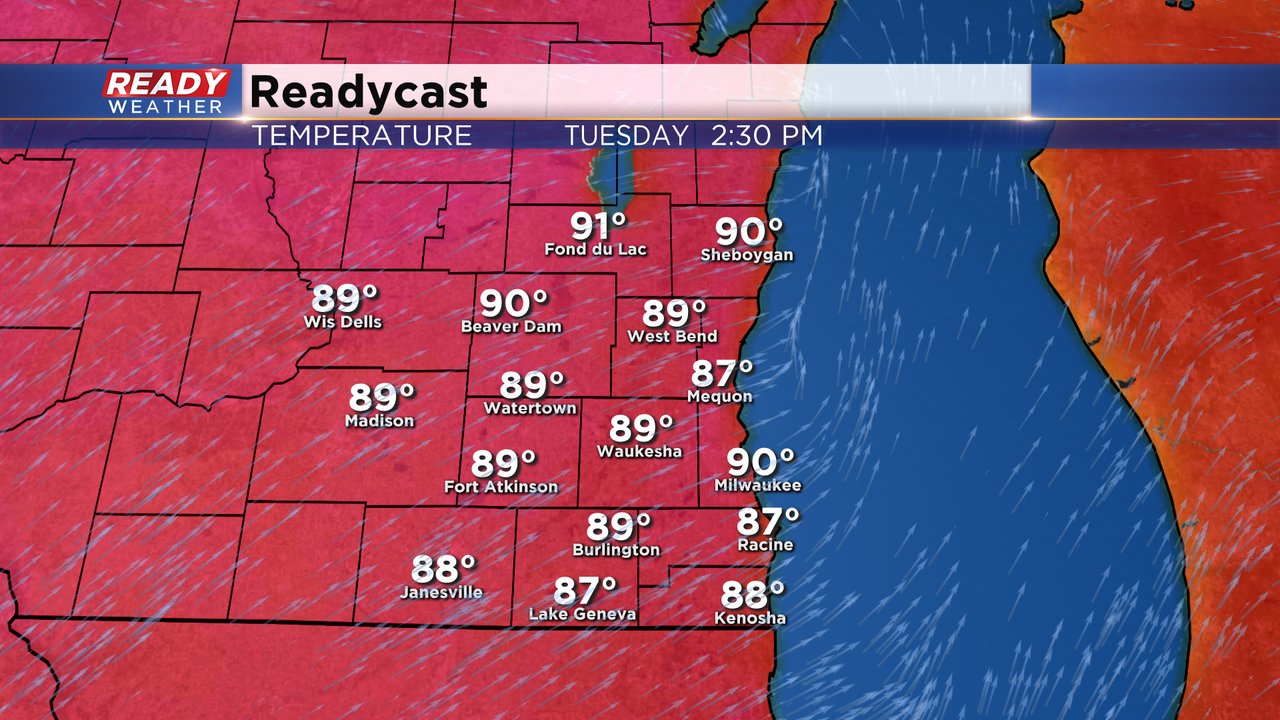
The hottest day of the year will give way to strong to severe storms Tuesday night into Wednesday morning. Tuesday morning started out very mild with lows around 70* and is expected to stay warm all day. Highs will reach the upper 80s to around 90* in many locations making it the hottest day of 2020 and the first 90 in over 300 days since our last one on August 5th.
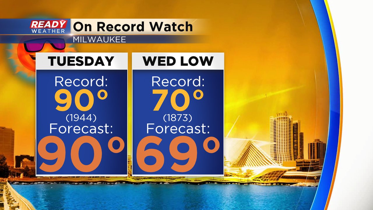
Not only is it going to be hot but it could be record-breaking heat. The current record for Tuesday is 90* set back in 1944. We could also break a record for the warmest low temperature on Wednesday morning. That current record sits at 70* and with a forecast low of 69* we will be close.
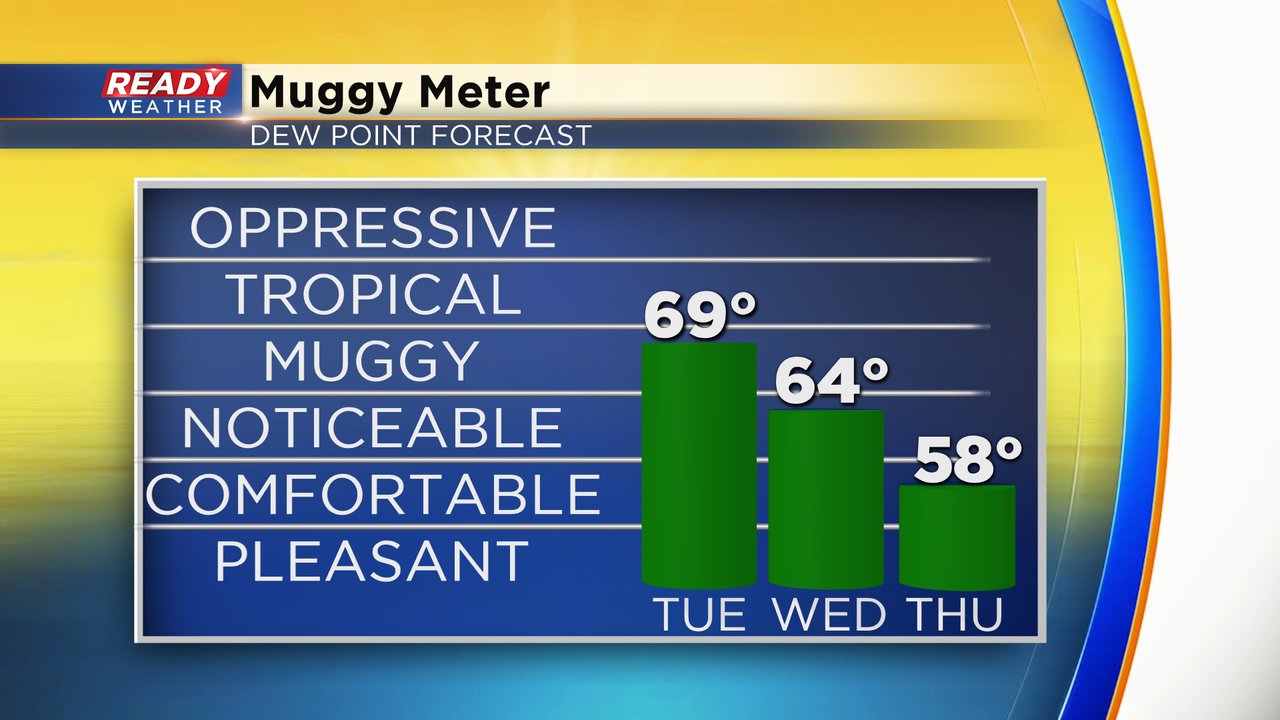
In addition to the heat, it is going to be humid. Dew points will get close to tropical levels in the upper 60s on Tuesday. Still expect a humid day Wednesday before a brief break on Thursday. With the humidity the feels like temp on Tuesday will reach the middle 90s in some spots. Make sure to hydrate!
All of this heat and humidity will add a lot of fuel to the atmosphere sparking a chance for storms. The best timing looks to be around or just after sunset with storms lasting through Wednesday morning.

Some of the storms could be strong or severe. A good chunk of Wisconsin is in the enhanced risk for severe weather which is the third of five risk levels. The main threats will be large hail and damaging wind as storms form a line but a tornado or two can't be ruled out. Fond du Lac and Sheboygan Counties have the best chance for severe weather but everyone needs to be weather aware.

Some of the storms could provide some quick, heavy rain but they should be fast moving so flooding is not a big risk. Locations that see the storms could get up to a half inch of rain.

With the possibility for severe weather make sure you download the CBS 58 Ready Weather app. The app will give you alerts if watches or warnings are issued for your location. A watch means that conditions are favorable for your. A warning means that dangerous storms are happening or imminent.