Blizzard Warning until 3 AM for Fond du Lac and Sheboygan counties. Winter storm warnings continue overnight.


Updated: Friday, January 12th:
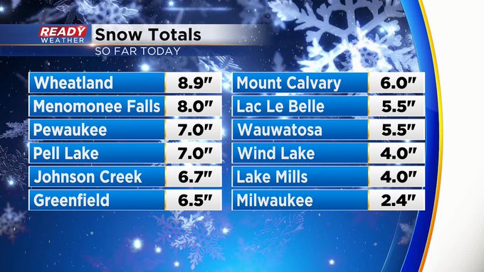
Here are some updated snowfall totals. Keep in mind, the January average for the area is 14.9"! Some areas might get close to that by Saturday night.

The National Weather Service has issued a Blizzard Warning for Fond du Lac and Sheboygan counties until 3am. Travel will be very difficult to near impossible this evening into tonight due to low visibility and strong winds in these wide open counties.
Even though your area isn't in a blizzard warning, near blizzard conditions are likely across the entire area.

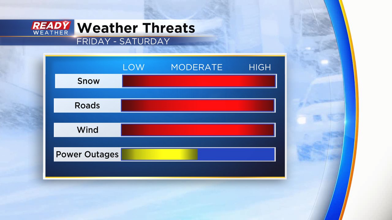
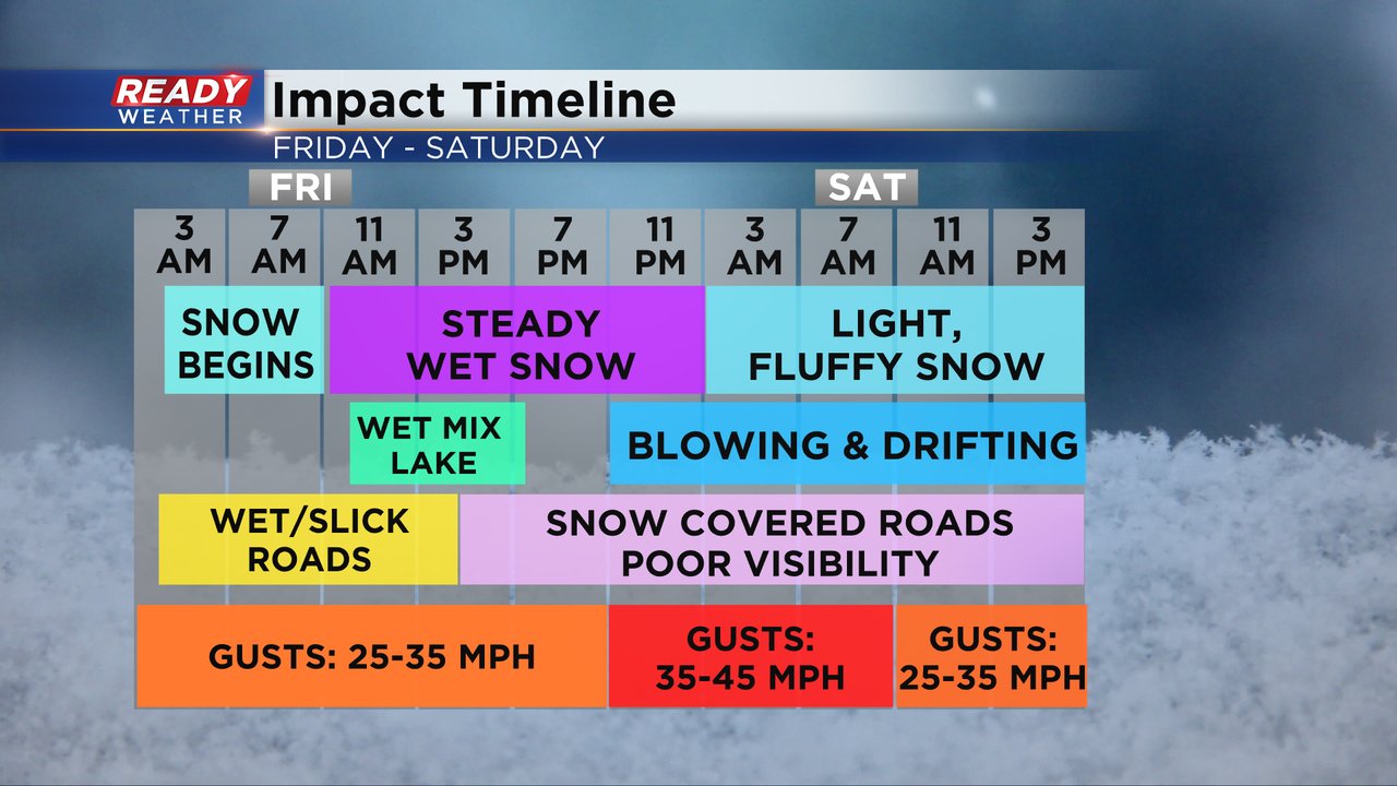
Here's the impact timeline for the rest of tonight into Saturday.


The steady snow will continue through midnight. Light snow showers will persist on Saturday, along with slick roads. I expect more power outages tonight with winds gusting between 30 and 40 mph!
-------------------------------------------
Updated: Friday, January 12th 1:57pm:
Moderate to heavy snow continue to fall everywhere except right along the lakefront. Here are updated snow totals as of 1:30pm.

We are still getting a rain/snow mix along the lakefront in Racine and Kenosha, so snow totals there in particular have been low, but that was expected. We are expecting snow to start accumulating there by late afternoon and continue into Saturday.

Visibility had been down to a quarter mile at times today with the pockets of heavier snow. Visibility will become worse later tonight as the now becomes fluffier and the winds pick up.

-----------------------------------------------------------------------------------------
Updated: Friday, January 12th 12:25pm:
Snow continues to pile up quickly. Here's the latest as of noon:
On this track we are set to see higher end forecasted totals with steady snow expected through the day and evening before becoming lighter overnight and eventually scattered in nature Saturday. The forecast remains on track with snow, wind, poor travel and eventually cold. Stop back for updated totals through the day.
Updated: Friday, January 12th 10:05am:
Moderate to very heavy snow continues to fall across southeast Wisconsin this morning with some rain mixing in near the lakefront in Racine and Kenosha.

Many locations away from the immediate lakefront have already picked up 3-6" of snow and counting. This is still a wetter snow that's good for making forts and snowmen, but it's also accumulating on branches and power lines which is causing power outages.

Snow is accumulating very easily on roads away from the lakefront. As of the update time in this post, ramps from I-94 East to I-41 North and South in the Zoo Interchange are closed right now due to snow.

We've upped the snow totals for areas away from the lake based on what has already been able to accumulate. Much of the area will pick up 8-14" of snow with lower totals right along the lake due to the mixing that's currently going on. Accumulation in those locations will pick up later this afternoon into Saturday.

--------------------------------------------
Updated: 8:11 a.m. Jan. 12, 2024
Some of the heaviest snowfall from early Friday morning is starting to take a break but there's still some pockets of moderate to heavy snowfall. Expect steady snow to continue most of Friday. The worst part of the storm is still expected this afternoon and evening when steady drier snow combines with strong wind to cause near whiteout conditions.
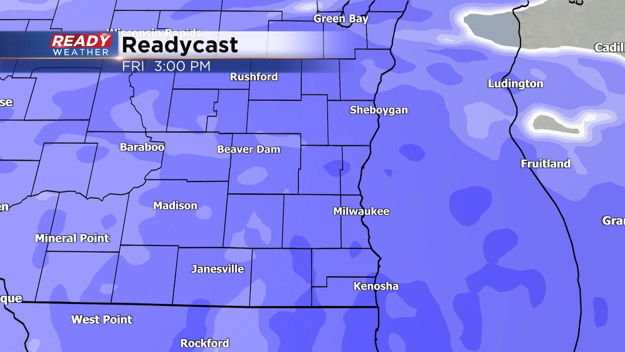
One of the best ways to see who is getting the heaviest snowfall and wind impacts is on visibility. Check out the current visibility that will update with time below:

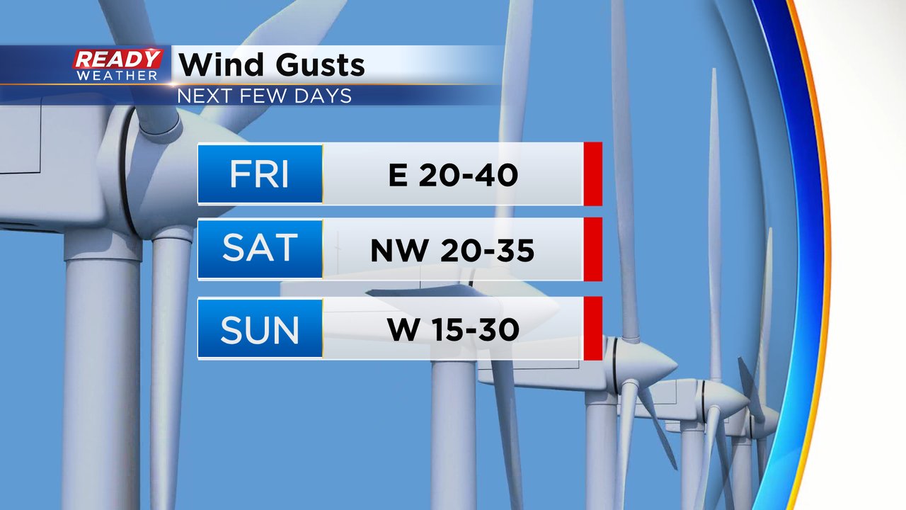
Wind gusts around 8 AM hit over 40 mph in some lakeside communities with Kenosha even gusting close to 50 mph!

The strong wind is one of the biggest threats with this storm and could lead to power outages. The snowfall Friday morning is still a packing snow which sticks to trees and power lines weighing them down then adding a 40 or 50 mph gust on top of it could cause the branches and power lines to come down. The rate of the snow, bad road conditions are also high threats.
Our focus Friday is on the snow, but don't forget about the cold air as well. Wind chills go sub-zero Saturday evening and stay that way most of next week. Right now Monday and Tuesday look coldest with morning wind chills to -30, afternoon air temps in the single digits and wind chills staying well below-zero all day.

Snowfall amounts remain on track with 6-12" for most of southeast Wisconsin. Keep checking the CBS 58 Ready Weather app for snow total reports and the updated forecast!
------
Updated: 6:03 a.m. Jan. 12, 2024
The snow is quickly rolling in this morning and shortly after it begins we are seeing heavy bands of snow roll through causing quick accumulation. Roads are already snow covered in our southern counties with slick spots and rapidly slowing drive times in the Milwaukee Metro.
Here's a radar image that will update with time:

The wind will be a huge factor with this storm. Winds gusts on Friday and Saturday are expected to reach 40 mph or higher at times. Wind speeds that high will cause blowing and drifting snow and near whiteout conditions. Sunday is also still windy even though the snow is done falling by that time.
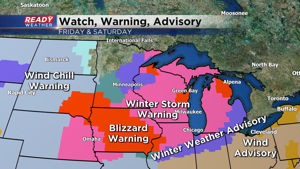
While all of southeast Wisconsin is now under a winter storm warning, look at the red areas on the map below to our west in Iowa and even to our north in the Green Bay and Fox Valley where a Blizzard Warning has been issued. A blizzard is defined as frequent gusts or sustained wind over 35 mph and visibility a quarter mile or less for at least three straight hours. While we may not get to that criteria locally, we will come close with near whiteout conditions at times.
The rest of the forecast below, including snow totals, remains on track.
------
Posted: 4:31 a.m. Jan. 12, 2024
Snow is rolling in early Friday morning and will continue through the rest of the day. The latest data shows a possibility for some heavier bursts of snow during and just after the morning commute.
We may see some lighter snowfall in the early afternoon but by mid-afternoon through the late evening hours heavy snow is expected and with dropping air temperatures the slush factor goes away lakeside and the wind picks up. This will be the worst part of the storm.
By Friday night into Saturday the rate of the snow decreases but light scattered snow showers are still expected most of Saturday with a few flurries lingering into Sunday morning. Even if the rate of snow drops off Friday night and Saturday, the blowing snow and strong wind will continue with gusts to 40 mph.
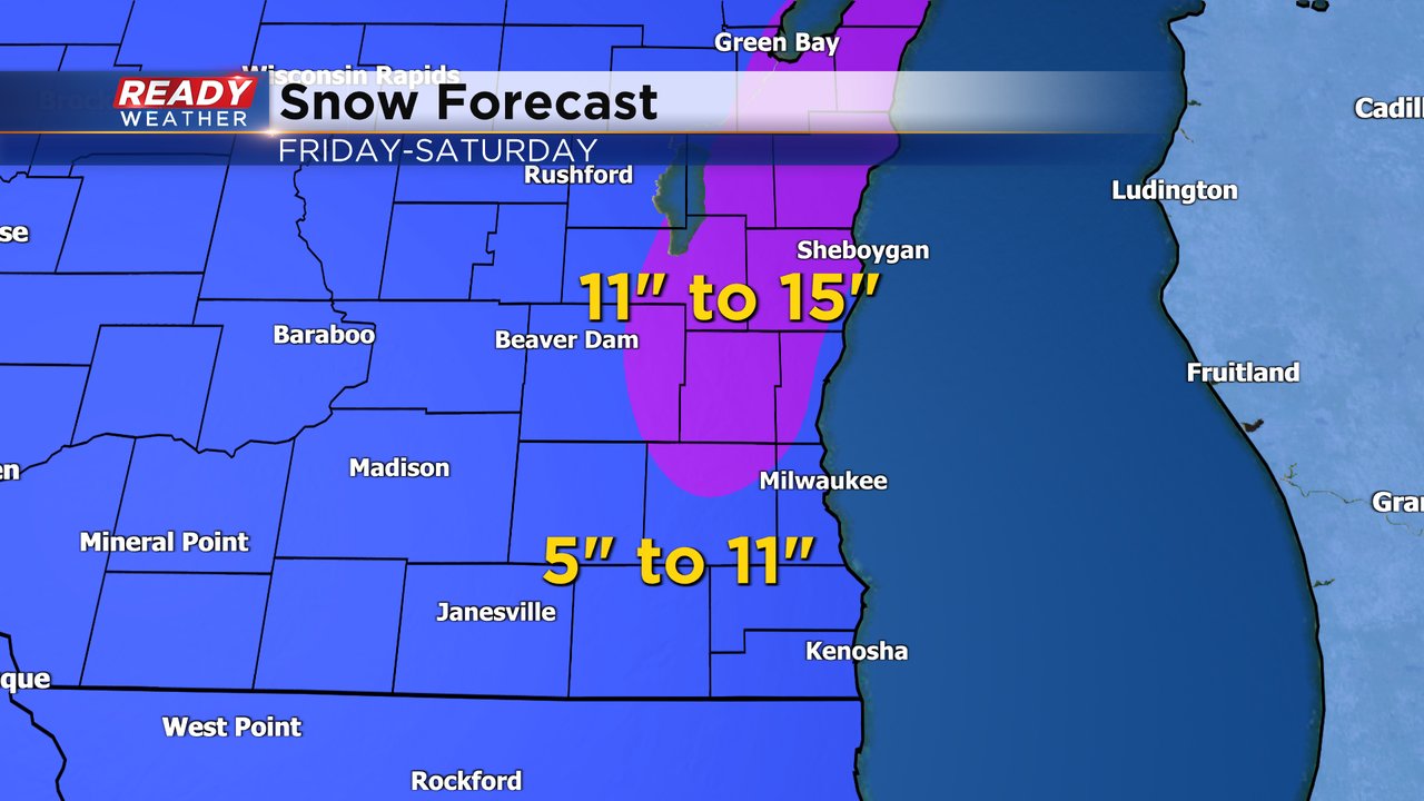
We've been able to make some adjustments to the snow forecast to reflect what parts of our local area will get the heaviest snow. It appears an area from Sheboygan into eastern Fond du Lac County through most of Washington, Ozaukee County and eastern Dodge County and into northern Waukesha County could see the heaviest snow from 11-15". The rest of southeast Wisconsin is looking at 5-11". Lakeside the totals will be closer to 5" if we see more mix/slush Friday but closer to 11" if we don't get as much mix. Our southern and western counties away from the Lake should prepare for over 8".
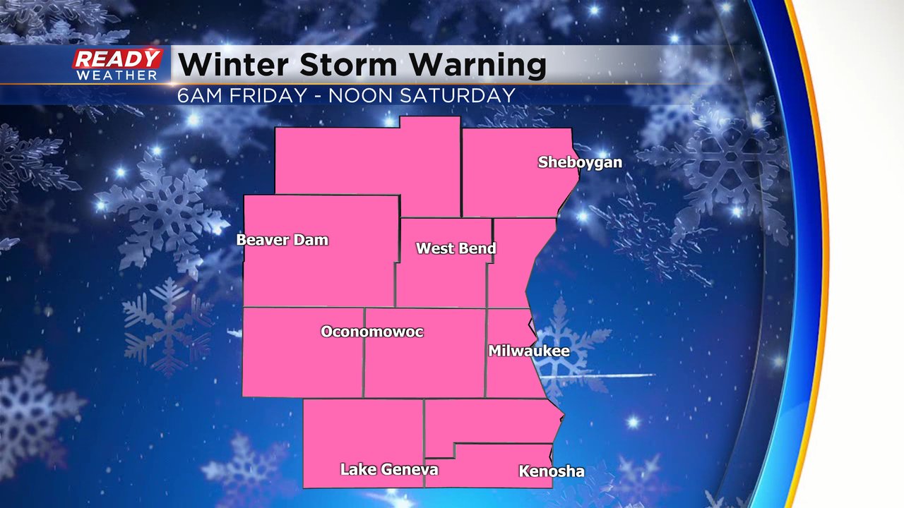
A winter storm warning goes into effect for all of southeast Wisconsin at 6 AM Friday morning and lasts until noon on Saturday. The National Weather Service may decide to issue a Winter Weather Advisory Saturday afternoon and evening for the possibility for light snow and continued blowing and drifting snow.
Download the CBS 58 Ready Weather app to track the snow and near whiteout conditions for Friday and Saturday.