Mild Temperatures Abruptly End
The fall season continues to be a real treat across the area as we are slowly being eased into our cold season. Take a look at the high temperatures to date for Milwaukee.
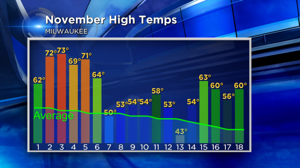
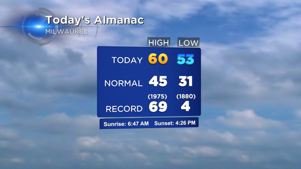
Despite the rain, temperatures managed to hit 60° in a few spots today, including the Metro. Only two days so far this month failed to meet or exceed the average high temperature. You can see that average temp line gradually falling as the normal high temperature for today's date is just 45°. Here's a quick peek at today's Almanac for Milwaukee.
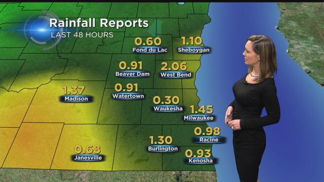
Along with the mild temps the past couple days we've received some decent rainfall amounts. Click on the thumbnail image of this story to see those totals in a larger view.
As we move forward some big changes are expected. The breezy southerly winds are expected to turn west tomorrow, ushering in cooler air. Lows tonight will fall into the upper 30s with a gradually clearing sky. Highs on Thursday will only reach the lower 40s, which by the way, is still near normal. Friday, however, will come with even more winter like changes. The day will start quiet and cold with temperatures in the 20s. Look for increasing afternoon clouds with highs near 40° and snow arriving during the evening. There is still some uncertainty in the forecast surrounding the start of this event, but most models do hold off until well after the evening commute. The snow with accumulate through Saturday morning, before ending as a few flurries during the afternoon. Preliminary snowfall amounts are in the 2-4" range, with some higher amounts possible. Please keep a close watch on the forecast through the next 48 hours for updates. The CBS58 weather team will be monitoring the situation closely.
I'm meteorologist Rebecca Schuld