Groundhog Day Storm Starting to Come Together
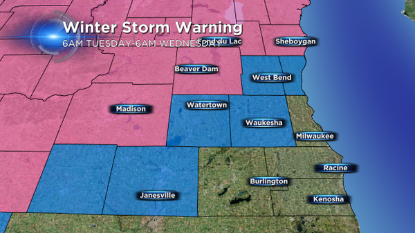
Model consistency continues to bring higher confidence to the forecast for Tuesday's storm. At this time weather concerns include a Winter Storm Warning for Dodge, Fond du Lac, and Sheboygan counties. The warning runs from 6am Tuesday to 6am Wednesday. Additionally, a Winter Weather Advisory has now been hoisted for Ozaukee, Washington, Waukesha and Jefferson counties starting at 6am Tuesday and running until 6pm Tuesday. Here's a visual on the concerns.
Now let's dissect that latest information on snowfall. And rain. Because at this point, areas from Milwaukee southward along the lake may only see liquid precipitation. But temperatures are still close enough to the freezing mark that a little room for error should be included. Ultimately, the map that we have shown the past two days hasn't changed much. Take a look at the image below.
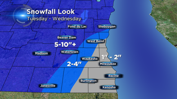
The dark shade of blue represents the highest snowfall totals, and continues to stay on track in the 5-10" range. There will be a wedge with snow and mix, before precipitation changes to rain so 2-4" is still possible in those areas, which is also reflected by the issuing of the Winter Weather Advisory. Lastly, the gray area looks to be mostly rain. However, because a mix may still occur early on, any quick bursts of mixed precipitation, like sleet, may drop a quick inch for accumulation.
The latest changes:
In house model data is slowing the onset of precipitation until the mid morning, around 9am to our west, eventually overspreading the rest of the area by about the noon hour. If precip does in fact hold off until noon across the greater Milwaukee area, we're looking at mostly rain. Second, that mix line continues to inch further north, so even spots in the advisory will likely see the transition to rain for late afternoon and through the commute home. The real challenge continues to be the sharp line between snow and rain/mix. High snowfall rates and heavy wet snow will still pose major problems for travel in the outlying areas. Wind will add another dimension of difficulty with reduced visibilities and blowing snow as the storm winds down overnight and into Wednesday morning.
Please stay with CBS58 for the latest weather developments and please download the CBS58 weather app for free.