Fall Storm on the Way
Today is the last mild day before a powerful fall storm moves into the area this evening.
Our temperatures remain mild Wednesday with highs in the mid 50s, but look for increasing clouds and wind as we get into late afternoon. Rain will spread in by this evening. This storm will also bring with it a chance for thunderstorms tonight, very strong winds tomorrow, much colder air and possibly a little snow by Friday morning... in other words, big changes on the way!
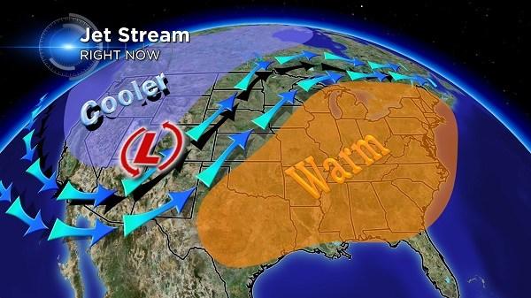
The past few days have features mild temperatures, relatively speaking, as the jet stream has been gliding north of our area. Meanwhile in the buckled area across the West Coast and Rockies, rain and snow showers have been in progress. As the storm shifts east today it gains energy from the swift moving jet stream, warm air from the Southern Plains and cold air wrapping in from Canada.

In addition, moisture from the Gulf of Mexico will aid in developing showers and thunderstorms over parts of the Mississippi Valley and into southern Wisconsin. This activity is set to reach our area by this evening. Thunderstorms are possible and isolated severe thunderstorms producing strong, damaging winds can't be ruled out. However, the greatest risk for severe weather is just to our south in IL, MO and IA.
We should see another good soaking from this system with rainfall potential coming in between .50" to 1.0" across most of Southern Wisconsin. The bulk of the rain will fall between 7 PM Wednesday and 4 AM Thursday.

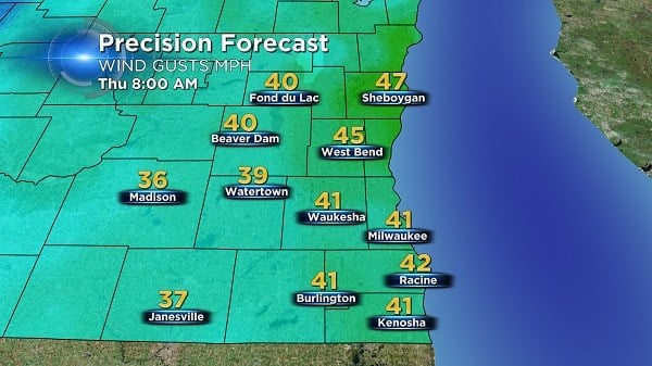
By early Thursday morning the storm will be passing to our northeast and will trail a strong cold front through the area packing extremely strong westerly winds. The winds will become sustained at 20 to 30 mph and gusts to at least 45 mph at times, making travel difficult for high-profile vehicles. The image below shows forecast wind gusts for Thursday morning. Our winds remain strong through Friday morning before diminishing to 10-15 mph Friday afternoon.
It is possible we see a few wet snowflakes Friday morning as temps dip into the low 30s and highs struggle to rebound to the low 40s. Though we aren't expected any accumulation around here, a couple of inches could fall in Northern Wisconsin.
Thankfully, a sunny weekend will follow this system with temperatures by Sunday heading back into the mid 50s!